Marne (river)
| Marne | |
|---|---|
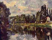 Marne River; painted by Paul Cézanne | |
| Native name | La Marne |
| Country | France |
| Basin features | |
| Main source | Champagne-Ardenne |
| River mouth |
Seine 48°48′57″N 2°24′40″E / 48.81583°N 2.41111°ECoordinates: 48°48′57″N 2°24′40″E / 48.81583°N 2.41111°E |
| Progression | Seine→ English Channel |
| Basin size | 12,800 km2 (4,900 sq mi) |
| Physical characteristics | |
| Length | 514 km (319 mi) |
| Discharge |
|
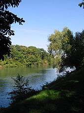
The Marne is a river in France, an eastern tributary of the Seine in the area east and southeast of Paris. It is 514 kilometres (319 mi) long.[1] The river gave its name to the départements of Haute-Marne, Marne, Seine-et-Marne, and Val-de-Marne.
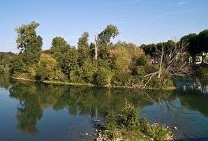
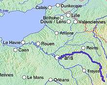
The Marne starts in the Langres plateau, runs generally north then bends west between Saint-Dizier and Châlons-en-Champagne, joining the Seine at Charenton just upstream from Paris. Its main tributaries are the Rognon, the Blaise, the Saulx, the Ourcq, the Petit Morin and the Grand Morin.
In the Champagne région, part of the flow is diverted through the artificial lake Lac du Der-Chantecoq. This ensures both flood prevention and the maintenance of minimum river flows in periods of drought.[2]
The Celts of Gaul worshipped a goddess known as Dea Matrona ("divine mother goddess") who was associated with the Marne.
The Marne is famous as the site of two eponymous battles during World War I. The first battle was a turning point of the war, fought in 1914. The second battle was fought four years later, in 1918.
During the 19th and 20th centuries the Marne inspired many painters, among whom were:
- Camille Corot;
- Paul Cézanne;
- Pierre Emmanuel Damoye;
- Camille Pissarro;
- Henri Rousseau, known as "Le Douanier Rousseau";
- Albert Marquet;
- Raoul Dufy;
- André Dunoyer de Ségonzac;
- Louis Vuillermoz;
- Maurice Boitel;
- Daniel du Janerand.
History
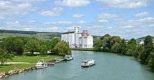
The Marne was a navigable as a free-flowing river until the 19th century. It had one gated short cut, 500m long, the Canal de Cornillon in Meaux, which was built in 1235, the oldest canal in France[3]. Canalisation was started in 1837, and completed up to Épernay in 1867. It included a number of canals bypassing the more extravagant meanders[4].
Navigation
During the heyday of canal transportation, the Marne was a major artery connecting Paris and the Seine with major rivers to the east: the Meuse (via the Canal de l'Aisne à la Marne and the Canal des Ardennes), the Moselle and the Rhine (via the Marne-Rhine Canal), and the Saône and Rhône (via the Canal de la Marne à la Saône). To facilitate transportation along the Marne itself, a number of lateral canals were constructed alongside. The most extensive was the Canal latéral à la Marne, which runs 67 km (42 mi) between Vitry-le-François and Dizy. Downstream of this were several more, including the Canal de Meaux à Chalifert, the Canal de Chelles, and the Canal de Saint-Maurice which ended at Charenton-le-Pont near the Marne's confluence with the Seine.[5] Furthermore, a portion of the Canal de l'Ourcq also runs parallel and quite close to the Marne before swinging away to enter Paris from the north; at one time the two were linked by a "tub-boat" inclined plane near Meaux.[6]
Départements and main towns crossed
- Haute-Marne (52): Langres, Chaumont, Saint-Dizier;
- Marne (51): Vitry-le-François, Châlons-en-Champagne, Épernay;
- Aisne (02): Château-Thierry;
- Seine-et-Marne (77): Meaux, Lagny-sur-Marne, Saint-Thibault-des-Vignes, Torcy, Noisiel, Chelles;
- Seine-Saint-Denis (93): Neuilly-sur-Marne, Noisy-le-Grand, Gournay-sur-Marne, Neuilly-Plaisance;
- Val-de-Marne (94): Nogent-sur-Marne, Créteil, Charenton-le-Pont, Champigny-sur-Marne, Saint-Maur-des-Fossés, Joinville-le-Pont, Saint-Maurice, Bry-sur-Marne, Le Perreux-sur-Marne.
| Wikimedia Commons has media related to Marne River. |
References
- ↑ "The Marne in the Sandre database" (in French).
- ↑ "Apprivoiser la Marne" (in French). Archived from the original on 2006-11-24. Retrieved 2006-06-02.
- ↑ Berg, Charles. "Canal Cornillon".
- ↑ Berg, Charles. "Rivière Marne".
- ↑ http://projetbabel.org/fluvial/rica_saint-maurice-canal.htm
- ↑ "Canal de l'Ourcq description and reference".
External links
- River Marne navigation guide with maps and details of places, ports and moorings on the river, by the author of Inland Waterways of France, 8th ed., 2010, publ. Imray
- Navigation details for 80 French rivers and canals (French waterways website section)