Manticao, Misamis Oriental
| Manticao | |
|---|---|
| Municipality | |
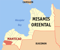
 Map of Misamis Oriental with Manticao highlighted | |
.svg.png) Manticao Location within the Philippines | |
| Coordinates: 08°23′N 124°17′E / 8.383°N 124.283°ECoordinates: 08°23′N 124°17′E / 8.383°N 124.283°E | |
| Country | Philippines |
| Region | Northern Mindanao (Region X) |
| Province | Misamis Oriental |
| District | 2nd district of Misamis Oriental |
| Founded | February 7, 1949 |
| Barangays | 13 |
| Government[1] | |
| • Mayor | Roberto M. Lagrosas |
| Area[2] | |
| • Total | 123.01 km2 (47.49 sq mi) |
| Population (2015 census)[3] | |
| • Total | 28,422 |
| • Density | 230/km2 (600/sq mi) |
| Demonym(s) | Manticaonon |
| Time zone | PST (UTC+8) |
| ZIP code | 9024 |
| IDD : area code | +63 (0)88 |
| Income class | 4th municipal income class |
| PSGC | 104318000 |
| Electorate | 18,629 voters as of 2016 |
| Website |
www |
Manticao is a fourth class municipality in the province of Misamis Oriental, Philippines. According to the 2015 census, it has a population of 28,422 people.[3]
Manticao River was known as Naawan River until 1957, when it was renamed.[4]
Geography
Manticao's geographical features consist of mountainous to flat plains to shorelines.
Barangays
Manticao is politically subdivided into 13 barangays.
- Argayoso
- Balintad
- Cabalantian
- Camanga
- Digkilaan
- Mahayahay
- Pagawan
- Paniangan
- Patag
- Poblacion
- Punta Silum
- Tuod
- Upper Malubog
Demographics
| Population census of Manticao | ||
|---|---|---|
| Year | Pop. | ±% p.a. |
| 1960 | 15,212 | — |
| 1970 | 13,503 | −1.18% |
| 1975 | 15,248 | +2.47% |
| 1980 | 17,294 | +2.55% |
| 1990 | 21,443 | +2.17% |
| 1995 | 22,630 | +1.01% |
| 2000 | 24,072 | +1.33% |
| 2007 | 25,443 | +0.77% |
| 2010 | 26,786 | +1.89% |
| 2015 | 28,422 | +1.14% |
| Source: Philippine Statistics Authority[3][5][6][7] | ||
References
- ↑ "Official City/Municipal 2013 Election Results". Intramuros, Manila, Philippines: Commission on Elections (COMELEC). 1 July 2013. Retrieved 5 September 2013.
- ↑ "Province: MISAMIS ORIENTAL". PSGC Interactive. Makati City, Philippines: National Statistical Coordination Board. Archived from the original on 1 January 1970. Retrieved 26 June 2014.
- 1 2 3 Census of Population (2015). "Region X (Northern Mindanao)". Total Population by Province, City, Municipality and Barangay. PSA. Retrieved 20 June 2016.
- ↑ "An Act Changing the Name of Naawan River in the Municipality of Manticao, Province of Misamis Oriental, to Manticao River". LawPH.com. Retrieved 2011-04-12.
- ↑ Census of Population and Housing (2010). "Region X (Northern Mindanao)". Total Population by Province, City, Municipality and Barangay. NSO. Retrieved 29 June 2016.
- ↑ Census of Population (1995, 2000 and 2007). "Region X (Northern Mindanao)". Total Population by Province, City and Municipality. NSO. Archived from the original on 24 June 2011.
- ↑ "Province of Misamis Oriental". Municipality Population Data. Local Water Utilities Administration Research Division. Retrieved 17 December 2016.
External links
- Philippine Standard Geographic Code
- Philippine Census Information
- Local Governance Performance Management System
| Adjacent places of Manticao, Misamis Oriental | ||||
|---|---|---|---|---|
 |
Naawan | El Salvador |  | |
| Iligan Bay | |
Opol | ||
| ||||
| | ||||
| Lugait / Iligan City | ||||
This article is issued from
Wikipedia.
The text is licensed under Creative Commons - Attribution - Sharealike.
Additional terms may apply for the media files.