Manston, Leeds
| Manston | |
|---|---|
 Manston Park | |
 Manston | |
| Manston shown within West Yorkshire | |
| Metropolitan borough | |
| Metropolitan county | |
| Region | |
| Country | England |
| Sovereign state | United Kingdom |
| Post town | Leeds |
| Postcode district | LS15 |
| Dialling code | 0113 |
| Police | West Yorkshire |
| Fire | West Yorkshire |
| Ambulance | Yorkshire |
| EU Parliament | Yorkshire and the Humber |
| UK Parliament | |
Manston is an area to the east of Cross Gates, Leeds, England, that lies 4 miles (6 km) to the east of Leeds city centre. It is East of the Ring Road, North of Austhorpe Road and South of Barwick Road.[1][2] The area falls within the Cross Gates and Whinmoor ward of Leeds Metropolitan Council. It is named after the former Manston estate of the Gascoigne family.[3] Many streets in the area are named after Manston, such as Manston Crescent and Manston Grove.
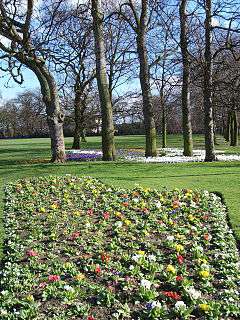
It contains Barnbow, the site of a munitions factory in both World Wars, and now a scheduled monument.[4] It has its own park, Manston Park, and had a pub named after it, the Manston hotel, which is now known as The Barnbow, next to the park. It has a Parish Church, St James the Great,[5] and is also home to three primary schools, Manston Primary, Manston St James Primary Academy and St Theresa's Catholic Primary.
.jpg) St James Church
St James Church The Vickers works, formerly Barnbow Royal Ordnance Factory
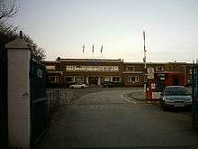 The old Optare bus factory in Manston
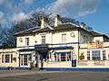 The Manston public house, now called The Barnbow
References
- ↑ www.leeds.gov.uk East Leeds Extension Indicative Plan
- ↑ AZ Leeds and Bradford Street Atlas, Geographer's A-Z Map Company, London, 1993
- ↑ Leodis Aerial View, Manston, showing Royal Ordnance Factory Barnbow
- ↑ BBC News 10 October 2016 Barnbow munitions blast factory site given heritage status
- ↑ /www.stjamesmanston.church
External links
- The Ancient Parish of Whitkirk at GENUKI: Manston was in this parish