Mangatarem, Pangasinan
| Mangatarem | ||
|---|---|---|
| Municipality | ||
 | ||
| ||
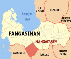 Map of Pangasinan showing the location of Mangatarem | ||
.svg.png) Mangatarem Location within the Philippines | ||
| Coordinates: 15°47′N 120°18′E / 15.783°N 120.300°ECoordinates: 15°47′N 120°18′E / 15.783°N 120.300°E | ||
| Country |
| |
| Region | Ilocos (Region I) | |
| Province | Pangasinan | |
| District | 2nd district of Pangasinan | |
| Founded | 1837 | |
| Barangays | 82 | |
| Government[1] | ||
| • Mayor | Balong Ventenilla | |
| • Vice Mayor | Teodoro C. Cruz | |
| • Electorate | 44,564 voters (2016 election) | |
| Area[2] | ||
| • Total | 317.50 km2 (122.59 sq mi) | |
| Population (2015 census)[3] | ||
| • Total | 73,241 | |
| • Density | 230/km2 (600/sq mi) | |
| Time zone | PST (UTC+8) | |
| ZIP code | 2413 | |
| PSGC | 015527000 | |
| IDD : area code | +63 (0)75 | |
| Income class | 1st municipal income class | |
| Revenue | ₱ 23,540,761.00 (2016)[4] | |
| Poverty incidence | 10.62 (2012)[5] | |

Mangatarem (Pangasinan: Baley na Mangatarem; Ilocano: Ili ti Mangatarem) is a 1st class municipality in the province of Pangasinan, Philippines. According to the 2015 census, it has a population of 73,241 people.[3]

Mangatarem Town Hall
Mangatarem is a Pangasinan word for "mango plantation" The town's name also came from the Ilocano Phrase which means "mango and oyster".[6]
The municipality is home to the Manleluag Spring Protected Landscape.
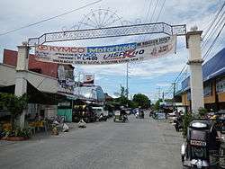
Tourism
Barangays
Mangatarem is politically subdivided into 82 barangays.
- Andangin
- Arellano Street (Pob.)
- Bantay
- Bantocaling
- Baracbac
- Peania Pedania (Bedania)
- Bogtong Bolo
- Bogtong Bunao
- Bogtong Centro
- Bogtong Niog
- Bogtong Silag
- Buaya
- Buenlag
- Bueno
- Bunagan
- Bunlalacao
- Burgos Street (Pob.)
- Cabaluyan 1st
- Cabaluyan 2nd
- Cabarabuan
- Cabaruan
- Cabayaoasan
- Cabayugan
- Cacaoiten
- Calumboyan Norte
- Calumboyan Sur
- Calvo (Pob.)
- Casilagan
- Catarataraan
- Caturay Norte
- Caturay Sur
- Caviernesan
- Dorongan Ketaket
- Dorongan Linmansangan
- Dorongan Punta
- Dorongan Sawat
- Dorongan Valerio
- General Luna (Pob.)
- Gomez (Pob.)
- Historia
- Lawak Langka
- Linmansangan
- Lopez (Pob.)
- Mabini (Pob.)
- Macarang
- Malabobo
- Malibong
- Malunec(original)
- Maravilla (Pob.)
- Maravilla-Arellano Ext. (Pob)
- Muelang
- Naguilayan East
- Naguilayan West
- Nancasalan
- Niog-Cabison-Bulaney
- Olegario-Caoile (Pob.)
- Olo Cacamposan
- Olo Cafabrosan
- Olo Cagarlitan
- Osmeña (Pob.)
- Pacalat
- Pampano
- Parian
- Paul
- Pogon-Aniat
- Pogon-Lomboy (Pob.)
- Ponglo-Baleg
- Ponglo-Muelag
- Quetegan (Pogon-Baleg)
- Quezon (Pob.)
- Salavante
- Sapang
- Sonson Ongkit
- Suaco
- Swag
- Tagac
- Takipan
- Talogtog
- Tococ Barikir
- Torre 1st
- Torre 2nd
- Torres Bugallon (Pob.)
- Umangan
- Zamora (Pob.)
Demographics
| Population census of Mangatarem | ||
|---|---|---|
| Year | Pop. | ±% p.a. |
| 1903 | 12,895 | — |
| 1918 | 15,971 | +1.44% |
| 1939 | 18,658 | +0.74% |
| 1948 | 20,425 | +1.01% |
| 1960 | 28,931 | +2.94% |
| 1970 | 35,080 | +1.94% |
| 1975 | 37,604 | +1.40% |
| 1980 | 40,582 | +1.54% |
| 1990 | 47,714 | +1.63% |
| 1995 | 53,603 | +2.20% |
| 2000 | 60,943 | +2.79% |
| 2007 | 65,366 | +0.97% |
| 2010 | 69,969 | +2.51% |
| 2015 | 73,241 | +0.87% |
| Source: Philippine Statistics Authority[3][7][8][9] | ||
Climate
| Climate data for Mangatarem, Pangasinan | |||||||||||||
|---|---|---|---|---|---|---|---|---|---|---|---|---|---|
| Month | Jan | Feb | Mar | Apr | May | Jun | Jul | Aug | Sep | Oct | Nov | Dec | Year |
| Average high °C (°F) | 31 (88) |
32 (90) |
33 (91) |
34 (93) |
33 (91) |
33 (91) |
31 (88) |
30 (86) |
31 (88) |
32 (90) |
32 (90) |
31 (88) |
31.9 (89.5) |
| Average low °C (°F) | 22 (72) |
23 (73) |
24 (75) |
25 (77) |
25 (77) |
25 (77) |
25 (77) |
25 (77) |
24 (75) |
24 (75) |
24 (75) |
23 (73) |
24.1 (75.3) |
| Average precipitation mm (inches) | 9 (0.35) |
11.4 (0.449) |
11.1 (0.437) |
5.4 (0.213) |
258 (10.16) |
315.6 (12.425) |
463.1 (18.232) |
663.2 (26.11) |
479.7 (18.886) |
121.9 (4.799) |
75.8 (2.984) |
16.8 (0.661) |
2,431 (95.706) |
| Average rainy days | 4 | 3 | 2 | 2 | 12 | 15 | 19 | 21 | 18 | 12 | 9 | 5 | 122 |
| Source: World Weather Online[10] | |||||||||||||
References
- ↑ "Municipalities". Quezon City, Philippines: Department of the Interior and Local Government. Archived from the original on 25 January 2013. Retrieved 26 November 2012.
- ↑ "Province: PANGASINAN". PSGC Interactive. Makati City, Philippines: National Statistical Coordination Board. Archived from the original on 14 November 2012. Retrieved 26 November 2012.
- 1 2 3 Census of Population (2015). "Region I (Ilocos Region)". Total Population by Province, City, Municipality and Barangay. PSA. Retrieved 20 June 2016.
- ↑ "Pangasinan : Cities and Municipalities Competitiveness Index". Makati City, Philippines: National Competitiveness Council (Philippines). Archived from the original on 28 January 2017. Retrieved 28 January 2017.
- ↑ "PSA Releases the 2012 Municipal and City Level Poverty Estimates". Quezon City, Philippines: Philippine Statistics Authority. Retrieved 28 January 2017.
- ↑ "Mangatarem". Cities and Municipalities. Province of Pangasinan. Retrieved 26 November 2012.
- ↑ Census of Population and Housing (2010). "Region I (Ilocos Region)". Total Population by Province, City, Municipality and Barangay. NSO. Retrieved 29 June 2016.
- ↑ Census of Population (1995, 2000 and 2007). "Region I (Ilocos Region)". Total Population by Province, City and Municipality. NSO. Archived from the original on 24 June 2011.
- ↑ "Province of Pangasinan". Municipality Population Data. Local Water Utilities Administration Research Division. Retrieved 17 December 2016.
- ↑ "Mangatarem, Pangasinan: Average Temperatures and Rainfall". World Weather Online. Retrieved 12 October 2015.
External links
| Wikimedia Commons has media related to Mangatarem, Pangasinan. |
- Municipal Profile at the National Competitiveness Council of the Philippines
- Mangatarem at the Pangasinan Government Website
- Local Governance Performance Management System
- Philippine Standard Geographic Code
- Philippine Census Information
- Pangasinan.org : Mangatarem Family and School Reunion Archives
Adjacent places of Mangatarem, Pangasinan | |||
|---|---|---|---|
 | | ||
Lingayen (capital) | |
| Municipalities |
|
| Component cities | |
| Independent component city |
|
| Barangays | |
This article is issued from
Wikipedia.
The text is licensed under Creative Commons - Attribution - Sharealike.
Additional terms may apply for the media files.