Malyn Raion
| Malyn Raion Малинський район | ||
|---|---|---|
| Raion | ||
| ||
 | ||
| Coordinates: 50°49′41″N 29°2′12″E / 50.82806°N 29.03667°ECoordinates: 50°49′41″N 29°2′12″E / 50.82806°N 29.03667°E | ||
| Country |
| |
| Region | Zhytomyr Oblast | |
| Admin. center | Malyn | |
| Subdivisions |
List
| |
| Area | ||
| • Total | 1,406 km2 (543 sq mi) | |
| Population (2013) | ||
| • Total |
| |
| Time zone | EET (UTC+2) | |
| • Summer (DST) | EEST (UTC+3) | |
| Area code | +380 | |
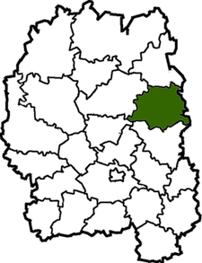
Malyn District (Raion) (Ukrainian: Малинський район) is a raion (district) of Zhytomyr Oblast, northern Ukraine. Its administrative centre is located at Malyn, which does not belong to the raion and is incorporated separately as a city of oblast significance. The raion covers an area of 1,406 square kilometres (543 sq mi). Population: 19,728 (2013 est.)[1]
Brief
It is situated in the north-eastern part of region. Distance from district (city of regional value - Malyn) to the regional center is a 102 km by highways.
Natural tourist objects
Sights of nature include: wildlife preserves “Hamarnia”, “Halove”, “Klunyshche”, “Shchuche”; Mykluko-maklai's park-sight of landscape-gardening art (all - local value). In the tract "Kyp'yache (located on the right bank of the river Irsha in four kilometers from the village Chopovychi) in scenic areas are male and female monasteries and miracle fountain are popular among the pilgrims and tourists. The rivers Teteriv, Kamyanka, Irsha with their tributaries Trostyanets, Viznya have recreational value. Malyn's quarry is popular among climbers of Kyiv.
Social and historic tourist objects
There is the row of sights of architecture and town-planning: Mykolaivska church in v.Vorsivka (in 1850), St. Mykhailyvska church in v Ukrainka (end of a ХІХc.); railway station in v. Chopovychi (the end of the ХІХc.).
References
- ↑ "Чисельність наявного населення України (Actual population of Ukraine)" (in Ukrainian). State Statistics Service of Ukraine. Retrieved 21 January 2015.
