Malakhi Junction

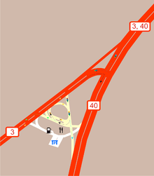
The Malakhi Junction, also known as Qastina (Hebrew: קסטינה) for the Arab village which once stood there, is a major road junction in Israel, between Highway 40 and 3. It is located on the 37th kilometer of Highway 3.
Like most junctions in Israel, it serves as a major transportation hub and has a trempiada, or hitchhiking stand. Due to its proximity to Kiryat Malakhi, it is also sometimes considered Kiryat Malakhi's central bus station, operated by the Be'er Tuvia Regional Council. In that capacity however, it has been often criticized, to the point that Ynet uses a photo of the bus stations in Qastina as a stock photo for public transportation critiques. In a March 2007 survey, Ynet gave Qastina a 0/10 rating (the lowest) out of 11 bus station checked nationwide.[1] On March 1, 2008, the Israeli Channel 2 ran a similar survey, ranking Qastina lowest, with 0/3 on its three main criteria.[2]
In addition, the junction is a common stop for Israelis traveling between the north/center of the country (Haifa, Tel Aviv) to the south (Beersheba, Eilat), a fact that helps maintain several fast food and other small stores. The junction has a Better Place battery replacement station.[3]
During the October 2000 events, Arab citizens burned tires and threw rocks at passing buses at the junction.[4]
Bus lines


Following is a list of bus lines which stop in the junction's terminal.
| Line | Route | Via | Company |
|---|---|---|---|
| 24 | Kiryat Malakhi - Beit Shemesh | Kfar Menahem | Superbus |
| 140 | Kiryat Malakhi – Ashdod CBS | Beer Tuvia regional council | Afikim |
| 141 | Kiryat Malakhi – Ashdod CBS | Beer Tuvia regional council | Afikim |
| 142 | Kiryat Malakhi – Ashdod CBS | Azrikam | Afikim |
| 301 | Tel Aviv CBS – Ashkelon CBS | Rishon LeZion old CBS, Rehovot CBS, Gedera CBS, Malakhi Junction, Kiryat Gat CBS | Egged |
| 310 | Tel Aviv CBS – Ashkelon CBS | Yavne CBS, Malakhi Junction, Kiryat Gat CBS | Egged |
| 348 | Ashdod CBS – Beersheba CBS | Malakhi Junction, Kiryat Gat CBS | Metropoline |
| 367 | Rishon LeZion CBS – Beersheba CBS | Rehovot CBS, Gedera CBS, Malakhi Junction, Kiryat Gat CBS | Metropoline |
| 369 | Tel Aviv CBS – Beersheba CBS | Yavne CBS, Malakhi Junction, Kiryat Gat CBS | Metropoline |
| 371 | Rishon LeZion CBS – Beersheba CBS | Rehovot CBS, Gedera CBS, Malakhi Junction, Kiryat Gat CBS | Metropoline |
| 376 | Tel Aviv CBS – Tze'elim | Gedera CBS, Malakhi Junction, Kiryat Gat CBS, Ofakim | Dan BaDarom |
| 389 | Tel Aviv CBS – Arad | Malakhi Junction | Egged |
| 393 | Tel Aviv CBS – Eilat CBS | Rishon LeZion old CBS, Rehovot CBS, Gedera CBS, Malakhi Junction, Beersheba CBS, Dimona CBS | Egged |
| 3941 | Eilat CBS – Tel Aviv CBS | Dimona CBS, Beersheba CBS, Malakhi Junction | Egged |
| 3951 | Mitzpe Ramon – Tel Aviv CBS | Beersheba CBS, Malakhi Junction | Egged |
| 437 | Jerusalem CBS – Ashkelon CBS | Malakhi Junction | Egged |
| 443 | Jerusalem CBS – Netivot | Malakhi Junction, Sderot | Egged |
| 446 | Jerusalem CBS – Beersheba CBS | Malakhi Junction, Kiryat Gat CBS | Egged |
| 449 | Ofakim – Jerusalem CBS1 2 | Kiryat Gat CBS – Malakhi Junction | Egged |
| 991 | Eilat CBS – Haifa Hof HaCarmel CBS1 | Netanya CBS, Hadera CBS | Egged |
1 – stops in the terminal in one direction only
2 – Sundays only
Road accidents
In the beginning of 2010, Ayelet Malko suffered fatal injuries after being run over while crossing the junction. This contributed to a decision to build a pedestrian bridge in the area, which was planned to have been completed by the end of 2010.[5]
Plans
The National Roads Company of Israel approved 500 million NIS to upgrade the junction to an interchange.[5]
See also
References
- ↑ Donner, Shlomi (2007-03-09). "A Check on Central Bus Stations - Third World Level" (in Hebrew). Ynet.
- ↑ "A Journey to the Past - The State of the Central Bus Stations in Israel (video)" (in Hebrew). 2008-03-01. Retrieved 2008-03-01.
- ↑ "Better Place Completes Battery Exchange Network". Globes. August 22, 2012. Retrieved August 26, 2012.
- ↑ "October 2000 events timeline" (in Hebrew). Israel Court Protocols. Retrieved 2008-04-15.
- 1 2 Jan, Eli (June 9, 2010). "Interchange for Qastina Junction Approved". Mynet (in Hebrew). Ynet. Retrieved 2010-07-24.
Coordinates: 31°43′54.67″N 34°45′24.53″E / 31.7318528°N 34.7568139°E