Chennai district
Coordinates: 13°5′2″N 80°16′12″E / 13.08389°N 80.27000°E
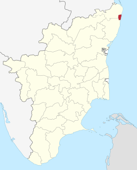
Chennai district, formerly known as Madras district or "Madarasapattinam", is a district in the state of Tamil Nadu, in India. It is the smallest of all the districts in the state, but has the highest human density. The district is a city district which means that it does not have a district headquarters. Most of the Greater Chennai City comes under this district, erstwhile under Kancheepuram and Tiruvallur districts . As of 2011, the district had a population of 4,646,732 with a sex-ratio of 989 females for every 1,000 males.
Geography
Chennai district covers an area of 178.2 km2 located on the Eastern Coastal Plains of India. It is situated on the northeastern corner of Tamil Nadu along the Coramandel coast, a region bounded by the Bay of Bengal and is surrounded inland by the districts of Tiruvallur and Kanchipuram. It lies between 12°59' and 13°9' of the northern latitude and 80°12' and 80°19' of the eastern longitude at an average altitude of 6 metres above sea level on a 'sandy shelving breaker swept' beach. Terrain slope varies from 1:5000 to 1:10,000.[1] The terrain is very flat with contours ranging from 2 m to 10 m above mean sea level with a few isolated hillocks in the southwest beyond the district limits at St. Thomas Mount, Pallavaram and Tambaram.[2] The district runs inland in a rugged semi-circular fashion and its coastline is about 25.60 km (2.5% of the total coastline of Tamil Nadu). Because of its strategic location and economic importance, it is referred to as the "Gateway of South India." The drainage system includes two rivers, namely, Cooum (flowing in the northern part) and Adyar (flowing in the southern part), a canal (the Buckingham), and a stream (the Otteri Nullah) slicing the district into several islands.
The district falls under Seismic Zone III indicating a moderate risk of earthquake. Geologically the district is divided into three regions, namely, sandy, clayey and hard-rock regions. The soil comprises clay, shale and sandstone.[3]
Of the total land area, reserved forests cover 2.71 km2 and is concentrated in and around the Guindy National Park region, one of the few national parks in the world located within a city. The forest cover of the district is as follows:[4]
| Class | Area (Ha) | Percentage |
|---|---|---|
| Dense forest | 151.01 | 1.16 |
| Moderate dense TOF | 121.16 | 0.93 |
| Non-forest | 12,215.56 | 94.06 |
| Open forest | 114.24 | 0.88 |
| Open TOF | 153.73 | 1.18 |
| Water | 231.46 | 1.78 |
| Total | 12,987.16 | 100 |
Climate
| Climate data for Chennai, India | |||||||||||||
|---|---|---|---|---|---|---|---|---|---|---|---|---|---|
| Month | Jan | Feb | Mar | Apr | May | Jun | Jul | Aug | Sep | Oct | Nov | Dec | Year |
| Record high °C (°F) | 33 (91) |
37 (99) |
39 (102) |
43 (109) |
45 (113) |
43 (109) |
41 (106) |
40 (104) |
39 (102) |
39 (102) |
34 (93) |
33 (91) |
45 (113) |
| Average high °C (°F) | 29 (84) |
31 (88) |
33 (91) |
35 (95) |
38 (100) |
38 (100) |
36 (97) |
35 (95) |
34 (93) |
32 (90) |
29 (84) |
29 (84) |
33.3 (91.8) |
| Average low °C (°F) | 19 (66) |
20 (68) |
22 (72) |
26 (79) |
28 (82) |
27 (81) |
26 (79) |
26 (79) |
25 (77) |
24 (75) |
22 (72) |
21 (70) |
23.8 (75) |
| Record low °C (°F) | 14 (57) |
15 (59) |
17 (63) |
20 (68) |
21 (70) |
21 (70) |
22 (72) |
21 (70) |
21 (70) |
17 (63) |
15 (59) |
14 (57) |
14 (57) |
| Average precipitation mm (inches) | 16.2 (0.638) |
3.7 (0.146) |
3.0 (0.118) |
13.6 (0.535) |
48.9 (1.925) |
53.7 (2.114) |
97.8 (3.85) |
149.7 (5.894) |
109.1 (4.295) |
282.7 (11.13) |
350.3 (13.791) |
138.2 (5.441) |
1,266.9 (49.878) |
| Source: Indian Meteorological Department[5] | |||||||||||||
Demographics
| Assembly Constituency |
Political Party |
Elected Representative |
|---|---|---|
| Royapuram | AIADMK | D. Jayakumar |
| Harbour | DMK | Sekhar babu |
| Dr. Radhakrishnan Nagar | TBA | TBA |
| Thiru. Vi. Ka Nagar | DMK | Thayagam kavi |
| Virugampakkam | DMK | B. Parthasarathy |
| Perambur | CPIM | A. Soundararajan |
| Kolathur | DMK | M. K. Stalin |
| Egmore | DMK | Ravichandiran K S |
| Anna Nagar | DMK | Mohan |
| Villivakkam | DMK | B Ranganathan |
| Thiyagaraya Nagar | AIADMK | V. P. Kalairajan |
| Thousand Lights | DMK | Selvan ku.ka |
| Chepauk-Thiruvallikeni | DMK | J. Anbazhagan |
| Velachery | DMK | Vaagai Chandrasekar |
| Mylapore | AIADMK | R. Nataraj |
| Saidapet | DMK | maa.subramanian |
| Source: Office of the CEO, Tamil Nadu.[6] | ||
| Lok Sabha Constituency |
Political Party |
Elected Representative |
|---|---|---|
| Chennai North | AIADMK | Venkatesh babu |
| Chennai South | AIADMK | C. Rajendran |
| Chennai Central | AIADMK | S R VIJAYAKUMAR |
| Source: Indian Elections / Election Commission of India.[7][8][9] | ||
According to 2011 census, Chennai district had a population of 4,646,732 with a sex-ratio of 989 females for every 1,000 males, much above the national average of 929.[10] A total of 459,324 were under the age of six, constituting 235,519 males and 223,805 females. Scheduled Castes and Scheduled Tribes accounted for 16.78% and .22% of the population respectively. The average literacy of the district was 81.27%, compared to the national average of 72.99%.[10] The district had a total of 154,982 households. There were a total of 1,817,297 workers, comprising 10,210 cultivators, 10,251 main agricultural labourers, 29,143 in house hold industries, 1,569,950 other workers, 197,743 marginal workers, 4,244 marginal cultivators, 3,423 marginal agricultural labourers, 8,202 marginal workers in household industries and 181,874 other marginal workers.[11]
Administration and politics
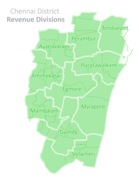
In December 2013, the district was divided into ten taluks,[12] namely,
- Aminjikarai taluk
- Ayanavaram taluk
- Egmore taluk
- Guindy taluk
- Mambalam taluk
- Mylapore taluk
- Perambur taluk
- Purasaiwalkam taluk
- Tondiarpet taluk
- Velachery taluk
Historical events
- 1639 Madras founded .The English get Madras Patnam from Ayyapa Naicker.
- 1640 Francis Day and Cogan landed with 25 Europeans.Foundation laid for Fort St.George.
- 1668 Triplicane annexed to the city.
- 1678 Foundation laid for St. Mary’s Church in Fort St. George.
- 1679 St.Mary’s Church completed.
- 1688 Madras City Municipal Corporation inaugurated.
- 1693 Egmore, Purasawalkam and Tondiarpet annexed to the City.
- 1708 Thiruvottiyur, Nungambakkam, Vyasarpady, Kottivakkam and Sathangadu, Five neighbouring Villages annexed; wall built around Black Town. 1711 First Printing Press erected in Madras.
- 1735 Chintadripet was formed.
- 1742 Veperi, Perimet, Perambur and Pudupakkam annexed to the city.
- 1746 The French return Madras to the British; Santhome and Mylapore annexed to the City.
- 1758 French Commander Lawly besieges Madras.
- 1759 French siege ended.
- 1767 Hyder Ali’s first invasion.
- 1768 Chepauk palace built by Nawab of Arcot.
- 1769 Hyder Ali’s Second invasion.
- 1777 Veerappillai appointed as First Kotthawal Hence the name Kotthawal Chavadi.
- 1783 Fort St. George repaired and attains the present shape.
- 1784 The first newspaper, Madras Courier.
- 1785 First Post Office.
- 1795 Triplicane Big Mosque-Walajah Mosque built.
- 1817 Madras Literary Society founded.
- 1826 Board of Public Instructions founded.
- 1831 First commercial Bank, Madras Bank. First census: population 39,785.
- 1832 Madras Club founded.
- 1834 First Survey School inaugurated Later developed as Engineering College.
- 1835 First medical college; later became Madras Christian College.
- 1841 Ice House was built. Ice shipped from America was stored here; Later named as Vivekananda House.
- 1842 First lighthouse.
- 1846 Pachaiappan School; Later Pachaiappa’s College.
- 1851 Museum formed
- 1853 Zoo formed.
- 1855 University Board formed.
- 1856 First Railway –Royapuram to Arcot.
- 1857 Madras University founded.
- 1864–65 Presidency College built.
- 1868 Attempt to protect water supply.
- 1873 First birth registration. Madras Mail newspaper founded. Cosmopolitan Club founded.
- 1874 University Senate house built.
- 1876–78 Great Famine – Buckingham Canal dug.
- 1878 The Hindu newspaper founded.
- 1882 First telephone.
- 1885 Marina Beach Road constructed.
- 1886 Indian National Congress meet at Madras. Connemera Public Library founded.
- 1889 High Court building foundation laid.
- 1894 First Car – Mr. A.J. Boag, Director of Parry&Co, drove the Car on city roads.
- 1895 First tram.
- 1899 First Tamil newspaper-Swadesamitran.
- 1905 Port Trust formed.
- 1906 Indian Bank founded. King Institute, Guindy founded.
- 1914 Water mains and drainage formed. Street lights introduced. Kilpauk water works inaugurated. German warship Endon bombarded the sea shore and withdrew – First World War.
- 1917 First aeroplane; Simpson & Co., arranged for the trial flight.
- 1924 School of Indian Medicine.
- 1925 Loyola College, first bus.
- 1930 First broadcasting station founded at Ripon Buildings Complex.
- 1933 Inauguration of Chennai suburban Rail
- 1934 First Mayor – Raja Sir. Muthiah Chettiyar 1938 All India Radio formed and broadcasting from Ripon Buildings ceased.
- 1942 Second World War – Evacuation of Madras.
- 1943 Japanese fighter plane dropped bombs on City and withdrew. 1946 Mambalam, Saidapet, Govt. Farm, Puliyur, Kodambakkam, Saligramam, Adayar and Alandur Villages which formed part of Saidapet Municipality were annexed to the city.Sembiyam, Siruvallur, Peravallur, Small Sembarambakkam and Ayanavaram which formed part of Sembium Panchayat Board were annexed to the city. Aminjikarai, Periyakudal, Maduvankarai Villages which formed part of Aminjikarai Panchayat Board were annexed. Part of Velacheri Village belonging to Velacheri Panchayat Board was also annexed to the city.
- 1947 Indian national flag Hoisted over Fort. St. George.
- 1952 Nehru Stadium.
- 1956 Gandhi Mandap.
- 1959 Guindy Children’s Park.
- 1969 World Tamil Congress.
- 1971 Snake Park.
- 1972 Madras Metropolitan Development Authority.
- 1973 Madras Corporation superseded.
- 1974 Rajaji Mandap.Madras Television Centre.
- 1975 Kamaraj Mandap.Valluvar Kottam.
- 1975 Madras Doordarshan started.
- 1976 New Light House.
- 1977 Madras Metropolitan Water supply and Sewage Board Kanagam, Taramani, Thiruvanmiyur, Velacheri, Kodambakkam, Virugambakkam, Saligramam, Koyambedu, Thirumangalam, Villivakkam, Errukancheri, Kolathur, Kodungaiyur Panchayat areas annexed to the City;Madras reaches the present stage.
- 1983 Zoo shifted to Vandalur.
- 1988 Periyar Science Park Birla Planetarium. Madras Corporation’s Tri-centenary.Decentralisation of Administration.10 Circles formed.
See also
References
- ↑ "Session-3 River and Drainage System in CMA" (pdf). CMDA. Retrieved 30 Dec 2011.
- ↑ Chapter IX Macro Drainage System in CMA
- ↑ John, Ekatha Ann (29 September 2012). "Disaster body for panel to monitor highrises in Chennai". The Times of India. Chennai. Retrieved 25 July 2015.
- ↑ "Forest at Glance". Tamil Nadu Forest Department.
- ↑ "Climatological Information for Chennai". Indian Meteorological Department. Archived from the original on 2009-02-05. Retrieved 2009-01-25.
- ↑ "Chennai District MLA details" (PDF). Election Commission of India. Archived from the original (PDF) on 2013-04-02.
- ↑ "Election results". Indian Elections.
- ↑ "Parties Statistics". Election Commission of India. Archived from the original on 2008-12-18.
- ↑ "City Constituency post-delimitation details" (PDF). Election Commission of India.
- 1 2 "Census Info 2011 Final population totals". Office of The Registrar General and Census Commissioner, Ministry of Home Affairs, Government of India. 2013. Retrieved 26 January 2014.
- ↑ "Census Info 2011 Final population totals – Chennai district". Office of The Registrar General and Census Commissioner, Ministry of Home Affairs, Government of India. 2013. Retrieved 26 January 2014.
- ↑ Julie Mariappan (21 December 2013). "Chennai now has 10 taluks, as govt gets close to you". The Times of India.
External links
| Wikimedia Commons has media related to Chennai district. |
| State symbols |
|
|---|---|
| Governance |
|
| Topics | |
| Districts |
|
| Major cities | |
| City |  | |
|---|---|---|
| State | ||
| Region | ||
| Taluks | ||