Madalum, Lanao del Sur
| Madalum | |
|---|---|
| Municipality | |
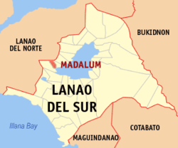
 Map of Lanao del Sur with Madalum highlighted | |
.svg.png) Madalum Location within the Philippines | |
| Coordinates: 07°51′N 124°07′E / 7.850°N 124.117°ECoordinates: 07°51′N 124°07′E / 7.850°N 124.117°E | |
| Country | Philippines |
| Region | Autonomous Region in Muslim Mindanao (ARMM) |
| Province | Lanao del Sur |
| Barangays | 37 |
| Government[1] | |
| • Mayor | Usman Sarangani Jr. |
| Area | |
| • Total | 498.39 km2 (192.43 sq mi) |
| Population (2015 census)[2] | |
| • Total | 23,127 |
| • Density | 46/km2 (120/sq mi) |
| Time zone | PST (UTC+8) |
| ZIP code | 9315 |
| IDD : area code | +63 (0)63 |
| Income class | 3rd municipal income class |
| PSGC | 153613000 |
| Electorate | 9,445 voters as of 2016 |
| Website |
www |
Madalum is a third class municipality in the province of Lanao del Sur, Philippines. According to the 2015 census, it has a population of 23,127 people.[2]
Barangays
Madalum is politically subdivided into 37 barangays.
- Abaga
- Bago a ingud
- Basak
- Bato
- Bubong
- Kormatan
- Dandamun
- Diampaca
- Dibarosan
- Dilausan
- Gadongan
- Gurain
- Cabasaran
- Cadayonan
- Liangan I
- Lilitun
- Linao
- Linuk
- Madaya
- Pagayawan
- Poblacion
- Pokilan
- Punud
- Raya
- Riray
- Sabanding
- Salongabanding
- Sugod
- Tamporong
- Tongantongan
- Udangun
- Liangan
- Lumbac
- Paridi-Kalimodan
- Racotan
- Bacayawan
- Padian Torogan I
- Sogod Koloy
Mayors after People Power Revolution 1986
- 1986 - 1989,
- 1989 - 1992, Usman Sarangani, Sr.
- 1992 - 1995, Usman Sarangani, Sr.
- 1995 - 1998, Usman Sarangani, Sr.
- 1998 - 2001, Sarangani
- 2001 - 2004, Sarangani
- 2004 - 2007, Usman Sarangani, Sr.
- 2007 - 2010, Usman Sarangani, Sr.
- 2010 - 2013, Usman Sarangani, Sr.
- 2013 - 2016, Usman Sarangani, Jr.
- 2016 present, Mrs. Sarangani,
Demographics
| Population census of Madalum | ||
|---|---|---|
| Year | Pop. | ±% p.a. |
| 1918 | 1,606 | — |
| 1939 | 3,173 | +3.30% |
| 1948 | 4,699 | +4.46% |
| 1960 | 6,523 | +2.77% |
| 1970 | 7,937 | +1.98% |
| 1975 | 10,005 | +4.75% |
| 1980 | 8,912 | −2.29% |
| 1990 | 14,747 | +5.17% |
| 1995 | 15,838 | +1.35% |
| 2000 | 18,405 | +3.27% |
| 2007 | 25,585 | +4.65% |
| 2010 | 20,243 | −8.17% |
| 2015 | 23,127 | +2.57% |
| Source: Philippine Statistics Authority[2][3][4][5] | ||
References
- ↑ "Official City/Municipal 2013 Election Results". Intramuros, Manila, Philippines: Commission on Elections (COMELEC). 1 July 2013. Retrieved 5 September 2013.
- 1 2 3 Census of Population (2015). "ARMM - Autonomous Region in Muslim Mindanao". Total Population by Province, City, Municipality and Barangay. PSA. Retrieved 20 June 2016.
- ↑ Census of Population and Housing (2010). "ARMM - Autonomous Region in Muslim Mindanao". Total Population by Province, City, Municipality and Barangay. NSO. Retrieved 29 June 2016.
- ↑ Census of Population (1995, 2000 and 2007). "ARMM - Autonomous Region in Muslim Mindanao". Total Population by Province, City and Municipality. NSO. Archived from the original on 11 November 2011.
- ↑ "Province of Lanao del Sur". Municipality Population Data. Local Water Utilities Administration Research Division. Retrieved 17 December 2016.
External links
This article is issued from
Wikipedia.
The text is licensed under Creative Commons - Attribution - Sharealike.
Additional terms may apply for the media files.
