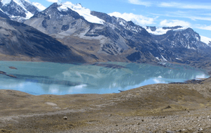
Machu Such'i Qhuchi
| Machu Such'i Qhuchi | |
|---|---|
 Machu Such'i Qhuchi (on the right) behind Such'i Lake as seen from the southeast | |
| Highest point | |
| Elevation | 5,723[1] m (18,776 ft) [2] |
| Coordinates | 14°45′S 69°12′W / 14.750°S 69.200°WCoordinates: 14°45′S 69°12′W / 14.750°S 69.200°W [2] |
| Geography | |
 Machu Such'i Qhuchi Location in Bolivia | |
| Location |
Bolivia La Paz Department, Franz Tamayo Province |
| Parent range | Andes, Apolobamba mountain range |
Machu Such'i Qhuchi or Machu Such'i Q'uchi (a combination of Quechua and Aymara, machu old,[3] such'i a species of pencil catfish,[4][5] qhuchi or q'uchi wetlands[6][7] "old such'i wetlands", hispanicized spellings Machu Suchi Cuchi, Matchu Suchi Cuchi, Machu Suchi Coochi, Matchu Sochi Conchi) is a mountain in the Apolobamba mountain range in the Bolivian Andes, about 5,679 metres (18,632 ft) high.[8] It is situated near the Peruvian border in the La Paz Department, Franz Tamayo Province, Pelechuco Municipality, east of Such'i Lake.[9]

Map of the Apolobamba mountain range showing Lake Suches. Machu Such'i Qhuchi is situated east of it.
See also
References
- ↑ John Biggar, The Andes: A Guide for Climbers, p. 126
- 1 2 "Matchu Sochi Conchi". mapcarta.com. Retrieved 2012-11-29.
- ↑ Teofilo Laime Ajacopa, Diccionario Bilingüe Iskay simipi yuyayk'ancha, La Paz, 2007 (Quechua-Spanish dictionary)
- ↑ Ulpian Ricardo López García, Diversidad Biológica y lenguas del altiplano de Oruro: Metamorfosis de la lengua uru y resistenia a los cambios (Spanish), p. 372: Castellano: Suche - denominación cientifica: Trichomycterus dispar - aimara: Such'i
- ↑ katari.org Aymara-Spanish dictionary
- ↑ aymara.ucb.edu.bo Félix Layme Pairumani, Spanish-Aymara dictionary
- ↑ Claudette Kemper Columbus, Madre-padre-criatura: el dios andino transcorriente, Wiracocha, p. 61
- ↑ www.andes.org.uk / Antikunapi 5.500 m - 6.000 m urqukuna
- ↑ John Biggar, The Andes: A Guide for Climbers (see map)
This article is issued from
Wikipedia.
The text is licensed under Creative Commons - Attribution - Sharealike.
Additional terms may apply for the media files.