MAX Yellow Line
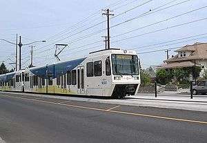
The MAX Yellow Line is a 5.8-mile (9.3 km) (not including segments downtown shared with other lines) route in the Metropolitan Area Express light rail system in Portland, Oregon. The route, which opened May 1, 2004,[2] runs between Portland State University (PSU), in downtown Portland, and the Portland Expo Center. It is also known as the Interstate MAX because the majority of the line runs along Interstate Avenue in North Portland.
History
The Yellow Line was originally conceived as part of a north-south light rail project between Vancouver, Washington, and Milwaukie to be built using city funds, but that plan was rejected by voters. TriMet then learned that a majority of the residents of North Portland had voted in favor of the original plan, so they decided to build this new line without using city funds. To do this, they convinced the City of Portland to create an urban renewal district along the proposed line, which made them eligible for matching federal funds with which they could finance the construction of the MAX line. The project was finished four months ahead of schedule at a budget of $350 million, $25 million under budget.[2] The presence of the line has also caused a great deal of redevelopment along its corridor.[3] The line originally followed First Avenue and Morrison and Yamhill streets in downtown, terminating at Galleria/Southwest 10th Avenue station. However, on August 30, 2009, it was rerouted to use new tracks on the rebuilt Portland Transit Mall and now ends at PSU.[4]
Plans
There have been plans for extensions at both ends. The Portland–Milwaukie Light Rail project extended the MAX system from the current PSU terminus, on the Portland Transit Mall couplet, across the Willamette River east via the Tilikum Crossing, then southward to Milwaukie via a Union Pacific Railroad right-of-way and SE McLoughlin Boulevard. Though planned as a Yellow Line extension, it opened on September 12, 2015 as the Orange Line.
In current service, the Yellow Line is partially interlined with the Orange Line. Upon arrival at Union Station, southbound Yellow Line trains become Orange Line trains, then travel the length of the Transit Mall, and continue south to Milwaukie. In the reverse direction, northbound Orange Line trains become Yellow Line trains upon arrival at the PSU South stations. Some Orange Line trains terminate at Union Station during peak hours. This is due to higher projected ridership along the Orange Line than the Yellow Line.[5]
The Columbia River Crossing project would have extended the Yellow Line north from Expo Center across the Columbia River to Clark College via Interstate 5, Washington/Broadway Street couplet, and East McLoughlin Blvd. Stops would have served Hayden Island and Vancouver, Washington.
Stations
References
- ↑ "April 2017 Monthly Performance Report" (PDF). TriMet. Retrieved July 3, 2017.
- 1 2 Hamilton, Don (April 30, 2004). "Making tracks to the MAX". Portland Tribune. Archived from the original on March 31, 2012. Retrieved 2014-08-08.
- ↑ US Light Rail Transit Has Sudden Growth Spurt - Light Rail Now • May 2004
- ↑ "New MAX line opens downtown". Portland Tribune. August 28, 2009. Archived from the original on June 8, 2011. Retrieved 2014-08-08.
- ↑ Lum, Brian (June 19, 2015). "You Asked: How Will the MAX Orange Line Work in Downtown Portland?". How We Roll. TriMet. Retrieved 2015-06-20.
External links
- TriMet homepage
- Interstate MAX Yellow Line Project History (brief summary) on TriMet website
