Lucinda, Queensland
| Lucinda Queensland | |||||||||
|---|---|---|---|---|---|---|---|---|---|
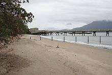
 Jetty | |||||||||
 Lucinda | |||||||||
| Coordinates | 18°31′S 146°20′E / 18.517°S 146.333°ECoordinates: 18°31′S 146°20′E / 18.517°S 146.333°E | ||||||||
| Population | 448 (2006 census)[1] | ||||||||
| Postcode(s) | 4850 | ||||||||
| Elevation | 10 m (33 ft)[2] | ||||||||
| Location |
| ||||||||
| LGA(s) | Hinchinbrook Shire Council | ||||||||
| State electorate(s) | Hinchinbrook | ||||||||
| Federal Division(s) | Kennedy | ||||||||
| |||||||||

Lucinda is a coastal town in the state of Queensland, Australia, located at the southern entrance to Hinchinbrook Channel near the town of Ingham. A sugar-exporting town, Lucinda is noted for its 6 km-long sugar jetty, the world's largest bulk sugar loading facility.[3] At the 2006 census, Lucinda had a population of 448.[1]
Lucinda is serviced by a convenience store, the Hinchinbrook Marine Cove Resort[4] on the waterfront on Dungeness Road, the Wanderers Village Resort on Bruce Parade and a hotel on Lucinda Point Road. It is also frequently serviced by Ingham and the nearby town of Halifax. Lucinda is serviced 5 days a week by Australia Post
Lucinda is located in the Hinchinbrook Shire local government area.
Lucinda is also used as a port for a supply barge to Palm Island.
History
Lucinda Post Office opened on 6 October 1896.[5]
References
- 1 2 Australian Bureau of Statistics (25 October 2007). "Lucinda (L) (Urban Centre/Locality)". 2006 Census QuickStats. Retrieved 2008-07-05.
- ↑ Bureau of Meteorology. Retrieved on 2008-07-05.
- ↑ Hinchinbrook Tourism site - Lucinda page. Retrieved 16 December 2006.
- ↑ http://hinchinbrook-marine-cove-resort.com.au/. Missing or empty
|title=(help); External link in|website=(help); - ↑ Premier Postal History. "Post Office List". Premier Postal Auctions. Retrieved 10 May 2014.