Lower Dir District
| Lower Dir District ضلع دیر | |
|---|---|
| District | |
 | |
| Country | Pakistan |
| Province | Pakhtunkhwa |
| Religion | Islam |
| Headquarters | Timergara |
| Area | |
| • Total | 1,582 km2 (611 sq mi) |
| Population (1998)[1]:25 | |
| • Total | 717,650 |
| • Density | 450/km2 (1,200/sq mi) |
| Time zone | PST |
| Main language | Pashto (99.4)[1]:27 |
| Website | http://www.lowerdir.pk/ |
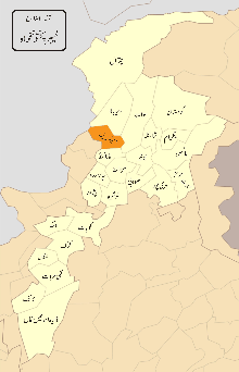
Lower Dir (Pashto: لر دیر ,Urdu: دیر زیریں) is one of the 26[2] districts in the Khyber Pakhtunkhwa province of Pakistan. Timergara city is the district headquarters and largest city.
At the time of independence, Dir was a state ruled by Nawab Shah Jehan Khan. It was merged in Pakistan in 1969 and later on declared a district in 1970. The district was formed in 1996, when the district of Dir was divided into Upper Dir and Lower Dir. The District borders with Swat District on its East, Afghanistan on its West, Upper Dir and Chitral on its North & north-west respectively and Malakand and Bajaur Agency on its South.
History
The history of Dir dates back to at least the 2"d millennium BC, testified by the excavations from 18th to 6th century BC of numerous burials of Aryans at Timergara and other places. The Aryans followed by the Achaemenians, were ousted by the invasion of Alexander in 327 BC. The area witnessed the Gandharan Civilization after the Greeks. This period is signified by the presence of the Buddhist stupas and monasteries.
Pilgrims and historians have defined Gandhara, as "the area to the west of Indus and north of Kabul rivers which included the valleys of Peshawar, Swat, Dir and Bajaur, extending westwards to Hadda and Bamiyan in Afghanistan and Taxila Valley in Punjab in the east". Dir therefore offers unique collection of Gandharan Art some of which are at Dir Museum in Chakdara.
The Yousafzai Pathans established themselves here in the 5th century AD. The British annexed Dir in 1897 and demarcated its boundaries. After independence of Pakistan, it enjoyed the status of a separate state, but was amalgamated with Pakistan in 1960 as a tribal agency.
The British Raj honored Muhammad sharif Khan as Nawab of Dir in 1898 . By declaring his allegiance to the British Raj, Khan/Nawab, once exiled to Afghanistan by Umara Khan Mastkhel was seated as Nawab of Dir. He was succeed by his son Nawab Aurang Zeb in 1904, who ruled until his death in 1925. His son Sir Shah Jehan succeeded him and ruled the state for 35 long years. He was dethroned and kept in house arrest in Lahore until his death in 1966 . He was succeeded by Mohammad Shah Khisro Khan. He left all the business at the mercy of his advisor, a man deputed by the Govt:of Pakistan to mould the state into a settled district through gradual implementation of laws. In 1969, it was merged as a district with Khyber Pakhtunkhwa. In 1996, Dir District was divided into two districts-Lower and Upper Dir- with Timergara and Dir as their respective headquarters.
Geography
District Lower Dir is located in the north-western part of Khyber Pakhtunkhwa province and is spread over an area of 1583 square kilometers. Most of the state layed in the valley of the Panjkora river, which originates in the Hindu Kush mountains and joins the Swat River near Chakdara. Apart from small areas in the south-west, Dir is a rugged, mountainous zone with peaks rising to 5,000 metres (16,000 ft) in the north-east and to 3,000 metres (9,800 ft) along the watersheds, with Swat to the east and Afghanistan and Chitral to the west and north.
The topography of the district is dominated by the mountains and hills which are part of the ranges/branches of southern Hindukush with the highest peaks in the northern part of Dir. The major valleys of Lower Dir include; Timergara, Jandool Maidan, Samarbagh, and Asban.
Demographics
The population of the Lower Dir district is 797,852 according to the 1998 census report. The projected population of Dir Lower was 1.037.091 in 2005 with the same growth between the 1981 and 1998 census i.e. 3.42% per annum. The projected male population of Dir lower in 2005 is 514,072 and the female is 523,020.
The literacy ratio of the district among the population aged 10 years and above is 29.90 percent which has increased significantly since 1981 when it was just 10.16 percent. The male literacy ratio is higher i.e. 48.76 compared to 12.25 percent for females, according to census report 1998.
Tourist Places


Laram Top also known as "Laram Sar" is a hill station in the Lower Dir District at a distance of 30 km from Chakdara. It is located at elevation of 8500 ft above the sea level, surrounded by mountains and trees. The Top receives heavy snowfall during winter season and attracts tourists.
Jakar Baba Top is another hill station in the Lower Dir District of Khyber Pakhtunkhwa, Pakistan. It is encircled by Pine trees.
The place is located at a distance of 16 km from the Asbanr village and can be approached from this village in a four-wheel drive vehicle. Shahi top, near the Afghanistan border. It has a rest house facility though it is often not open to the public.
Administration

The district is administratively subdivided into seven tehsils, Adenzai, Timergara, Balambat, Khall, Munda, Samar Bagh and Lal Qila Maidan, which contain a total of 41 Union Councils.[3] In Lower Dir, there are 7 tehsils:
| Tehsil | Union councils |
|---|---|
| Adanzai |
Asbanr, Badwan, Chakdara, Khadagzai, Khanpur, Kotigram, Ouch |
| Balambat |
Balambat, Hayaserai, Lajbook, Munjai, Koto, Rabat |
| Khall | |
| Lal Qila Maidan |
Bishgram, Lal Qilla, Gall Maidan, Kotkai (Maidan), Zaimdara, |
| Munda |
Khazana, Mia Kalai, Munda, |
| Samar Bagh |
Darangai, Kambat, Mayar, Maskini, Sadbar Kali, Samar Bagh |
| Timergara |
Bagh Dush Khel, Bandagai, Khungai, Malak Abad Ghara, Noora Khel, Shahi Khel Ziarat Talash, Timergara (Urban) |
National Assembly
This district is represented by one elected MNA (Member of National Assembly) in Pakistan National Assembly. Its constituency is NA-34.[4]
| Member of National Assembly | Party Affiliation | Year |
|---|---|---|
| Qazi Hussain Ahmad | Muttahida Majlis-e-Amal | 2002 |
| Maulana Ahmad Ghafoor Ghawas | Muttahida Majlis-e-Amal | 2003 |
| Malak Azmat Khan | Pakistan Peoples Party | 2008 |
| Shahib Zada Muhammad Yaqub | Jamaat-e-Islami Pakistan | 2013 |
Qazi Hussain Ahmad won the general elections in 2002 but he left the seat as he had also won from his native constituency. Therefore, in January 2003 bye-elections were held.
Provincial Assembly
The district is represented by four elected MPAs in the provincial assembly who represent the following constituencies, after shifting of three union council from the Upper Dir to Lower Dir the provincial constituency of upper Dir, PF-93 now consists of UCs Khall, Toor Mang and Akha Gram of Lower Dir :[5]
Notable people
Gallery
| Wikimedia Commons has media related to Lower Dir District. |
See also
References
- 1 2 1998 District Census report of Lower Dir. Census publication. 31. Islamabad: Population Census Organization, Statistics Division, Government of Pakistan. 1999.
- ↑ http://www.dawn.com/news/1080683
- ↑ Tehsils & Unions in the District of Lower Dir - Government of Pakistan
- ↑ http://ecp.gov.pk/GE.aspx
- ↑ Constituencies and MPAs - Website of the Provincial Assembly of the Khyber-Pakhtunkhwa
External links
Coordinates: 34°51′N 71°51′E / 34.850°N 71.850°E


