Lossatal
| Lossatal | |
|---|---|
 Lossatal | |
Location of Lossatal within Leipzig district 
 | |
| Coordinates: 51°24′N 12°52′E / 51.400°N 12.867°ECoordinates: 51°24′N 12°52′E / 51.400°N 12.867°E | |
| Country | Germany |
| State | Saxony |
| District | Leipzig |
| Government | |
| • Mayor | Uwe Weigelt |
| Area | |
| • Total | 110.81 km2 (42.78 sq mi) |
| Elevation | 144 m (472 ft) |
| Population (2015-12-31)[1] | |
| • Total | 6,064 |
| • Density | 55/km2 (140/sq mi) |
| Time zone | CET/CEST (UTC+1/+2) |
| Postal codes | 04808 |
| Dialling codes | 034262 |
| Vehicle registration | L |
| Website | www.lossatal.eu |
Lossatal is a municipality in the Leipzig district in Saxony, Germany, created with effect from 1 January 2012 by the merger of Hohburg and Falkenhain.[2]

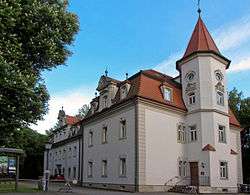
Dornreichenbach castle
Local council
[3] Elections in May 2014:
- CDU: 8 seats
- Bürger Für Lossatal (BFL): 4 seats
- The Left: 3 seats
- Unabhängige Wählervereinigung Falkenhain e. V. (UWV): 1 seat
- SPD: 1 seat
- Freie Wählervereinigung Hohburg e. V. (FWVH): 1 seat
Mayor
Uwe Weigelt was elected mayor in March 2012 with 71% of the votes.[4]
References
- ↑ "Aktuelle Einwohnerzahlen nach Gemeinden 2015] (Einwohnerzahlen auf Grundlage des Zensus 2011)" (PDF). Statistisches Landesamt des Freistaates Sachsen (in German). July 2016.
- ↑ Media service of the State of Saxony, retrieved 2012-01-02
- ↑ Ergebnisse der Gemeinderatswahl 2014
- ↑ http://www.lvz.de/Region/Wurzen/Wahlsieg-fuer-Uwe-Weigelt
| Wikimedia Commons has media related to Lossatal. |
This article is issued from
Wikipedia.
The text is licensed under Creative Commons - Attribution - Sharealike.
Additional terms may apply for the media files.