Losheim am See
| Losheim am See | ||
|---|---|---|
 | ||
| ||
 Losheim am See | ||
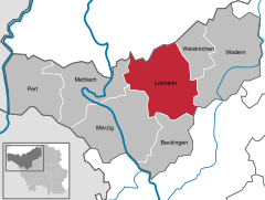
Location of Losheim am See within Merzig-Wadern district 
 | ||
| Coordinates: 49°31′N 6°45′E / 49.517°N 6.750°ECoordinates: 49°31′N 6°45′E / 49.517°N 6.750°E | ||
| Country | Germany | |
| State | Saarland | |
| District | Merzig-Wadern | |
| Government | ||
| • Mayor | Lothar Christ (SPD) | |
| Area | ||
| • Total | 96.79 km2 (37.37 sq mi) | |
| Elevation | 330-510 m (−1,340 ft) | |
| Population (2015-12-31)[1] | ||
| • Total | 15,995 | |
| • Density | 170/km2 (430/sq mi) | |
| Time zone | CET/CEST (UTC+1/+2) | |
| Postal codes | 66679 | |
| Dialling codes | 06872 | |
| Vehicle registration | MZG | |
| Website | www.losheim-stausee.de | |
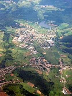
Losheim am See is a municipality in the district Merzig-Wadern, in Saarland, Germany. It is situated on the southern ridge of the Hunsrück, approximately 10 kilometers northeast of Merzig, and 35 kilometers northwest of Saarbrücken. In 1974 a reservoir was created in the north of Losheim that has become a popular spot for recreational activities such as hiking and swimming.
Losheim am See is twinned with the following municipalities:[2]
- Capannori, Italy
- Lacroix-Saint-Ouen, France
- Copargo, Benin
- Bokungu, Democratic Republic of the Congo
- Mount Gilead, North Carolina, United States
Municipal organization
The municipality is composed of 12 villages: Bachem, Bergen, Britten, Hausbach, Losheim, Mitlosheim, Niederlosheim, Rimlingen, Rissenthal, Scheiden, Wahlen and Waldhölzbach.
References
- ↑ "Fläche und Bevölkerung - Stand: 31.12.2015 (Basis Zensus 2011)" (PDF). Statistisches Amt des Saarlandes (in German). July 2016.
- ↑ Losheim am See official website
This article is issued from
Wikipedia.
The text is licensed under Creative Commons - Attribution - Sharealike.
Additional terms may apply for the media files.
