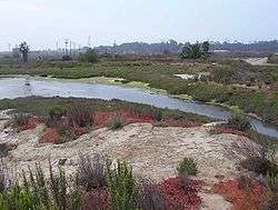
Los Cerritos Wetlands

Los Cerritos Wetlands is located on the border of Los Angeles County and Orange County, spanning the cities of Long Beach, California, and Seal Beach, California, not far from the mouth of the San Gabriel River near the Pacific Ocean. Once a vast marsh covering approximately 2,400 acres (971 ha), it is now classified as a “degraded wetlands”. A coalition of public and private entities are working to protect, purchase, and restore the remaining 776 acres (314 ha).
Environment and wildlife

Los Cerritos Wetlands consists of two functioning marshes (Steamshovel Slough and Zedler Marsh), plus a number of seasonal brackish ponds,[1] all with an abundance of wildlife. The wetlands is home to several endangered species, including the Belding's Savannah sparrow, California least tern, California brown pelican, wandering skipper, and the tiger beetle.[2] A number of species protected under other acts also inhabit the wetlands, in addition to the many common plants and animals typical of a California coastal salt marsh habitat.
Most of the remaining open space, once a thriving wetlands consisting of tidal salt marshes, lagoons, bays and alkali meadows where the San Gabriel River flows into the Pacific Ocean,[3] is currently privately owned and used for oil operations.
Restoration project
The cities of Long Beach and Seal Beach, the California Coastal Conservancy, the Rivers and Mountains Conservancy [4] several local businesses, grassroots and community groups,[5] and individual citizens[6] are working to protect, purchase and restore the remaining acreage of the Los Cerritos Wetlands.
172 acres (0.70 km2) of land has been acquired by the Los Cerritos Wetlands Authority; a total of 255.67 acres (1.0347 km2) within the wetland boundaries are now public lands.[7] The official community-based restoration “kick off” began September 19, 2009, with the Los Cerritos Wetlands Stewardship Program’s Zedler Marsh Cleanup Day event. Regular habitat restoration days have since been held.[8] A conceptual restoration plan for the entire Los Cerritos Wetlands complex is underway.[9]
References
- ↑ "Los Cerritos Wetlands, Gum Grove Park and Heron Pointe Education Center", Enjoy California's Open Spaces.
- ↑ "Los Cerritos Wetlands", Los Cerritos Wetlands Stewards website.
- ↑ "Historical Ecology and Landscape Change of the San Gabriel River and Floodplain" San Gabriel and Lower Los Angeles Rivers and Mountains Conservancy
- ↑ "About Us", Los Cerritos Wetlands
- ↑ "Our Partners", Los Cerritos Wetlands Authority
- ↑ "Save Los Cerritos Wetlands", Save Los Cerritos Wetlands community group
- ↑ "The Wetlands", Los Cerritos Wetlands Authority.
- ↑ "Public Events", Los Cerritos Wetlands Authority.
- ↑ "Conceptual Restoration Plan", Into Los Cerritos Wetlands
External links
Coordinates: 33°45′43″N 118°6′30″W / 33.76194°N 118.10833°W