| Listing name |
Image |
Location |
Coordinates |
Description |
|---|
| Adelgade 77 | | Adelgade 77, 4720 Præstø | 55°7′20.88″N 12°2′35.91″E / 55.1224667°N 12.0433083°E / 55.1224667; 12.0433083 | Townhouse from the middle of the 18th century which was extended with six bays in c. 1800 and expanded with an extra floor in 1842 and rebuilt in brick in the 1899s[1] |
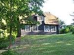
| Beldringe | | Hastrupvej 1, 4720 Præstø | 55°6′21.77″N 11°59′31.51″E / 55.1060472°N 11.9920861°E / 55.1060472; 11.9920861 | Main building from 1561[2] |
| | Hastrupvej 1, 4720 Præstø | 55°6′21.77″N 11°59′31.51″E / 55.1060472°N 11.9920861°E / 55.1060472; 11.9920861 | Half-timbered barn from 1716[3] |
| Borgmestergården | _01.jpg) | Grønnegade 1, 4720 Præstø | 55°7′23.32″N 12°2′30.68″E / 55.1231444°N 12.0418556°E / 55.1231444; 12.0418556 | Former residence of the local mayor from 1723 with later changes and side and rear wings from 1826 [4] |
| Christinelund | | Christinelundsvej 36, 4720 Præstø | 55°7′29.57″N 12°4′29.57″E / 55.1248806°N 12.0748806°E / 55.1248806; 12.0748806 | Main building from 1859-60 designed by Ferdinand Meldahl[5] |
| | Christinelundsvej 38, 4720 Præstø | 55°7′8.56″N 12°4′29.57″E / 55.1190444°N 12.0748806°E / 55.1190444; 12.0748806 | [6] |
| Den Borgerlige Velgørenheds Stiftelse |  | Jomfrustræde 8, 4720 Præstø | 55°7′25.97″N 12°2′45.64″E / 55.1238806°N 12.0460111°E / 55.1238806; 12.0460111 | Building fronting the street from 1869 and wall on Klosternakken[7] |
 | Jomfrustræde 8, 4720 Præstø | 55°7′25.97″N 12°2′45.64″E / 55.1238806°N 12.0460111°E / 55.1238806; 12.0460111 | Side wing from 1870 and wall on Klosternakken[8] |
| Det gamle Sprøjtehus | | Slotstorvet 5, 4760 Vordingborg | 55°0′27.67″N 11°54′36.84″E / 55.0076861°N 11.9102333°E / 55.0076861; 11.9102333 | Fire station from 1854[9] |
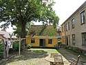
| Gammel Øbjerggård | | Bygaden 27, 4750 Lundby | 55°6′35.14″N 11°49′32.42″E / 55.1097611°N 11.8256722°E / 55.1097611; 11.8256722 | Main building from c. 1780[10] |
| Grundtvig House | .jpg) | Torvestræde 7A, 4720 Præstø | 1821 | Long, one-storey house with a three-bay wall dormer above the gate | Ref |
 | Torvestræde 7F, 4720 Præstø | 1821 | Rear wing from 1821 | Ref |
 | Torvestræde 7, 4720 Præstø | 1826 | Side wing from 1826 | Ref |
| Grønnegade 9 |  | Grønnegade 9, 4720 Præstø | 1859 | Townhouse from 1859 | Ref |
| Grønnegade 11 |  | Grønnegade 11, 4720 Præstø | 1859 | Townhouse from 1859, the eastern side wing from 1859 and the western side wing from 1871 | Ref |
| Grønnegade 12 | .jpg) | Grønnegade 12, 4720 Præstø | 1855 | A former wood workshop from 1855 converted into a townhouse in 1874 | Ref |
| Gåsetårnet | 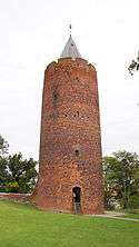 | Slotstorvet 9, 4760 Vordingborg | 55°00′25.27″N 11°54′39.23″E / 55.0070194°N 11.9108972°E / 55.0070194; 11.9108972 | [11] |
| H.C. Olsens Pakhus |  | Havnepladsen 8, 4720 Præstø | 55°7′26.87″N 12°2′31.39″E / 55.1241306°N 12.0420528°E / 55.1241306; 12.0420528 | Warehouse from 1898[12] |
| Havnestræde 2, 4 B-C | 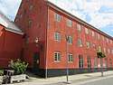 | Havnestræde 2, 4720 Præstø | 55°7′17.05″N 12°2′21.24″E / 55.1214028°N 12.0392333°E / 55.1214028; 12.0392333 | Side wing along Havnestræde from 1856[13] |
| Havnepladsen 12 |  | Havnepladsen 12, 4720 Præstø | 55°7′28.11″N 12°2′34.47″E / 55.1244750°N 12.0429083°E / 55.1244750; 12.0429083 | Warehouse from 1842[14] |
| Køng Hospital | | Bygaden 16, 4750 Lundby | 55°6′35.29″N 11°49′38.59″E / 55.1098028°N 11.8273861°E / 55.1098028; 11.8273861 | Hospital building from 1793[15] |
| Klosternakken 1 |  | Klosternakken 1, 4720 Præstø | 55°7′26.88″N 12°2′44.72″E / 55.1241333°N 12.0457556°E / 55.1241333; 12.0457556 | Townhouse with side wing from 1857[16] |
| Klosternakken 3 |  | Klosternakken 3, 4720 Præstø | 55°7′27.05″N 12°2′45.5″E / 55.1241806°N 12.045972°E / 55.1241806; 12.045972 | Townhouse from 1857 by M. S. Miede[17] |
| Klosternakken 5 |  | Klosternakken 3, 4720 Præstø | 55°7′27.16″N 12°2′46.09″E / 55.1242111°N 12.0461361°E / 55.1242111; 12.0461361 | Townhouse from 1857 by M. S. Miede[18] |
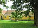
| Lundbygård | | Lundbygårdsvej 100, 4750 Lundby | 55°7′33.48″N 11°53′45.79″E / 55.1259667°N 11.8960528°E / 55.1259667; 11.8960528 | Three-winged main building from 1806[19] |
| Magleby Rectory | | Klintevej 502, 4791 Borre | 54°59′2.26″N 12°29′5.57″E / 54.9839611°N 12.4848806°E / 54.9839611; 12.4848806 | Residential wing from 1849[20] |
| | Klintevej 502, 4791 Borre | 54°59′2.26″N 12°29′5.57″E / 54.9839611°N 12.4848806°E / 54.9839611; 12.4848806 | Attached outbuilding from 1849[21] |
| | Klintevej 502, 4791 Borre | 54°59′2.26″N 12°29′5.57″E / 54.9839611°N 12.4848806°E / 54.9839611; 12.4848806 | Attached outbuilding from 1849[22] |
| Nybøllegård | | Grønsundvej 50, 4780 Stege | 54°58′17.83″N 12°15′26.74″E / 54.9716194°N 12.2574278°E / 54.9716194; 12.2574278 | Country house from 1856 by Gottlieb Bindesbøll[23] |
| Nysø Manor |  | Nysøvej 3, 4720 Præstø | | Gate wing | Ref |
| | Nysøvej 1, 4720 Præstø | 1673 | Stables (eastern) | Ref |
| | Nysøvej 1, 4720 Præstø | 1673 | Stables (western) | Ref |
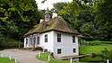
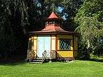
 | Nysøvej 3, 4720 Præstø | 1839 | Pavillon | Ref |
 | Nysøvej 1, 4720 Præstø | 1910 | Barn[24] |
| Officershuset | | Petersværft 4, 4772 Langebæk | 54°58′19.31″N 12°4′41.87″E / 54.9720306°N 12.0782972°E / 54.9720306; 12.0782972 | One-storey, L-shaped brick building with half hipped red tile roof over high celler from 1807 which was expanded in 1885 and again in 1903[25] |
| Ore Lighthouse |  | Petersværft 4, 4772 Langebæk | 55°0′24.7″N 11°52′11.3″E / 55.006861°N 11.869806°E / 55.006861; 11.869806 | [26] |
| Oremandsgårds Husflidsskole | | Kragevigvej 13, 4720 Præstø | 55°4′22.14″N 12°5′51.61″E / 55.0728167°N 12.0976694°E / 55.0728167; 12.0976694 | School building from 1872[27] |
| Oringe Psychiatric Hospital | | Færgegaardsvej 15, 4760 Vordingborg | 55°0′0.37″N 11°54′39.98″E / 55.0001028°N 11.9111056°E / 55.0001028; 11.9111056 | Hospital complex from 1854-57 by Gottlieb Bindesbøll[28] |
| | Færgegaardsvej 15, 4760 Vordingborg | 55°0′0.37″N 11°54′39.98″E / 55.0001028°N 11.9111056°E / 55.0001028; 11.9111056 | Hospital complex from 1854-57 by Gottlieb Bindesbøll[29] |
| | Færgegaardsvej 15, 4760 Vordingborg | 55°0′0.37″N 11°54′39.98″E / 55.0001028°N 11.9111056°E / 55.0001028; 11.9111056 | Hospital complex from 1854-57 by Gottlieb Bindesbøll[30] |
| | Færgegaardsvej 15, 4760 Vordingborg | 55°0′0.37″N 11°54′39.98″E / 55.0001028°N 11.9111056°E / 55.0001028; 11.9111056 | Hospital complex from 1854-57 by Gottlieb Bindesbøll[31] |
| | Færgegaardsvej 15, 4760 Vordingborg | 55°0′0.37″N 11°54′39.98″E / 55.0001028°N 11.9111056°E / 55.0001028; 11.9111056 | Hospital complex from 1854-57 by Gottlieb Bindesbøll[32] |
| | Færgegaardsvej 15, 4760 Vordingborg | 55°0′0.37″N 11°54′39.98″E / 55.0001028°N 11.9111056°E / 55.0001028; 11.9111056 | Hospital complex from 1854-57 by Gottlieb Bindesbøll[33] |
| | Færgegaardsvej 15, 4760 Vordingborg | 55°0′0.37″N 11°54′39.98″E / 55.0001028°N 11.9111056°E / 55.0001028; 11.9111056 | Hospital complex from 1854-57 by Gottlieb Bindesbøll[34] |
| | Færgegaardsvej 15, 4760 Vordingborg | 55°0′0.37″N 11°54′39.98″E / 55.0001028°N 11.9111056°E / 55.0001028; 11.9111056 | Hospital complex from 1854-57 by Gottlieb Bindesbøll[35] |
| | Færgegaardsvej 15, 4760 Vordingborg | 55°0′0.37″N 11°54′39.98″E / 55.0001028°N 11.9111056°E / 55.0001028; 11.9111056 | Hospital complex from 1854-57 by Gottlieb Bindesbøll[36] |
| | Færgegaardsvej 15, 4760 Vordingborg | 55°0′0.37″N 11°54′39.98″E / 55.0001028°N 11.9111056°E / 55.0001028; 11.9111056 | Hospital complex from 1854-57 by Gottlieb Bindesbøll[37] |
| | Færgegaardsvej 15, 4760 Vordingborg | 55°0′0.37″N 11°54′39.98″E / 55.0001028°N 11.9111056°E / 55.0001028; 11.9111056 | Hospital complex from 1854-57 by Gottlieb Bindesbøll[38] |
| Petersgård | | Petersgaard Alle 3, 4772 Langebæk | 55°0′10.88″N 12°6′10.94″E / 55.0030222°N 12.1030389°E / 55.0030222; 12.1030389 | Lighthouse from 1895 by Theodor Wedén[39] |
| Præstø Technical School |  | Jomfrustræde 4, 4720 Præstø | 55°7′24.15″N 12°2′46.57″E / 55.1233750°N 12.0462694°E / 55.1233750; 12.0462694 | School building from 1781 designed by Frederik Wilsbech[40] |
| Rødeled Pottery |  | Rødeledvej 1, 4720 Præstø | 55°7′10.78″N 12°1′32.49″E / 55.1196611°N 12.0256917°E / 55.1196611; 12.0256917 | Pottery from 1897ref>https://www.kulturarv.dk/fbb/sagvis.pub?sag=10745208</ref> |
| | Rødeledvej 1, 4720 Præstø | 55°7′10.78″N 12°1′32.49″E / 55.1196611°N 12.0256917°E / 55.1196611; 12.0256917 | Pottery from 1897[41] |
| | Rødeledvej 1, 4720 Præstø | 55°7′10.78″N 12°1′32.49″E / 55.1196611°N 12.0256917°E / 55.1196611; 12.0256917 | Pottery from 1897[42] |
| | Rødeledvej 1, 4720 Præstø | 55°7′10.78″N 12°1′32.49″E / 55.1196611°N 12.0256917°E / 55.1196611; 12.0256917 | Pottery from 1897[43] |
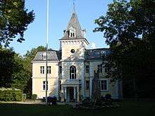
| Rosenfeldt Manor |  | Rosenfeldt 1, 4760 Vordingborg | 55°1′0.59″N 11°52′34.4″E / 55.0168306°N 11.876222°E / 55.0168306; 11.876222 | Main building from 1868-70 by Henrik Steffens Sibbern[44] |
| | Rosenfeldt 1, 4760 Vordingborg | 55°1′0.59″N 11°52′34.4″E / 55.0168306°N 11.876222°E / 55.0168306; 11.876222 | Barn from 1776-77 by Christian Joseph Zuber on the north side of the octagonal courtyard[45] |
| | Rosenfeldt 1, 4760 Vordingborg | 55°1′0.59″N 11°52′34.4″E / 55.0168306°N 11.876222°E / 55.0168306; 11.876222 | Stables from 1776-77 by Christian Joseph Zuber on the north side of the octagonal courtyard[46] |
| | Rosenfeldt 1, 4760 Vordingborg | 55°1′0.59″N 11°52′34.4″E / 55.0168306°N 11.876222°E / 55.0168306; 11.876222 | Farm building from 1776-77 by Christian Joseph Zuber on the northwest side of the octagonal courtyard[47] |
| | Rosenfeldt 1, 4760 Vordingborg | 55°1′0.59″N 11°52′34.4″E / 55.0168306°N 11.876222°E / 55.0168306; 11.876222 | Dairy from 1776-77 by Christian Joseph Zuber on the north side of the octagonal courtyard[48] |
| | Rosenfeldt 2, 4760 Vordingborg | 55°1′1.9″N 11°52′34.4″E / 55.017194°N 11.876222°E / 55.017194; 11.876222 | Residential building from 1776-77 by Christian Joseph Zuber on the south side of the octagonal courtyard[49] |
| | Rosenfeldt 3, 4760 Vordingborg | 55°1′4.48″N 11°52′34.4″E / 55.0179111°N 11.876222°E / 55.0179111; 11.876222 | Residential building from 1776-77 by Christian Joseph Zuber on the northeastern side of the octagonal courtyard[50] |
| Snertinge | | Fæbyvej 121, 4760 Vordingborg | 55°3′50.35″N 11°55′9.83″E / 55.0639861°N 11.9193972°E / 55.0639861; 11.9193972 | Main building from 1857 by erdinand Meldahl[51] |
| | Fæbyvej 121, 4760 Vordingborg | 55°3′50.35″N 11°55′9.83″E / 55.0639861°N 11.9193972°E / 55.0639861; 11.9193972 | [52] |
| | Fæbyvej 123, 4760 Vordingborg | 55°3′51.41″N 11°55′9.83″E / 55.0642806°N 11.9193972°E / 55.0642806; 11.9193972 | [53] |
| Spindeskolen, Køng | | Bygaden 22, 4750 Lundby | 55°6′37.7″N 11°49′32.65″E / 55.110472°N 11.8257361°E / 55.110472; 11.8257361 | School building from 1780[54] |
| Sølyst | | Havnevej 15, 4720 Præstø | 55°7′24.19″N 12°2′26.06″E / 55.1233861°N 12.0405722°E / 55.1233861; 12.0405722 | Building from 1858[55] |
| Torvet 5 | .jpg) | Torvet 5, 4720 Præstø | 55°7′25.01″N 12°2′36.1″E / 55.1236139°N 12.043361°E / 55.1236139; 12.043361 | Building from 1854[56] |
| Torvet 7 | .jpg) | Torvet 7, 4720 Præstø | 55°7′25.18″N 12°2′36.73″E / 55.1236611°N 12.0435361°E / 55.1236611; 12.0435361 | Building from 1819 whose facade and one of the gables were rebuilt in brick in 1846[57] |
| Torvet 9 | _-_image_01.jpg) | Torvet 9, 4720 Præstø | 55°7′25.49″N 12°2′37.75″E / 55.1237472°N 12.0438194°E / 55.1237472; 12.0438194 | Building from before 1738 which was rebuilt in brick in the 19th century and side wing from 1885[58] |
| Præstø Town Hall and Jailhouse |  | Torvet 10, 4720 Præstø | 55°7′24.62″N 12°2′38.32″E / 55.1235056°N 12.0439778°E / 55.1235056; 12.0439778 | Former town hall built in 1823 to a design from c. 1803 by Willads Stilling and Christian Frederuj Hansen which was later expanded and altered in 1868 as well as the jailhouse from 1850[59] |
| Torvet 11 | _-_image_02.jpg) | Torvet 11, 4720 Præstø | 55°7′25.6″N 12°2′38.39″E / 55.123778°N 12.0439972°E / 55.123778; 12.0439972 | Building from 1845[60] |
| Torvet 12 | .jpg) | Torvet 12, 4720 Præstø | 55°7′24.7″N 12°2′39.96″E / 55.123528°N 12.0444333°E / 55.123528; 12.0444333 | Townhouse from 1854 and side wing from 1856 which was heightened in 1867[61] |
| Torvet 20 |  | Torvet 20, 4720 Præstø | 55°7′25.34″N 12°2′42.94″E / 55.1237056°N 12.0452611°E / 55.1237056; 12.0452611 | Townhouse from 1744 which was altered in 1832[62] |
| Torvet 23 | .jpg) | Torvet 23, 4720 Præstø | 55°7′26.71″N 12°2′43.9″E / 55.1240861°N 12.045528°E / 55.1240861; 12.045528 | Townhouse from c. 1853 by M.S. Miede and side wing from c. 1900[63] |
| Torbet 24 | .jpg) | Torvet 24, 4720 Præstø | 55°7′25.55″N 12°2′43.74″E / 55.1237639°N 12.0454833°E / 55.1237639; 12.0454833 | Building from 1913[64] |
|


_03.jpg)
_91.jpg)
.jpg)
.jpg)


.jpg)
.jpg)
_-_baghus.jpg)
.jpg)
.jpg)