List of mountains in Ireland

This is a list of mountains and mountain ranges in Ireland. It also includes landforms that are usually called hills. Those within Northern Ireland or on the border are marked with an asterisk (*), while the rest are within the Republic of Ireland. Mountain ranges are in bold.
Thirteen peaks are classified by the Scottish Mountaineering Club as Furths i.e. mountains over 3,000 feet (910 m) in the British Isles outside Scotland that are regarded as separate mountains.[1] Ten of these are located in Macgillycuddy's Reeks in County Kerry.
Mountains, in both Great Britain and Ireland, are commonly defined as any summit at least 2,000 feet (610 m) high.[2] In addition, some definitions also include a topographical prominence requirement, typically 100 feet (30 m) or 500 feet (150 m).[3]
A number of lists are maintained by the Mountainviews.ie online Hillwalking community, using criteria developed by that community and others. These include; the Valdeleur-Lynams, a list of 269 mountains being of at least 600 m (2,000 ft) in height with a prominence of at least 15 m (50 ft), and the Arderins; a list of 404 mountains of at least 500 m (1,600 ft) in height with a prominence of at least 30 m (100 ft).[4] These lists have been published in book form by Collins Press.[5] Mountainviews.ie classifies a mountain as being above 500 m (1,600 ft), but also maintains a number of lists of hills below this threshold.[6]
Highest peaks
Macgillycuddy's Reeks (Na Cruacha Dubha)
| # | Peak | Other names | Height | Listing |
|---|---|---|---|---|
| 1 | Carrauntoohil | Corrán Tuathail | 1,038 m (3,406 ft)[7] | Furth |
| 2 | Binn Chaorach | Beenkeragh, Benkeeragh | 1,010 m (3,314 ft)[8] | Furth |
| 3 | Cathair na Féinne | Caher | 1,001 m (3,284 ft)[9] | Furth |
| 4 | Cnoc na Péiste | Knocknapeasta | 988 m (3,241 ft)[10] | Furth |
| 5 | Cathair Thiar | Caher West | 975 m (3,199 ft)[11] | Furth |
| 6 | Maolán Buí | — | 973 m (3,192 ft)[12] | Furth |
| 7 | The Bones | Carrauntoohil Tooth, Knockoughter | 959 m (3,146 ft)[13] | Furth |
| 8 | Cnoc an Chuillinn | — | 958 m (3,143 ft)[14] | Furth |
| 9 | An Gunna Mór | The Big Gun | 939 m (3,081 ft)[15] | Furth |
| 10 | Cruach Mhór | — | 932 m (3,058 ft)[16] | Furth |
Elsewhere in Ireland
| # | Peak | Height | Location | Listing |
|---|---|---|---|---|
| 1 | Mount Brandon (Cnoc Bréanainn) | 951 m (3,120 ft) | Dingle Peninsula Mountains, County Kerry | Furth |
| 2 | Lugnaquilla (Log na Coille) | 925 m (3,035 ft) | Wicklow Mountains, County Wicklow | Furth |
| 3 | Galtymore (Cnoc Mór na nGaibhlte) | 917 m (3,009 ft) | Galty Mountains, County Tipperary County Limerick | Furth |
| 4 | Slieve Donard (Sliabh Dónairt)* | 852 m (2,795 ft) | Mourne Mountains, County Down | |
| 5 | Baurtregaum (Barr Trí gCom) | 851 m (2,792 ft) | Slieve Mish Mountains, County Kerry | |
| 6 | Mullaghcleevaun (Mullach Cliabháin) | 849 m (2,785 ft) | Wicklow Mountains, County Wicklow | |
| 7 | Mangerton (An Mhangarta) | 839 m (2,753 ft) | Mangerton Mountains, County Kerry | |
| 8 | Caherconree (Cathair Conraoi) | 835 m (2,740 ft) | Slieve Mish Mountains, County Kerry | |
| 9 | Purple Mountain (Sliabh Corcra) | 832 m (2,730 ft) | Purple Mountains, County Kerry | |
| 10 | Beenoskee (Binn os Gaoith) | 826 m (2,710 ft) | Dingle Peninsula Mountains, County Kerry |
List by province
| Provinces of Ireland Cúigí na hÉireann | |
 | |
| Leinster Munster Connacht Ulster |
Munster
- An Triúr Deirfiúr – County Kerry
- Ballyhoura Mountains – Counties Cork and Limerick
- Boggeragh Mountains – County Cork
- Caha Mountains – County Cork
- Comeragh Mountains – County Waterford
- Derrynasaggart Mountains – County Cork
- Devil's Bit – County Tipperary
- Dingle Peninsula – County Kerry
- Mount Brandon (952 m, 3,123 ft)
- Beenoskee
- Mount Eagle
- Galty Mountains – Counties Cork, Limerick, Tipperary
- Galtymore (917 m, 3,009 ft)
- Temple Hill
- Geokaun Mountain – County Kerry
- Glanaruddery Mountains – County Kerry
- Ivereagh Peninsula – County Kerry
- Knockmealdown Mountains – Counties Tipperary and Waterford
- Macgillycuddy's Reeks – County Kerry
- Carrauntoohil (1,038 m, 3,406 ft)
- Knocknapeasta (988 m, 3,241 ft)
- Mountains of East Kerry also known as Mangerton Mountains – County Kerry
- Mangerton Mountain (843 m, 2,766 ft)
- Torc Mountain
- Mount Gabriel – County Cork
- Mullaghareirk Mountains – Counties Cork and Limerick
- Purple Mountain – County Kerry
- Shehy Mountains – Counties Cork and Kerry
- Silvermine Mountains – Counties Tipperary and Limerick
- Paps of Anu (670 m, 2,198 ft) – County Kerry
- Slieve Aughty – County Clare
- Slieve Callan – County Clare
- Slieve Mish Mountains – County Kerry
- Baurtregaum (851 m, 2,792 ft)
- Caherconree (835 m, 2,740 ft)
- Slieve Miskish Mountains – County Cork
- Slieveardagh Hills (340 m, 1,115 ft) – Counties Tipperary and Kilkenny
- Slievenamon (719 m, 2,359 ft) – County Tipperary
- Stack's Mountains – County Kerry
Leinster
- Blackstairs Mountains – Counties Carlow and Wexford
- Black Rock Mountain (536 m, 1,759 ft)
- Blackstairs Mountain (735 m, 2,411 ft)
- Croaghaun (455 m, 1,493 ft)
- Mount Leinster (795 m, 2,608 ft)
- Brandon Hill (515 m, 1,690 ft) – County Kilkenny
- Carn Clonhugh also known as Corn Hill – County Longford
- Cooley Mountains – County Louth
- Clermont Carn
- Slieve Foy (588 m, 1,929 ft)
- Coppanagh – County Kilkenny
- Croghan Hill (234 m, 768 ft) – County Offaly
- Dalkey Hill (140 m, 459 ft) – County Dun Laoghaire-Rathdown (old County Dublin)
- Faughan Hill – County Meath
- Hill of Allen (206 m, 676 ft) – County Kildare
- Hill of Ben – County Westmeath
- Hill of Tara – County Meath
- Hill of Uisneach (182 m, 597 ft) – County Westmeath
- Hill of Ward – County Meath
- Killiney Hill (153 m, 502 ft) – County Dun Laoghaire-Rathdown (old County Dublin)
- Knockeyon – County Westmeath
- Mount Alto – County Kilkenny
- Mullaghmeen – County Westmeath
- Naul Hills (122 m, 400 ft)
- Slieveardagh Hills – County Kilkenny
- Shielmartin Hill (163 m, 535 ft) – County Fingal (old County Dublin)
- Slieve Bloom Mountains – Counties Laois and Offaly
- Arderin (527 m, 1,729 ft)
- Barcam
- Baunreaghcong (509 m, 1,670 ft)
- Carroll's Hill
- Castleconor
- Farbreague
- Garraunbaun
- Ridge of Capard
- Stillbrook Hill (514 m, 1,686 ft)
- Wolftrap Mountain
- Slieveboy (420 m, 1,378 ft) – County Wexford
- Slieve na Calliagh – County Meath
- Wicklow Mountains
- Annagh Hill
- Camaderry (699 m, 2,293 ft)
- Camenabologue
- Carrick Mountain
- Church Mountain also known as Slieve Gad (543 m, 1,781 ft)
- Cloghernagh (800 m, 2,625 ft)
- Conavalla
- Corrigasleggaun
- Croghan Mountain
- Cupidstown Hill (379 m, 1,243 ft)
- Djouce (725 m, 2,379 ft)
- Duff Hill (720 m, 2,362 ft)
- Gravale (718 m, 2,356 ft)
- Great Sugar Loaf (501 m, 1,644 ft)
- Keadeen
- Kilmashogue
- Kippure (757 m, 2,484 ft)
- Larch Hill
- Little Sugar Loaf also known as Giltspur Mountain (300 m, 984 ft)
- Lobawn
- Luggala also known as Fancy Mountain
- Lugnaquilla (924 m, 3,031 ft)
- Maulin
- Montpelier Hill (383 m, 1,257 ft)
- Mullacor
- Mullaghcleevaun (849 m, 2,785 ft)
- Seefingan
- Slievemaan (759 m, 2,490 ft)
- Sugarloaf (West Wicklow)
- Table Mountain
- Tibradden Mountain (467 m, 1,532 ft)
- Tonelagee (817 m, 2,680 ft)
- Two Rock (536 m, 1,759 ft) and Three Rock (450 m, 1,476 ft)
Ulster
- Antrim Hills* – County Antrim
- Antrim Plateau* – County Londonderry
- Belfast Hills* – County Antrim
- Lisburn* – County Antrim
- Belmore Mountain* – County Fermanagh
- Bluestack Mountains also known as Croaghgorms – County Donegal
- Cuilcagh* and Benaughlin* – Counties Fermanagh and Cavan
- Derryveagh Mountains – County Donegal
- Inishowen
- Loughermore* – County Londonderry
- Mourne Mountains* – County Down
- Slieve Bearnagh
- Slieve Binnian
- Slieve Commedagh
- Slieve Donard (850 m, 2,789 ft)
- Slieve Muck
- Ben Crom
- Ouley Hill* – County Down
- Slieve Beagh* – Counties Fermanagh, Tyrone, Monaghan
- Slieve Croob* – County Down
- Slieve Gullion* – County Armagh
- Sliabh gCuircin* Camlough Mountain (423 m, 1,388 ft) – County Armagh
- Slieve Rushen* – Counties Fermanagh and Cavan
- Southwest Donegal – County Donegal
- Sperrins* – Counties Londonderry and Tyrone
Connacht
- Achill Island – County Mayo
- Croaghaun
- Slievemore (671 m, 2,201 ft)
- Ben Gorm – County Mayo
- Croagh Patrick (764 m, 2,507 ft) – County Mayo
- Clare Island – County Mayo
- Knockmore (462 m, 1,516 ft)
- Curlew Mountains – Counties Sligo and Roscommon
- Dartry Mountains – Counties Sligo and Leitrim
- Knocknarea – County Sligo
- Maumturks – County Galway
- Mweelrea (814 m, 2,671 ft) – County Mayo
- Nephin Beg Range – County Mayo
- Nephin (806 m, 2,644 ft)
- Nephin Beg (627 m, 2,057 ft)
- Slieve Carr (721 m, 2,365 ft)
- Ox Mountains – County Sligo
- Partry Mountains – Counties Mayo and Galway
- Devilsmother (645 m, 2,116 ft)
- Maumtrasna – County Mayo
- Sheeffry Range – County Mayo
- Twelve Bens – County Galway
- Errisbeg
- Diamond Hill
- Tully Mountain
See also
- Northern Ireland: List of Hewitts and List of Marilyns
- Republic of Ireland: List of Hewitts and List of Marilyns
- Geography of Ireland
- List of Irish counties by highest point
- List of mountains and hills of County Mayo
References
- ↑ Mountains – Key Facts. The Munros, Corbetts, Grahams, Donalds & Furths at www.smc.org.uk. Accessed on 9 Feb 2013.
- ↑ Wilson, Peter (2001). Listing the Irish hills and mountains in Irish Geography, Vol 34(1), University of Ulster, Coleraine, p. 89. (pdf)
- ↑ A Mountain is a Mountain – isn't it? at www.go4awalk.com. Accessed on 3 Feb 2013.
- ↑ http://www.Mountainviews.ie
- ↑ Mountainviews, (2013), "A Guide to Ireland's Mountain Summits: The Vandeleur-Lynams & the Arderins", Collins Books, Cork, ISBN 978-1-84889-164-7
- ↑ http://www.Mountainviews,ie
- ↑ MountainViews – Corrán Tuathail/Carrauntoohil
- ↑ MountainViews – Binn Chaorach/Beenkeragh
- ↑ MountainViews – Cathair na Féinne/Caher
- ↑ MountainViews Cnoc na Péiste/Knocknapeasta
- ↑ MountainViews Cathair Thiar/Caher West
- ↑ MountainViews – Maolán Buí
- ↑ MountainViews – The Bones
- ↑ MountainViews – Cnoc an Chuillinn
- ↑ MountainViews An Gunna Mhór/The Big Gun
- ↑ MountainViews – Cruach Mhór
External links
| Wikimedia Commons has media related to Mountains of Ireland. |
- Vandeleur-Lynam list of peaks over 600m
- Arderins List of peaks over 500m.
- Ordnance Survey Ireland – Online map viewer
- Placenames Database of Ireland
Mountains and hills of Connacht | ||
|---|---|---|
| Achill Island |  | |
| Dartry Mountains | ||
| Maumturks | ||
| Nephin Range | ||
| Ox Mountains | ||
| Partry Mountains | ||
| Sheeffry Range | ||
| Twelve Bens | ||
| Others | ||


Mountains and hills of Ulster | ||
|---|---|---|
| Antrim Hills |  | |
| Antrim Plateau | ||
| Belfast Hills | ||
| Croaghgorms | ||
| Derryveagh | ||
| Inishowen | ||
| Mournes | ||
| Sperrins | ||
| Southwest Donegal | ||
| Others | ||
Mountains and hills of Great Britain and Ireland | ||
|---|---|---|
| Scotland | 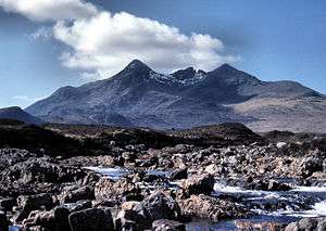 | |
| England |
| |
| Wales |
| |
| Northern Ireland | ||
| Republic of Ireland | ||