List of Sites of Special Scientific Interest in Leicestershire

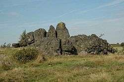
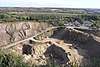
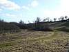
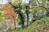
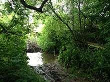
The "Bomb Rocks", Charnwood Lodge SSSI

The following is a list of Sites of Special Scientific Interest (SSSIs) in Leicestershire. As of August 2017, there are 76 SSSIs in the county,[1] 57 of which are designated for their biology, 12 for their geology and 7 for both criteria.

SSSIs in Rutland are listed separately.


Key

Sites

Site name Photograph B G Area[lower-alpha 1] Public
access
Location[lower-alpha 1] Other
classifications
Map[lower-alpha 2] Citation[lower-alpha 3] Description
Allexton Wood Allexton Wood Green tick 25.8 hectares
(64 acres)
[2]
NO Uppingham
52°35′10″N 0°47′17″W / 52.586°N 0.788°W / 52.586; -0.788 (Allexton Wood)
SP822994
[2]
Map Citation This coppice semi-natural wood is on soils derived from glacial and Jurassic clays. The dominant tree is ash, and elm and pedunculate oak are also common. There are several small streams with populations of opposite-leaved golden saxifrage.[3]
Ashby Canal Ashby Canal Green tick 15.4 hectares
(38 acres)
Leicester
52°39′43″N 1°27′47″W / 52.662°N 1.463°W / 52.662; -1.463 (Ashby Canal)
SK364073
Map Citation
Bardon Hill Bardon Hill Green tick 13 hectares
(32 acres)
Coalville
52°42′43″N 1°19′12″W / 52.712°N 1.32°W / 52.712; -1.32 (Bardon Hill)
SK460130
Map Citation
Bardon Hill Quarry Bardon Hill Quarry Green tick 58.1 hectares
(144 acres)
Coalville
52°42′40″N 1°19′44″W / 52.711°N 1.329°W / 52.711; -1.329 (Bardon Hill Quarry)
SK454129
GCR[4][5] Map Citation
Barrow Gravel Pits Green tick 35.7 hectares
(88 acres)
Loughborough
52°44′38″N 1°09′29″W / 52.744°N 1.158°W / 52.744; -1.158 (Barrow Gravel Pits)
SK569166
Map Citation
Beacon Hill, Hangingstone and Outwoods Beacon Hill Green tick Green tick 147.4 hectares
(364 acres)
Loughborough
52°44′28″N 1°14′24″W / 52.741°N 1.24°W / 52.741; -1.24 (Beacon Hill, Hangingstone and Out Woods)
SK514163
GCR[6] Map Citation
Benscliffe Wood Benscliffe Wood Green tick 9.8 hectares
(24 acres)
Leicester
52°42′32″N 1°14′31″W / 52.709°N 1.242°W / 52.709; -1.242 (Benscliffe Wood)
SK513127
Map Citation
Blackbrook Reservoir Blackbrook Reservoir Green tick 39.3 hectares
(97 acres)
Shepshed
52°45′04″N 1°19′19″W / 52.751°N 1.322°W / 52.751; -1.322 (Blackbrook Reservoir)
SK458173
Map Citation
Botcheston Bog Green tick 2.8 hectares
(6.9 acres)
Leicester
52°38′13″N 1°17′02″W / 52.637°N 1.284°W / 52.637; -1.284 (Botcheston Bog)
SK485047
Map Citation
Bradgate Park and Cropston Reservoir Cropston Reservoir Green tick Green tick 399.3 hectares
(987 acres)
Leicester
52°41′20″N 1°13′01″W / 52.689°N 1.217°W / 52.689; -1.217 (Bradgate Park and Cropston Reservoir)
SK530105
GCR,[7][8] SM[9] Map Citation
Breedon Cloud Wood and Quarry Breedon Quarry Green tick Green tick 63.2 hectares
(156 acres)
Loughborough
52°47′10″N 1°23′13″W / 52.786°N 1.387°W / 52.786; -1.387 (Breedon Cloud Wood and Quarry)
SK414212
GCR,[10] LRWT[11] Map Citation
Breedon Hill Breedon Hill Green tick 5.2 hectares
(13 acres)
Loughborough
52°48′14″N 1°24′07″W / 52.804°N 1.402°W / 52.804; -1.402 (Breedon Hill)
SK404232
Map Citation
Briery Wood Heronry, Belvoir Green tick 5.6 hectares
(14 acres)
Grantham
52°53′13″N 0°46′30″W / 52.887°N 0.775°W / 52.887; -0.775 (Briery Wood Heronry, Belvoir)
SK825329
Map Citation
Buddon Wood and Swithland Reservoir Swithland Reservoir Green tick Green tick 187.1 hectares
(462 acres)
Leicester
52°43′37″N 1°10′12″W / 52.727°N 1.17°W / 52.727; -1.17 (Buddon Wood and Swithland Reservoir)
SK561147
GCR[12] Map Citation
Burbage Wood and Aston Firs Burbage Wood and Aston Firs Green tick 51.1 hectares
(126 acres)
Hinckley
52°32′28″N 1°20′02″W / 52.541°N 1.334°W / 52.541; -1.334 (Burbage Wood and Aston Firs)
SP452940
LNR[13] Map Citation
Cave's Inn Pits Green tick 5.8 hectares
(14 acres)
Lutterworth
52°25′N 1°13′W / 52.41°N 1.21°W / 52.41; -1.21 (Cave's Inn Pits)
SP538795
Map Citation
Charnwood Lodge Charnwood Lodge Green tick Green tick 134.2 hectares
(332 acres)
Coalville
52°43′59″N 1°18′43″W / 52.733°N 1.312°W / 52.733; -1.312 (Charnwood Lodge)
SK465153
GCR,[14][15] LRWT,[16] NNR[17] Map Citation
Chater Valley Green tick 3.8 hectares
(9.4 acres)
Uppingham
52°37′55″N 0°48′58″W / 52.632°N 0.816°W / 52.632; -0.816 (Chater Valley)
SK802045
Map Citation
Cliffe Hill Quarry Green tick 19.2 hectares
(47 acres)
Coalville
52°41′28″N 1°18′00″W / 52.691°N 1.3°W / 52.691; -1.3 (Cliffe Hill Quarry)
SK474107
GCR[18] Map Citation
Coalville Meadows Green tick 6 hectares
(15 acres)
Coalville
52°44′N 1°20′W / 52.73°N 1.34°W / 52.73; -1.34 (Coalville Meadows)
SK446150
Map Citation
Cotes Grassland Green tick 3.2 hectares
(7.9 acres)
Loughborough
52°46′52″N 1°10′52″W / 52.781°N 1.181°W / 52.781; -1.181 (Cotes Grassland)
SK553208
Map Citation
Cribb's Lodge Meadows Green tick 4.1 hectares
(10 acres)
Melton Mowbray
52°45′32″N 0°40′08″W / 52.759°N 0.669°W / 52.759; -0.669 (Cribb's Lodge Meadows)
SK899188
LRWT,[19] NCR,[20] NNR[17] Map Citation
Croft and Huncote Quarry Croft Quarry Green tick 35.2 hectares
(87 acres)
Hinckley
52°33′47″N 1°14′49″W / 52.563°N 1.247°W / 52.563; -1.247 (Croft and Huncote Quarry)
SP511965
GCR[21] Map Citation
Croft Hill Croft Hill Green tick 2 hectares
(4.9 acres)
Hinckley
52°33′50″N 1°15′00″W / 52.564°N 1.25°W / 52.564; -1.25 (Croft Hill)
SP509966
Map Citation
Croft Pasture Croft Pasture Green tick 6.1 hectares
(15 acres)
Hinckley
52°33′25″N 1°15′00″W / 52.557°N 1.25°W / 52.557; -1.25 (Croft Pasture)
SP509958
LRWT[22] Map Citation
Croxton Park Croxton Park Green tick 97.3 hectares
(240 acres)
Melton Mowbray
52°50′24″N 0°47′06″W / 52.84°N 0.785°W / 52.84; -0.785 (Croxton Park)
SK819277
Map Citation
Debdale Meadow, Muston Debdale Meadow Green tick 4.3 hectares
(11 acres)
Grantham
52°56′38″N 0°45′36″W / 52.944°N 0.76°W / 52.944; -0.76 (Debdale Meadow, Muston)
SK834393
Map Citation
Dimminsdale Dimminsdale Green tick Green tick 36.9 hectares
(91 acres)
Coalville
52°47′24″N 1°26′35″W / 52.79°N 1.443°W / 52.79; -1.443 (Dimminsdale)
SK376216
LRWT[23] Map[lower-alpha 4] Citation
Donington Park Donington Park Green tick 38.9 hectares
(96 acres)
Loughborough
52°50′13″N 1°23′10″W / 52.837°N 1.386°W / 52.837; -1.386 (Donington Park)
SK414268
Map Citation
Enderby Warren Quarry Green tick 1.6 hectares
(4.0 acres)
Leicester
52°35′42″N 1°12′14″W / 52.595°N 1.204°W / 52.595; -1.204 (Enderby Warren Quarry)
SK540000
GCR[24] Map Citation
Eye Brook Reservoir Eye Brook Reservoi Green tick 201.3 hectares
(497 acres)
Uppingham
52°32′53″N 0°44′46″W / 52.548°N 0.746°W / 52.548; -0.746 (Eye Brook Reservoir)
SP851953
Map[lower-alpha 5] Citation
Eye Brook Valley Woods Green tick 65.7 hectares
(162 acres)
Uppingham
52°33′47″N 0°46′55″W / 52.563°N 0.782°W / 52.563; -0.782 (Eye Brook Valley Woods)
SP826969
LRWT[25] Map Citation
Frisby Marsh Frisby Marsh Green tick 10.1 hectares
(25 acres)
Loughborough
52°44′56″N 0°59′06″W / 52.749°N 0.985°W / 52.749; -0.985 (Frisby Marsh)
SK686174
Map Citation
Gipsy Lane Pit Green tick 0.5 hectares
(1.2 acres)
Leicester
52°39′29″N 1°05′10″W / 52.658°N 1.086°W / 52.658; -1.086 (Gipsy Lane Pit)
SK619071
GCR[26] Map Citation
Grace Dieu and High Sharpley Grace Dieu and High Sharpley Green tick Green tick 86 hectares
(210 acres)
Coalville
52°44′53″N 1°21′07″W / 52.748°N 1.352°W / 52.748; -1.352 (Grace Dieu and High Sharpley)
SK438170
GCR[27] Map Citation
Grantham Canal Grantham Canal Green tick 9.4 hectares
(23 acres)
Grantham
52°53′42″N 0°52′01″W / 52.895°N 0.867°W / 52.895; -0.867 (Grantham Canal)
SK763337
Map Citation
Great Bowden Borrowpit Green tick 2.4 hectares
(5.9 acres)
Market Harborough
52°30′04″N 0°54′22″W / 52.501°N 0.906°W / 52.501; -0.906 (Great Bowden Borrowpit)
SP743898
Map Citation
Groby Pool and Woods Groby Pool Green tick 29 hectares
(72 acres)
Leicester
52°40′08″N 1°13′59″W / 52.669°N 1.233°W / 52.669; -1.233 (Groby Pool and Woods)
SK519082
Map Citation
Harby Hill Wood Green tick 17.2 hectares
(43 acres)
Melton Mowbray
52°50′53″N 0°52′08″W / 52.848°N 0.869°W / 52.848; -0.869 (Harby Hill Wood)
SK762285
Map Citation
Holly Rock Fields Green tick 3.9 hectares
(9.6 acres)
Coalville
52°43′30″N 1°19′08″W / 52.725°N 1.319°W / 52.725; -1.319 (Holly Rock Fields)
SK461144
Map Citation
Holwell Mouth Holwell Mouth Green tick 15.7 hectares
(39 acres)
Melton Mowbray
52°48′47″N 0°55′37″W / 52.813°N 0.927°W / 52.813; -0.927 (Holwell Mouth)
SK724245
Map Citation
Ives Head Green tick 4.0 hectares
(9.9 acres)
Coalville
52°44′56″N 1°17′35″W / 52.749°N 1.293°W / 52.749; -1.293 (Ives Head)
SK478170
GCR[28] Map Citation
Kendall's Meadow Green tick 2.6 hectares
(6.4 acres)
Hinckley
52°34′41″N 1°25′16″W / 52.578°N 1.421°W / 52.578; -1.421 (Kendall's Meadow)
SP393980
Map Citation
Kilby - Foxton Canal Kilby - Foxton Canal Green tick 32 hectares
(79 acres)
Leicester
52°33′25″N 1°02′20″W / 52.557°N 1.039°W / 52.557; -1.039 (Kilby - Foxton Cana)
SP652959
Map Citation
King Lud's Entrenchments and The Drift The Drift Green tick 23.9 hectares
(59 acres)
Melton Mowbray
52°50′31″N 0°43′16″W / 52.842°N 0.721°W / 52.842; -0.721 (King Lud's Entrenchments and The Drift)
SK862280
SM[29] Map[lower-alpha 6] Citation
Launde Big Wood Launde Big Wood Green tick 41.1 hectares
(102 acres)
Uppingham
52°37′30″N 0°50′24″W / 52.625°N 0.84°W / 52.625; -0.84 (Launde Big Wood)
SK786037
LRWT[30] Map Citation
Leighfield Forest Leighfield Forest Green tick 149.7 hectares
(370 acres)
Leicester
52°36′40″N 0°51′29″W / 52.611°N 0.858°W / 52.611; -0.858 (Leighfield Forest)
SK774021
NCR[31] Map Citation
Lockington Marshes Green tick 11.3 hectares
(28 acres)
Loughborough
52°51′47″N 1°16′41″W / 52.863°N 1.278°W / 52.863; -1.278 (Lockington Marshes)
SK487298
Map Citation
Loughborough Meadows Loughborough Meadows Green tick 60.5 hectares
(149 acres)
Loughborough
52°47′28″N 1°12′22″W / 52.791°N 1.206°W / 52.791; -1.206 (Loughborough Meadows)
SK536218
LRWT[32] Map Citation
Lount Meadows Green tick 8.5 hectares
(21 acres)
Coalville
52°46′05″N 1°25′44″W / 52.768°N 1.429°W / 52.768; -1.429 (Lount Meadows)
SK386191
Map Citation
Main Quarry, Mountsorrel Green tick 14.6 hectares
(36 acres)
Leicester
52°43′37″N 1°08′49″W / 52.727°N 1.147°W / 52.727; -1.147 (Main Quarry, Mountsorrel)
SK577148
GCR[33] Map Citation
Misterton Marshes Green tick 6.8 hectares
(17 acres)
Lutterworth
52°27′40″N 1°10′52″W / 52.461°N 1.181°W / 52.461; -1.181 (Misterton Marshes)
SP557852
Map Citation
Muston Meadows Green tick 8.7 hectares
(21 acres)
Grantham
52°55′08″N 0°46′30″W / 52.919°N 0.775°W / 52.919; -0.775 (Muston Meadows)
SK824365
NNR[17] Map Citation
Narborough Bog Green tick 8.5 hectares
(21 acres)
Leicester
52°34′34″N 1°11′28″W / 52.576°N 1.191°W / 52.576; -1.191 (Narborough Bog)
SP549979
LRWT[34] Map Citation
Newhurst Quarry Newhurst Quarry Green tick 9.4 hectares
(23 acres)
Loughborough
52°45′22″N 1°16′55″W / 52.756°N 1.282°W / 52.756; -1.282 (Newhurst Quarry)
SK485179
GCR[35] Map Citation
Newton Burgoland Marshes Green tick 8.6 hectares
(21 acres)
Coalville
52°40′34″N 1°26′13″W / 52.676°N 1.437°W / 52.676; -1.437 (Newton Burgoland Marshes)
SK381089
Map Citation
Oakley Wood Green tick 48.1 hectares
(119 acres)
Loughborough
52°47′20″N 1°16′55″W / 52.789°N 1.282°W / 52.789; -1.282 (Oakley Wood)
SK485216
Map Citation
One Barrow Plantation Green tick 1.8 hectares
(4.4 acres)
Shepshed
52°44′56″N 1°18′54″W / 52.749°N 1.315°W / 52.749; -1.315 (One Barrow Plantation)
SK463171
GCR[36] Map Citation
Owston Woods  Owston Woods Green tick 139.5 hectares
(345 acres)
Oakham
52°39′00″N 0°50′10″W / 52.65°N 0.836°W / 52.65; -0.836 (Owston Woods)
SK788065
Map Citation
Pasture and Asplin Woods Green tick 40.9 hectares
(101 acres)
Shepshed
52°47′20″N 1°22′19″W / 52.789°N 1.372°W / 52.789; -1.372 (Pasture and Asplin Woods)
SK424215
Map Citation
River Eye River Eye Green tick 6 hectares
(15 acres)
Melton Mowbray
52°45′32″N 0°51′18″W / 52.759°N 0.855°W / 52.759; -0.855 (River Eye)
SK773186
Map Citation
River Mease River Mease Green tick 22.8 hectares
(56 acres)
Coalville
52°42′14″N 1°35′31″W / 52.704°N 1.592°W / 52.704; -1.592 (River Mease)
SK276120
SAC[37] Map[lower-alpha 7] Citation
Roecliffe Manor Lawns Green tick 1.2 hectares
(3.0 acres)
Leicester
52°42′25″N 1°12′54″W / 52.707°N 1.215°W / 52.707; -1.215 (Roecliffe Manor Lawns)
SK531125
Map Citation
Saddington Reservoir Saddington Reservoir Green tick 19 hectares
(47 acres)
Market Harborough
52°30′43″N 1°01′26″W / 52.512°N 1.024°W / 52.512; -1.024 (Saddington Reservoir)
SP663910
Map Citation
Sheepy Fields Green tick 4.9 hectares
(12 acres)
Market Bosworth
52°37′08″N 1°30′40″W / 52.619°N 1.511°W / 52.619; -1.511 (Sheepy Fields)
SK332025
Map Citation
Sheet Hedges Wood Green tick 21.7 hectares
(54 acres)
Leicester
52°40′19″N 1°13′08″W / 52.672°N 1.219°W / 52.672; -1.219 (Sheet Hedges Wood)
SK529086
Map Citation
Shepshed Cutting Shepshed Cutting Green tick 5.8 hectares
(14 acres)
Shepshed
52°45′43″N 1°19′08″W / 52.762°N 1.319°W / 52.762; -1.319 (Shepshed Cutting)
SK460185
Map Citation
Sproxton Quarry Sproxton Quarry Green tick 5.4 hectares
(13 acres)
Melton Mowbray
52°49′01″N 0°43′08″W / 52.817°N 0.719°W / 52.817; -0.719 (Sproxton Quarry)
SK864252
GCR[38] Map Citation
Stanford Park Stanford Park Green tick 20.4 hectares
(50 acres)
Lutterworth
52°24′22″N 1°08′24″W / 52.406°N 1.14°W / 52.406; -1.14 (Stanford Park)
SP586791
Map Citation
Stonesby Quarry Stonesby Quarry Green tick 3.2 hectares
(7.9 acres)
Melton Mowbray
52°49′01″N 0°47′46″W / 52.817°N 0.796°W / 52.817; -0.796 (Stonesby Quarry)
SK812251
LRWT[39] Map Citation
Swithland Wood and The Brand Swithland Wood Green tick 87.9 hectares
(217 acres)
Leicester
52°42′22″N 1°12′11″W / 52.706°N 1.203°W / 52.706; -1.203 (Swithland Wood and The Brand)
SK539124
GCR,[40] NCR[41] Map Citation
Terrace Hills Pasture Green tick 11.2 hectares
(28 acres)
Grantham
52°52′08″N 0°49′16″W / 52.869°N 0.821°W / 52.869; -0.821 (Terrace Hills Pasture)
SK794309
Map Citation
Tilton Cutting Tilton Cutting Green tick 4.4 hectares
(11 acres)
Leicester
52°38′24″N 0°52′23″W / 52.64°N 0.873°W / 52.64; -0.873 (Tilton Cutting)
SK763053
GCR,[42] LRWT[43] Map Citation
Twenty Acre Piece Green tick 8 hectares
(20 acres)
Loughborough
52°46′55″N 1°03′04″W / 52.782°N 1.051°W / 52.782; -1.051 (Twenty Acre Piece)
SK641210
Map Citation
Ulverscroft Valley Green tick 110.7 hectares
(274 acres)
Leicester
52°42′32″N 1°16′23″W / 52.709°N 1.273°W / 52.709; -1.273 (Ulverscroft Valley)
SK492127
LRWT[44] Map Citation
Wymondham Rough Wymondham Rough Green tick 5.9 hectares
(15 acres)
Melton Mowbray
52°44′53″N 0°46′12″W / 52.748°N 0.77°W / 52.748; -0.77 (Wymondham Rough)
SK831175
LRWT[45] Map Citation

See also

Notes

  1. 1 2 The area and grid reference are taken from the "Details" page for each site on the Natural England database.[1]
  2. The maps are provided by Natural England on the Magic Map website.
  3. Citations are provided for each site by Natural England.
  4. Dimminsdale is partly in Derbyshire.
  5. Eye Brook Reservoir is partly in Rutland.
  6. King Lud's Entrenchments and The Drift is partly in Lincolnshire.
  7. River Mease is partly in Staffordshire.

References

  1. 1 2 "Designated Sites View: Leicestershire". Natural England. Retrieved 3 August 2017.
  2. 1 2 "Designated Sites View: Allexton Wood". Sites of Special Scientific Interest. Natural England. Retrieved 9 August 2017.
  3. "Allexton Wood citation" (PDF). Sites of Special Scientific Interest. Natural England. Retrieved 9 August 2017.
  4. "Bardon Hill (Precambrian of England & Wales)". Geological Conservation Review. Joint Nature Conservation Committee. Retrieved 8 August 2017.
  5. "Bardon Hill (Mineralogy of Peak District, Leicestershire, Cheshire & Shropshire)". Geological Conservation Review. Joint Nature Conservation Committee. Retrieved 8 August 2017.
  6. "Beacon Hill (Precambrian of England & Wales)". Geological Conservation Review. Joint Nature Conservation Committee. Retrieved 8 August 2017.
  7. "Bradgate Park (Precambrian of England & Wales)". Geological Conservation Review. Joint Nature Conservation Committee. Retrieved 8 August 2017.
  8. "Bradgate Park (Quaternary of Midlands - Avon)". Geological Conservation Review. Joint Nature Conservation Committee. Retrieved 8 August 2017.
  9. "Bradgate Park". Historic England. Retrieved 8 August 2017.
  10. "Breedon Cloud Quarry (Dinantian of Northern England & North Wales)". Geological Conservation Review. Joint Nature Conservation Committee. Retrieved 8 August 2017.
  11. "Cloud Wood". Leicestershire and Rutland Wildlife Trust. Retrieved 11 August 2017.
  12. "Buddon Hill (Caledonian igneous)". Geological Conservation Review. Joint Nature Conservation Committee. Retrieved 8 August 2017.
  13. "Burbage Common and Woods". Local Nature Reserves. Natural England. 23 August 2013. Retrieved 8 August 2017.
  14. "Charnwood Lodge (Precambrian of England & Wales)". Geological Conservation Review. Joint Nature Conservation Committee. Retrieved 8 August 2017.
  15. "Charnwood Lodge & Warren Hills (Precambrian of England & Wales)". Geological Conservation Review. Joint Nature Conservation Committee. Retrieved 8 August 2017.
  16. "Charnwood Lodge". Leicestershire and Rutland Wildlife Trust. Retrieved 8 August 2017.
  17. 1 2 3 "Leicestershire's National Nature Reserves". Natural England. 31 October 2008. Retrieved 8 August 2017.
  18. "Cliffe Hill Quarry (Precambrian of England & Wales)". Geological Conservation Review. Joint Nature Conservation Committee. Retrieved 8 August 2017.
  19. "Cribb's Meadow". Leicestershire and Rutland Wildlife Trust. Retrieved 8 August 2017.
  20. Ratcliffe, A Nature Conservation Review, p. 158
  21. "Croft Quarry (Mineralogy of Peak District, Leicestershire, Cheshire & Shropshire)". Geological Conservation Review. Joint Nature Conservation Committee. Retrieved 8 August 2017.
  22. "Croft Pasture". Leicestershire and Rutland Wildlife Trust. Retrieved 8 August 2017.
  23. "Dimminsdale". Leicestershire and Rutland Wildlife Trust. Retrieved 8 August 2017.
  24. "Warren Quarry (Mineralogy of Peak District, Leicestershire, Cheshire & Shropshire)". Geological Conservation Review. Joint Nature Conservation Committee. Retrieved 8 August 2017.
  25. "Great Merrible Wood". Leicestershire and Rutland Wildlife Trust. Retrieved 8 August 2017.
  26. "Gypsy [sic] Lane Brick Pit (Mineralogy of Peak District, Leicestershire, Cheshire & Shropshire)". Geological Conservation Review. Joint Nature Conservation Committee. Retrieved 8 August 2017.
  27. "Grace Dieu (Dinantian of Northern England & North Wales)". Geological Conservation Review. Joint Nature Conservation Committee. Retrieved 8 August 2017.
  28. "Ives Head (Precambrian Palaeontology)". Geological Conservation Review. Joint Nature Conservation Committee. Retrieved 8 August 2017.
  29. "King Lud's Intrenchments and adjacent barrow". Historic England. Retrieved 8 August 2017.
  30. "Launde Woods". Leicestershire and Rutland Wildlife Trust. Retrieved 8 August 2017.
  31. Ratcliffe, A Nature Conservation Review, p. 85
  32. "Loughborough Big Meadow". Leicestershire and Rutland Wildlife Trust. Retrieved 8 August 2017.
  33. "Castle Hill Quarry (Mineralogy of Peak District, Leicestershire, Cheshire & Shropshire)". Geological Conservation Review. Joint Nature Conservation Committee. Retrieved 8 August 2017.
  34. "Narborough Bog". Leicestershire and Rutland Wildlife Trust. Retrieved 8 August 2017.
  35. "Newhurst Quarry (Mineralogy of Peak District, Leicestershire, Cheshire & Shropshire)". Geological Conservation Review. Joint Nature Conservation Committee. Retrieved 8 August 2017.
  36. "Blackbrook Reservoir (Precambrian of England & Wales)". Geological Conservation Review. Joint Nature Conservation Committee. Retrieved 8 August 2017.
  37. "Designated Sites View: River Mease". Special Area of Conservation. Natural England. Retrieved 8 August 2017.
  38. "Sproxton Quarry (Aalenian - Bajocian)". Geological Conservation Review. Joint Nature Conservation Committee. Retrieved 8 August 2017.
  39. "Stonesby Quarry". Leicestershire and Rutland Wildlife Trust. Retrieved 8 August 2017.
  40. "The Brand (Precambrian of England & Wales)". Geological Conservation Review. Joint Nature Conservation Committee. Retrieved 8 August 2017.
  41. Ratcliffe, A Nature Conservation Review, p.304
  42. "Tilton Railway Cutting (Hettangian, Sinemurian and Pliensbachian)". Geological Conservation Review. Joint Nature Conservation Committee. Retrieved 8 August 2017.
  43. "Tilton Railway Cutting". Leicestershire and Rutland Wildlife Trust. Retrieved 8 August 2017.
  44. "Ulverscroft". Leicestershire and Rutland Wildlife Trust. Retrieved 8 August 2017.
  45. "Wymondham Rough". Leicestershire and Rutland Wildlife Trust. Retrieved 8 August 2017.

Sources

Coordinates: 52°43′N 1°11′W / 52.717°N 1.183°W / 52.717; -1.183

This article is issued from Wikipedia. The text is licensed under Creative Commons - Attribution - Sharealike. Additional terms may apply for the media files.