Lijiang
| Lijiang 丽江市 | |
|---|---|
| Prefecture-level city | |
 | |
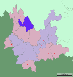 Location of Lijiang City jurisdiction in Yunnan | |
 Lijiang Location in China | |
| Coordinates: 26°53′N 100°14′E / 26.883°N 100.233°E | |
| Country | People's Republic of China |
| Province | Yunnan |
| Admin HQ | Gucheng |
| Area | |
| • Prefecture-level city | 21,219 km2 (8,193 sq mi) |
| • Urban | 1,127 km2 (435 sq mi) |
| • Metro | 1,127 km2 (435 sq mi) |
| Elevation | 2,400 m (7,900 ft) |
| Population (2010 census) | |
| • Prefecture-level city | 1,244,769 |
| • Density | 59/km2 (150/sq mi) |
| • Urban | 155,540 |
| • Urban density | 140/km2 (360/sq mi) |
| • Metro | 155,540 |
| • Metro density | 140/km2 (360/sq mi) |
| Time zone | China Standard (UTC+8) |
| Postal code | 674100 |
| Area code(s) | 0888 |
| Licence plate prefixes | 云P |
| Website |
lijiang |
| Lijiang | |||||||||||||||||||||
|
"Lijiang" in Simplified (top) and Traditional (bottom) Chinese characters | |||||||||||||||||||||
| Simplified Chinese | 丽江 | ||||||||||||||||||||
|---|---|---|---|---|---|---|---|---|---|---|---|---|---|---|---|---|---|---|---|---|---|
| Traditional Chinese | 麗江 | ||||||||||||||||||||
| |||||||||||||||||||||
.svg.png)
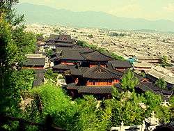
Lijiang (in Chinese: 丽江; pinyin: Lì jiāng) is a prefecture-level city in the northwest of Yunnan province, China. It has an area of 21,219 square kilometres (8,193 sq mi) and had a population of 1,244,769 at the 2010 census. Lijiang is famous for its UNESCO Heritage Site, the Old Town of Lijiang.
History
Lijiang City replaced the former administrative region of Lijiang Naxi Autonomous Prefecture. It was under the rule of the Mu family (木氏) local commanders (土司) during the Ming Dynasty and Qing Dynasty.[1]
The Baisha Old Town was the political, commercial and cultural center for the local Naxi people and other ethnic groups for 400 years from the year 658 AD to 1107 AD. The Dabaoji Palace of the Baisha Fresco, very close to the Baisha Naxi Hand-made Embroidery Institute, was built in the year 658 AD in the Tang Dynasty (618 AD to 960 AD).
In ancient times, the Baisha Old Town used to be the center of silk embroidery in the southwest of China and the most important place of the Ancient Southern Silk Road, also called the Ancient Tea and Horse Road or Ancient tea route.[2] The Ancient Southern Silk Road started from Burma, crossed Lijiang, Shangri-La County, Tibet, journeyed through Iran, the Fertile Crescent, and ultimately to the Mediterranean Sea.
Administrative divisions
The government of Lijiang City sits in Gucheng District.
Lijiang City comprises one district and four counties:
| Map | ||||||
|---|---|---|---|---|---|---|
| # | Name | Hanzi | Hanyu Pinyin | Population (2003 est.) | Area (km²) | Density (/km²) |
| 1 | Gucheng District | 古城区 | Gǔchéng Qū | 140,000 | 1,127 | 124 |
| 2 | Yongsheng County | 永胜县 | Yǒngshèng Xiàn | 380,000 | 5,099 | 75 |
| 3 | Huaping County | 华坪县 | Huápíng Xiàn | 150,000 | 2,266 | 66 |
| 4 | Yulong Nakhi Autonomous County | 玉龙纳西族自治县 | Yùlóng Nàxīzú Zìzhìxiàn | 210,000 | 6,521 | 32 |
| 5 | Ninglang Yi Autonomous County | 宁蒗彝族自治县 | Nínglàng Yízú Zìzhìxiàn | 240,000 | 6,206 | 39 |

Geography
Lijiang is located in the northwestern portion of Yunnan and borders Sichuan. It is in a region where the Qinghai-Tibet Plateau and Yunnan-Guizhou Plateau converge.
Owing to its low latitude and high elevation, the city centre of Lijiang experiences a mild subtropical highland climate (Köppen Cwb). Winters are mild and very dry and sunny (>70% possible sunshine), although average lows in December and January are just below the freezing mark; January, the coolest month, with 24-hour average temperature of 6.0 °C (42.8 °F). Spring begins early and remains dry and sunny until late May, when there is a dramatic uptick in frequency and amount of rainfall that lasts until late September. Summers are warm, rainy (more so than it is sunny) and damp, with June, the warmest month, averaging 18.4 °C (65.1 °F). Autumn sees an abrupt reduction in rainfall and return to sunniness. The annual mean temperature is 12.70 °C (54.9 °F), while precipitation averages 968 mm (38.1 in), around 80% of which occurs from June to September. With monthly percent possible sunshine ranging from 32% in July to 80% in December, the city receives 2,463 hours of bright sunshine annually.
| Climate data for Lijiang, Yunnan (1971−2000) | |||||||||||||
|---|---|---|---|---|---|---|---|---|---|---|---|---|---|
| Month | Jan | Feb | Mar | Apr | May | Jun | Jul | Aug | Sep | Oct | Nov | Dec | Year |
| Average high °C (°F) | 13.5 (56.3) |
14.7 (58.5) |
17.1 (62.8) |
20.0 (68) |
23.2 (73.8) |
24.0 (75.2) |
23.1 (73.6) |
22.7 (72.9) |
21.3 (70.3) |
20.0 (68) |
16.9 (62.4) |
14.4 (57.9) |
19.2 (66.6) |
| Average low °C (°F) | −0.2 (31.6) |
2.0 (35.6) |
4.8 (40.6) |
7.8 (46) |
11.1 (52) |
14.3 (57.7) |
14.5 (58.1) |
13.6 (56.5) |
12.2 (54) |
8.7 (47.7) |
3.5 (38.3) |
−0.1 (31.8) |
7.7 (45.8) |
| Average precipitation mm (inches) | 2.3 (0.091) |
5.8 (0.228) |
16.7 (0.657) |
21.0 (0.827) |
55.8 (2.197) |
167.3 (6.587) |
242.2 (9.535) |
206.3 (8.122) |
160.8 (6.331) |
70.0 (2.756) |
16.0 (0.63) |
3.8 (0.15) |
968.0 (38.11) |
| Average precipitation days (≥ 0.1 mm) | 1.9 | 3.9 | 6.6 | 7.9 | 11.7 | 20.3 | 24.2 | 22.3 | 20.8 | 11.5 | 4.3 | 1.5 | 136.9 |
| Average relative humidity (%) | 46 | 46 | 49 | 54 | 59 | 73 | 81 | 83 | 83 | 73 | 62 | 53 | 63.5 |
| Mean monthly sunshine hours | 259.9 | 229.7 | 248.4 | 233.4 | 225.1 | 156.7 | 134.2 | 155.0 | 138.8 | 195.2 | 226.6 | 260.3 | 2,463.3 |
| Percent possible sunshine | 79 | 73 | 67 | 61 | 54 | 38 | 32 | 38 | 38 | 55 | 70 | 80 | 56 |
| Source: China Meteorological Administration | |||||||||||||
Transport
- Lijiang Airport (LJG); Lijiang Airport is located in the south of Lijiang city, 28 km (17 mi) away from downtown. There is an airport shuttle bus service in downtown Lijiang. The airport was opened in July 1995 and has flights to Kunming, Chengdu, Xishuangbanna, Beijing, Shanghai, Guangzhou, Wuhan, Shenzhen, Xiamen via Chongqing and Guiyang. It also offers chartered airplane service. There are flights from Kunming to Lijiang every day and is about 30 minutes flight time.
- There are bus services to, amongst others, Kunming (8 hrs), Dali (3 hrs), the Tiger Leaping Gorge and Shangri-La.
- There is a train service to Kunming with one overnight and two day trains, and one day train to Dali.
- Lijiang has several bridges over the Jinsha River, including the Jinlong Bridge, built in 1936, the oldest over the Yangtze.
Old Town
.jpg)
Nearby
Some tens of miles north of Lijiang is the Baishui Terrace (白水台 Baishuitai, literally "White Water Terrace"), an area where spring water flows over a sinter terrace, leaving behind travertine. Lijiang is also close to the Jade Dragon Snow Mountain (玉龙雪山).
A few miles north of Lijiang is the village of Baisha, famous for the Baisha Fresco and the Naxi Hand-made Embroidery Institute.The Fresco was built in the Ming Dynasty 600 years ago, the Naxi Hand-made Embroidery Institute was built 800 years ago, it is the headquarters of the Naxi embroideries and also, a school for the Naxi embroiderers. There are many Naxi embroidery masters, teachers, students and local farmers there. Their embroidery arts can be found there.
Sister Cities
-
 Kazan, Tatarstan, Russia [3]
 -
 Roanoke, Virginia, United States
 -
 New Westminster, British Columbia, Canada
 -
 Takayama, Gifu, Japan
 -
 Shepparton, Victoria, Australia
See also
- Riding Alone for Thousands of Miles: a film by Zhang Yimou which takes place in the Lijiang area
References
- ↑ 丽江木氏土司与滇川藏交角区域历史文化研讨会综述
- ↑ Forbes, Andrew ; Henley, David (2011). China's Ancient Tea Horse Road. Chiang Mai: Cognoscenti Books. ASIN: B005DQV7Q2
- ↑ Successful use of heritage is the pledge of prosperous future of Euro-Asia Cities (DOC file). II International Conference of World Heritage Cities of Euro-Asia. Lijiang. 15–18 October 2006 Archived February 26, 2009, at the Wayback Machine.
External links
| Wikimedia Commons has media related to Lijiang. |
- Lijiang City Official website
 Lijiang travel guide from Wikivoyage
Coordinates: 26°53′N 100°14′E / 26.883°N 100.233°E
Yunnan topics | |
|---|---|
| General | |
| Geography | |
| Education | |
| Culture | |
| Cuisine |
|
| Visitor attractions | |
| |
| East |
|  |
|---|---|---|
| South Central |
| |
| Southwest | ||
| North | ||
| Northeast | ||
| Northwest | ||
| Multiple regions | ||