Lennox Bridge, Blaxland
| Lennox Bridge | |
|---|---|
 The oldest surviving stone arch bridge on the Australian mainland | |
| Coordinates | 33°45′15″S 150°37′56″E / 33.75417°S 150.63222°ECoordinates: 33°45′15″S 150°37′56″E / 33.75417°S 150.63222°E |
| Carries | Light Motor vehicles, pedestrians and bicycles |
| Locale | Blaxland, New South Wales, Australia |
| Characteristics | |
| Design | Arch Bridge |
| Material | Stone |
| Width | 9 metres (30 ft) [1] |
| Height | 9 metres (30 ft) at highest point [1] |
| Longest span | 6 metres (20 ft) [1] |
| No. of spans | 1 [1] |
| Load limit | 2 tonne limit [2] |
| History | |
| Designer | David Lennox |
| Construction start | 1832 [2] |
| Construction end | 1833 [1] |
| Opened | 1833 [1] |
| Closed | 1967-1982 [2] |
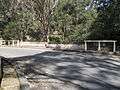
The Lennox Bridge (also known as The Horseshoe Bridge) is a stone arch bridge designed by David Lennox situated in Blaxland, New South Wales, Australia. It is a single arch of 6 metres (20 ft) span and 9 metres (30 ft) above water level, with a road width of 9 metres (30 ft).[1]
History and description
Lennox Bridge, opened in 1833, is the oldest surviving stone arch bridge on the Australian mainland.[3][4] It crosses Brookside Creek (also known as Lapstone Creek) on the road known as Mitchells Pass. It replaced an earlier crossing of the creek 600 metres (2,000 ft) further south, which today survives as a walking track. A nearby quarry is thought to have been created for the purpose of providing stone for the bridge.[2]
The bridge served the main route to the Blue Mountains for 93 years until 1926, when the Great Western Highway was re-routed via the Knapsack Viaduct.[5] It was closed in 1967 but later strengthened and repaired with an internal concrete structure and it re-opened in 1982.[2][4]
Gallery

See also
Historic bridges of New South Wales
References
- 1 2 3 4 5 6 7 "Australian Dictionary of Bibliography - David Lennox". Retrieved 2010-11-07.
- 1 2 3 4 5 Blue Mountains City Council Report
- ↑ Glenbrook Chamber
- 1 2 http://www.engheritage-sydney.org.au/PDFs/Mitchell's.pdf
- ↑ "Lennox Bridge, Mitchell's Pass, Lapstone Hill". Blue Mountains, Australia, History. David Martin. 2003. Retrieved 7 October 2013.
| Wikimedia Commons has media related to Lennox Bridge, Blaxland. |
| Wikimedia Commons has media related to Lennox Bridge, Glenbrook. |