Leine
| Leine | |
|---|---|
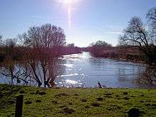 The Leine near Sarstedt-Ruthe | |
| Country |
|
| States | Thuringia, Lower Saxony |
| Reference no. | DE: 488 |
| Basin features | |
| Main source |
In Leinefelde in the Eichsfeld 340 m above sea level (NN) |
| River mouth |
Near Schwarmstedt into the Aller at km 52.26[1] 25 m above sea level (NN) 52°43′22″N 9°35′38″E / 52.72278°N 9.59389°ECoordinates: 52°43′22″N 9°35′38″E / 52.72278°N 9.59389°E |
| Progression | Aller → Weser → North Sea |
| River system | Weser |
| Basin size | 6,512 km2 (2,514 sq mi) |
| Landmarks | |
| Tributaries | |
| Physical characteristics | |
| Length | 281 km (175 mi) |
| Discharge |
|
| Discharge (location 2) |
|
| Discharge (location 3) |
|
| Discharge (location 4) |
|
The Leine (German: [ˈlaɪnə]; Old Saxon Lagina) is a river in Thuringia and Lower Saxony, Germany. It is a left tributary of the River Aller (and of the River Weser, as well) and 281 km (175 mi) long.
The river's source is located close to the town of Leinefelde in Thuringia. About 40 km (25 mi) downriver, the river enters Lower Saxony and runs northwards.
Important towns upstream to down along its course are Göttingen, Einbeck, Alfeld, and Gronau, before the river enters Hanover, the largest city on its banks. Downstream some 40 km (25 mi) north of Hanover, near Schwarmstedt, the river joins the Aller and reaches the North Sea via the Weser. Only in its northern (lower) reaches is it navigable by today's smallest commercial carriers, though in the past, it served as an important prerailway barge transport artery as far upriver as Göttingen.
The river is somewhat polluted from industries, so is not used for drinking water, but the pollution was never severe enough to prevent fish from living in it. Like many western rivers since the 1960s, it has enjoyed successively cleaner waters since the implementation of environmental controls. People enjoy sport fishing from small boats and along the banks, although yields are normally low.
At least one point (Göttingen) of the river is partially diverted into a canal that runs more or less parallel to the river.
In his 1986 bestseller Red Storm Rising, author Tom Clancy uses the Leine as a major obstacle to the Soviet Union's Red Army in its drive to the River Rhine and the North Sea ports of the Netherlands and Belgium through West Germany.
References
- ↑ Längen (in km) der Hauptschifffahrtswege (Hauptstrecken und bestimmte Nebenstrecken) der Binnenwasserstraßen des Bundes, Wasser- und Schifffahrtsverwaltung des Bundes
Further reading
- Uwe Schmida: Die Leine - Eine fotografische Reise. ISBN 3-00-020567-5
- Gerd Lüttig: Neue Ergebnisse quartärgeologischer Forschung im Raume Alfeld-Hameln-Elze. In: Geologisches Jahrbuch Band 77, Seite 337–390. Hannover, Juni 1960.
External links
-
 Media related to Leine at Wikimedia Commons
 - Bundesamt für Naturschutz: Landschaftssteckbrief "Leine-Ilme-Senke"
- Bundesamt für Naturschutz: Landschaftssteckbrief "Leine-Niederung"