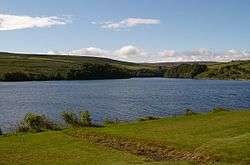
Leighton Reservoir
| Leighton Reservoir | |
|---|---|
 | |
| Location | North Yorkshire |
| Coordinates | 54°12′11″N 1°45′24″W / 54.20306°N 1.75667°WCoordinates: 54°12′11″N 1°45′24″W / 54.20306°N 1.75667°W |
| Type | reservoir |
| Basin countries | United Kingdom |
| Water volume | 5,000,000 litres (1,099,846.241 imp gal; 1,320,860.262 US gal)[1] |
Leighton Reservoir is a reservoir which drains via the River Burn to the River Ure in North Yorkshire, England. It neighbours Roundhill Reservoir and is about 4 miles (6.4 km) west of Masham. It takes its name from the nearby village of Leighton.
Water from the reservoir is used to compensate for abstraction from the River Ure.[2]
Although not in Nidderdale, the reservoir is within the Nidderdale Area of Outstanding Natural Beauty.[2]
Leighton is accessible for fishing and has a car park. The reservoir is on land owned by the Swinton Estate and they stock the waters with fish.[3]
Like its near neighbours in Upper Nidderdale, the construction of Leighton reservoir (and Roundhill) necessitated the building of an industrial railway to bring in materials for construction. A 2 ft (610 mm) 6-mile (9.7 km) railway was built from the north end of Masham railway station where a transhipment yard was located to transfer freight between the narrow and standard gauge lines. The line opened in 1905 and was closed by 1930.[4]
References
- ↑ "Leighton reservoir works to take nine months". Ripon Gazette. 17 March 2013. Retrieved 24 December 2016.
- 1 2 Nidderdale AONB website
- ↑ "Rivers and Reservoirs on the Swinton Estate". www.theswintonestate.com. Retrieved 24 December 2016.
- ↑ "Disused Stations: Masham Station". www.disused-stations.org.uk. Retrieved 24 December 2016.