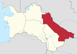
Lebap Region
Coordinates: 39°0′N 63°0′E / 39.000°N 63.000°E
| Lebap | |
|---|---|
| Region | |
 Lebap region in Turkmenistan | |
| Country | Turkmenistan |
| Capital | Türkmenabat |
| Area | |
| • Total | 93,730 km2 (36,190 sq mi) |
| Population (2005) | |
| • Total | 1,334,500 |
| • Density | 14/km2 (37/sq mi) |
Lebap Region (Turkmen: Lebap welaýaty from the Persian لب آب Lab-i āb) is one of the regions of Turkmenistan. It is in the northeast of the country, bordering Afghanistan, Uzbekistan along the Amu Darya. Its capital is Türkmenabat (formerly named Çärjew). It has an area of 93,730 square kilometers, and a population of 1,334,500 people (2005 est.).[1]
The name Lebap is Turkmenized form of the Persian Lab-i āb (لب آب) which means "riverside" and has long been used to designate the middle reaches of the Amu Darya river.[2]
It contains the Repetek Nature Reserve and the Köýtendag Nature Reserve, which has Turkmenistan's highest mountain, Aýrybaba (3137 meters).
Region is located alongside of Amuderya river, Gyzylgum desert is located east side of river and Garagum desert is located west side of river. Thanks to sunny whether and abundance of water resources state produced one of the highest quality cotton and wheat in the world.
Region is also rich for its natural resources such as natural gas and other mines. China-Turkmenistan gas-pipeline started from this region. Lebap Regions Bagtiyarlik natural gas field is main supplier of Chinese natural gas.
Districts
Lebap Region is divided into 16 districts (etraplar; singular etrap) and 3 cities (il).[3][4] Name changes since 1995 are shown in parentheses:
- Districts
- Atamyrat District (formerly Kerki District)
- Beýik Türkmenbaşy District (formerly Dostlyk District)
- Birata District (formerly Darganata District)
- Döwletli District (created in August 2007)[5][6]
- Farap District
- Galkynyş District (formerly Dänew District)
- Garabekewül District
- Garaşsyzlyk District (formerly Boýnyuzyn District)
- Halaç District
- Hojambaz District
- Köýtendag District (formerly Çarşaňňy District)
- Sakar District
- Saýat District
- Serdarabat District (formerly Türkmenabat/Çärjew District)
- Seýdi District
- Cities
- Magdanly City (formerly Gowurdak)
- Seýdi City
- Türkmenabat City (formerly Çärjew)
- Atamyrat
References
- ↑ Statistical Yearbook of Turkmenistan 2000-2004, National Institute of State Statistics and Information of Turkmenistan, Ashgabat, 2005.
- ↑ UNESCO., Ahmad Hasan Dani, and V. M. Masson. 1992. History of civilizations of Central Asia. Vol. V. Paris: Unesco. p.128
- ↑ Лебапский Велаят
- ↑ Turkmenistan Districts
- ↑ Dovletli: a new etrap in Lebap Province (in Russian). Retrieved on 24 January 2009.
- ↑ Presidential resolution on Dovleti Etrap, 29 August 2007. Retrieved on 24 January 2009.
