Siemianowice Śląskie
| Siemianowice Śląskie | |||
|---|---|---|---|
|
City Council | |||
| |||
 Siemianowice Śląskie | |||
| Coordinates: 50°16′33″N 18°59′9″E / 50.27583°N 18.98583°E | |||
| Country |
| ||
| Voivodeship |
| ||
| County | city county | ||
| Established | 13th century | ||
| Town rights | 1932 | ||
| Government | |||
| • Mayor | Rafał Piech | ||
| Area | |||
| • City | 25.5 km2 (9.8 sq mi) | ||
| Highest elevation | 295 m (968 ft) | ||
| Lowest elevation | 260 m (850 ft) | ||
| Population (2013) | |||
| • City | 69,713 | ||
| • Density | 2,700/km2 (7,100/sq mi) | ||
| • Urban | 2,746,000 | ||
| • Metro | 4,620,624 | ||
| Time zone | CET (UTC+1) | ||
| • Summer (DST) | CEST (UTC+2) | ||
| Postal code | 41-100 to 41-106 | ||
| Area code(s) | +48 32 | ||
| Car plates | SI | ||
| Website | http://www.um.siemianowice.pl | ||


Siemianowice Śląskie also known as Siemianowice (Polish pronunciation: [ɕɛmjanɔˈvit͡sɛ ˈɕlɔ̃skʲɛ]; German: Siemianowitz-Laurahütte; Silesian: Śymjanowicy) is a city in Upper Silesia in southern Poland, near Katowice, in its central district in the Upper Silesian Metropolitan Union - a metropolis with a population of 2 million people and is located in the Silesian Highlands, on the Brynica river (tributary of the Vistula).
It is situated in the Silesian Voivodeship since its formation in 1999, previously in Katowice Voivodeship, and before then in the Autonomous Silesian Voivodeship. Siemianowice is one of the cities of the 2.7 million conurbation, the Katowice urban area, at the heart of the greater Silesian metropolitan area populated by about 5,294,000 people.[1] The population of the city is 71,621 (2008).[2]
Siemianowice's present form results from the merging of the communes Siemianowice and Huta Laury (German: Laurahütte) in 1924. The new city was named Siemianowice Śląskie and gained town privileges in 1932.
Etymology
There are three hypothetical explanations for the origins of the name Siemianowice: either it comes from seven huts which were called Siedminowice/Siedmionowice in Old Polish; from the old legend about Siemion (Siemian), Michał and Maciej, or Siemion, Michał and Jakub; or it comes from ziemia nawa which means earth taken away from water.
According to the most probable version the three settelments on Rosperk's (Rozbark) southern perimeter were founded by Siemion Spyra - Siemianowice, Michał Spyra - Michałkowice and Maciej Spyra - Maciejkowice, members of an ancient noble family (Pernus coat of arms) living in Rosperk (Bytom-Rozbark), and some other cities, e.g. Kraków, Oława, Racibórz, Opole, Pěrno (Pirna), Spira (Querfurt-Kyffhäuser-Esperstedt), Spira (Speyer)… The ancient family was first mentioned in German sources of 777 as rulers of Alpine Slavs, where Spyra is recorded in its form of Sperun, as used by Żercy-Žrecy (pagan priests) of Perun. The name Siemion (Семион) Spyra (Спира) was reported by imperial Russian sources after the Napoleonic Wars, after many members of the family, due to German oppression, moved to Congress Poland (just across the river Brynica).[3]
The silver mines of Rosperk were reported 1136 in the Bull of Gniezno as Item villa ante Bitom…argenti fossoribus… and in 1241, while the Mongol invasion of Europe, looted by Turko-Mongol troops of Batu Khan. From looted silver the famous massive Silver Tree of Karakorum was built.
Administrative division
- Centrum - 11,98 km²
- Michałkowice - 5,46 km²
- Bańgów - 2,96 km²
- Przełajka - 2,7 km²
- Bytków - 2,3 km²
Industry
- Johnson Controls (
 USA, Car Parts Manufacturing)
 - Arcelor Mittal (
 Luxembourg, Steel Manufacturing)
 - Fastening Elements Factory (
 Poland, Fastening Hardware Manufacturing)
 - Rosomak S.A. ( Poland, Defence Systems)
- Fabud ( Poland, Building Company)
- Huhtamäki (
 Finland, Specialty Packaging Products)
Notable architectural structures
- Bytków TV Tower
- Palace of the Donnersmarcks
- Zameczek Palace
- Archangel Michael's Church
- The Townhall
- The Brewery
International relations
Twin towns — Sister cities
Siemianowice Śląskie is twinned with: Köthen, Wattrelos, Jablunkov, Mohács, Câmpia Turzii
Famous people
- Apostolis Anthimos (born 1954), musician
- Barbara Blida (1949–2007), Polish politician
- Antoni Halor (born 1937), Polish film director, artist, writer
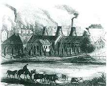
- Hugo Henckel von Donnersmarck (1811–1890), German industrialist, founder of Laurahütte
- Jacek Fröhlich (born 1965), Automotive Designer, BMW exterior design chief
- Michael Jary (1906–1988), German composer
- Bronisław Korfanty (born 1952), Polish senator
- Wojciech Korfanty (1873–1939), Polish politician
- Hermański Kryspin (born 1984), Polish dancer
- Zygmunt Maszczyk (born 1945), Polish footballer
- Daniel Podrzycki (1963–2005), Polish politician
- Otto Josef Schlein (1895–1944), German doctor
- Józef Skrzek (born 1948), musician, leader of SBB band
- Henryk Średnicki (born 1955), Olympic boxer
- Ernst Steinitz (1871–1928, German mathematician
- Witold Ziaja (born 1940), Polish field hockey player
- Krzysztof Globisz (born 1957, Polish actor
References
- ↑ European Spatial Planning Observation Network (ESPON)
- ↑ Powierzchnia i ludność w przekroju terytorialnym w 2008 - Central Statistical Office in Poland ISSN 1505-5507 , 13.08.2008
- ↑ "Герб рода Иосифа-Мариана Спира, Часть 14 Общего гербовника дворянских родов Всероссийской империи, стр. 19". gerbovnik.ru.
- This article may be expanded with text translated from the corresponding article in the Polish Wikipedia (December 2008)
External links
- Jewish Community in Siemianowice Śląskie on Virtual Shtetl
- Sights
- Old photos
| City counties |  | |
|---|---|---|
| Land counties | ||
Coordinates: 50°19′N 19°02′E / 50.317°N 19.033°E