Coburg (district)
| Coburg | |
|---|---|
| District | |
.svg.png) | |
| Country |
|
| State | Bavaria |
| Adm. region | Upper Franconia |
| Capital | Coburg |
| Area | |
| • Total | 592 km2 (229 sq mi) |
| Population (31 December 2015)[1] | |
| • Total | 86,599 |
| • Density | 150/km2 (380/sq mi) |
| Time zone | CET (UTC+1) |
| • Summer (DST) | CEST (UTC+2) |
| Vehicle registration | CO, NEC |
| Website | landkreis-coburg.de |
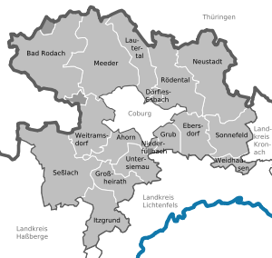
Coburg is a Landkreis (district) in Bavaria, Germany. It is bounded by (from the east and clockwise) the districts of Kronach, Lichtenfels, Bamberg and Haßberge, and by the state of Thuringia (districts Hildburghausen and Sonneberg). The district surrounds, but does not include the city of Coburg.
History
The history of the district is largely influenced by the city of Coburg. From 1826 to 1918, the region was part of the small duchy of Saxe-Coburg-Gotha (see Thuringia). In a referendum from 1919, the Coburg portion of this state decided to join Bavaria (united in 1920). The present district is identical to that portion, but excludes the city of Coburg and the exclave of Königsberg, which is part of Haßberge district. The city of Neustadt was a district-free city until 1972 and was then incorporated into the district.
Geography
The district is located in the hilly country between the Thuringian Slate Mountains and the Main valley.
Coat of arms
 |
The arms consist of the blue and white checkered pattern of Bavaria and the arms of the Wettin dynasty of Saxony. These arms represent the historic affiliations to both states. |
Towns and municipalities

| Towns | Municipalities | |
|---|---|---|
References
- ↑ "Fortschreibung des Bevölkerungsstandes". Bayerisches Landesamt für Statistik und Datenverarbeitung (in German). June 2016.
External links
| Wikimedia Commons has media related to Landkreis Coburg. |
- Official website (German)
Coordinates: 50°16′N 10°55′E / 50.267°N 10.917°E