Lakewood Heights, Dallas
Lakewood Heights is a residential neighborhood in Dallas, Texas (USA), bounded by Abrams Road to the east, Monticello Avenue to the north (not McCommas, as incorrectly shown on Google Maps), Skillman Street to the west, and Richmond Avenue to the south.[1] It is in the area known as East Dallas. Lakewood Heights is approximately one-half mile (0.8 km) wide (east-west) and three-quarters of a mile (1.2 km) long (north-south). It covers approximately 240 acres or slightly less than 0.375 square miles (1000m²). It is adjacent to several East Dallas neighborhoods, including Lakewood, Lower Greenville, and Wilshire Heights.[2]
The area now comprising Lakewood Heights is part of three land grants made in the 1850s by the State of Texas to, respectively, Amon (a/k/a Amos) McCommas (Abstract 911), John McCommas, probably the son of Amon and Mary McCommas (Abstract 943), and Allen Beard (Abstract 66).[3] Amon McCommas, his wife Mary Brumphield McCommas, and their nine children settled on this land in 1844.[4] McCommas Boulevard, just north of Lakewood Heights, is named for the McCommas family.[5] Beard's Branch, a creek draining into White Rock Lake east of Lakewood Heights may have been named for Allen Beard.
Lakewood Heights was first platted in 1914, and development was substantially completed in 1940,[6] although a few streets date from 1949-50. Building lot sizes typically are 50 to 60 feet wide and between 140 and 220 feet deep.[7] As a neighborhood, Lakewood Heights predates neighboring Lakewood, as shown by aerial photographs of the area taken in 1923.[8] A 1919 street map shows that the first streets platted were those between Llano Avenue on the north and Richmond on the south.[9]

Lakewood Heights comprises portions of Dallas County census tracts 2.01[10] and 11.02[11] in the 2010 U.S. federal census.[12] According to D Magazine (citing Nielsen SiteReports and samplings based on most recent U.S. census estimates[13]): the population of Lakewood Heights is 2,343; there are 1,060 households in the neighborhood; the average household size is 2.21 persons; 65.4% of houses are owner-occupied; and the median value for owner-occupied houses in Lakewood Heights is $397,526. The median age is 36.9 years; 54.1% of residents are married, 3.4% are widowed, and 12.2% are divorced. The racial make-up of the neighborhood is: 91.3% white (9.4% are of Hispanic heritage), 1.5% African-American, 2.5% Asian, and 4.7% identify as some other race. Among those age 25 and older, 39.0% hold a bachelor’s degree, 20.4% a master’s degree, 7.9% a professional school degree, and 4.7% a doctorate.
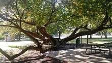
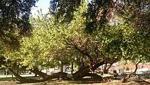
Tietze Park, a 9-acre public park owned and operated by the city of Dallas, is located on the western edge of Lakewood Heights on Skillman Avenue between Llano and Vanderbilt Streets. The park was acquired in 1924 by the City of Dallas. It is named after W.R. Tietze, who was Dallas' Superintendent of Parks from 1896-1933. The park contains a sandstone picnic pavilion dating from 1934, a community swimming pool, lighted baseball field, tennis court, basketball court, serpentine walking/jogging paths, other recreation and picnic areas,[14] and more than 75 red oak, live oak, and cedar trees, and a few “kneeling” bois d'arc trees, which are said to predate the park by 50 years or more.[15] The Friends of Tietze Park Foundation is a registered nonprofit organization whose mission is the improvement, preservation and continued beautification of Tietze Park.[16] In 2009, Preservation Dallas[17] recognized the Friends of Tietze Park Foundation with a preservation achievement medal for the Best Rehabilitation of a Historic Landscape or Park.[18] For more information on Tietze Park, refer to articles at the Flashback Dallas[19] and the Lakewood Advocate[20] websites.
Lakewood Heights is in the Dallas Independent School District attendance zones for Robert E. Lee Elementary School, Stonewall Jackson Elementary School, J.L. Long Middle School, and Woodrow Wilson High School.[13] It is part of Dallas City Council District 14.[21]
References
- ↑ http://lakewoodheights.org/ Lakewood Heights Neighborhood Association
- ↑ Dallas Neighborhoods Map (#176)
- ↑ https://www.tsl.texas.gov/cgi-bin/aris/maps/maplookup.php?mapnum=1219 / Sam Streets Map of Dallas County, 1900. Texas State Archives Map Collection
- ↑ Memorial and Biographical History of Dallas County, Texas, p.960
- ↑ History of the Restoration Movement
- ↑ http://www.preservationdallas.org/resources/discover-dallas/lakewood-heights/ Preservation Dallas
- ↑ http://dcadmaps.dallascad.org/website/dcad/ Dallas Central Appraisal District Maps
- ↑ Photo: East Dallas-1923-Degolyer Library, Southern Methodist University (Looking generally east: White Rock Lake at top; Swiss Avenue running from right center diagonally to bottom right corner; present-day Abrams Road running from middle of left edge to center of image; and Lakewood Heights west of Abrams (i.e., below Abrams in the image). Note the two massive water tanks, a/k/a standpipes, on Abrams at present-day Goliad.
- ↑ 1919 Map and Guide of Dallas & Suburbs (On the map, Perkins Ave is now Velasco; Gorman: Palo Pinto; Sinex: Lakeshore; Aqueduct: Goliad; Lakewood: Belmont; Withers: Skillman; Jane: Alderson.)
- ↑ USBoundary.com
- ↑ USBoundary.com
- ↑ 2010 U.S. Census Block Map
- 1 2 http://neighborhoods.dmagazine.com/dallas/east-dallas/lakewood-heights/ D Magazine neighborhood guide for Lakewood Heights
- ↑ https://www.yelp.com/biz_photos/tietze-park-dallas/ Photos of Tietze Park on Yelp
- ↑ Friends of Tietze Park Foundation
- ↑ Ibid.
- ↑ [http://www.preservationdallas.org/ Preservation Dallas
- ↑ [http://tietzepark.weebly.com Friends of Tietze Park
- ↑ Bossse, Paula - Flashback Dallas, Tietze Park (2014)
- ↑ Vinson, Patti, "Memories of the Tietze Park Pool," Lakewood Advocate (May 26, 2014)
- ↑ http://dallascityhall.com/government/citycouncil/district14/Pages/default.aspx/
Coordinates: 32°49′16″N 96°45′29″W / 32.821°N 96.758°W