Lake Disappointment
| Lake Disappointment Kumpupirntily | |
|---|---|
|
Landsat image; screen capture from NASA World Wind | |
 | |
| Location | Western Australia |
| Coordinates | 23°30′S 122°50′E / 23.500°S 122.833°ECoordinates: 23°30′S 122°50′E / 23.500°S 122.833°E |
| Lake type | Endorheic salt lake |
| Basin countries | Australia |
| Max. length | 160 km (99 mi) |
| Surface area | 330 km2 (130 sq mi) |
| Surface elevation | 325 metres (1066 ft) |
Lake Disappointment, or Kumpupirntily[1] in the indigenous language, is an endorheic salt lake located in the Pilbara region of Western Australia.
Description
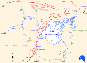
The 33,000-hectare (82,000-acre) lake typically is dry except during very wet periods such as the 1900 floods and in many recent tropical wet seasons since 1967. It lies on the Tropic of Capricorn, due east of the mining town of Newman and the Jigalong Community. It is at the northern side of the Little Sandy Desert and south of the Karlamilyi National Park. The Canning Stock Route passes down the western shores of the lake and the surrounds consist mostly of sand dunes. Its elevation is 325 metres (1066ft) above mean sea level.[2]
In indigenous culture, Kumpupirntily is associated with Nyayurnangalku, cannibalistic spirit beings who live below the surface of the water.[1]
Lake Disappointment was named by the explorer Frank Hann in 1897.[3] Hann was in the area exploring the east Pilbara, around Rudall River. He noticed creeks in the area flowed inland, and followed them, expecting to find a large fresh water lake. The lake turned out to be salted, and consequently was named Lake Disappointment.[4]
The lake is home to many species of waterbirds.[5]
See also
References
- 1 2 "Kumpupirntily (story)". Mira Canning Stock Route Project Archive. FORM in partnership with the Center for Digital Archaeology at University of California, Berkeley. 2013.
- ↑ "Geoscience Australia - ELVIS". Retrieved 2 April 2017.
- ↑ Rothwell, Nicolas (2006). Wings of the kite-hawk. Black Inc. ISBN 978-1-86395-445-7.
- ↑ USGS – Lake Disappointment
- ↑ World Wildlife Fund (2001). "Gibson desert". WildWorld Ecoregion Profile. National Geographic Society. Archived from the original on 2010-03-08.
