Lagoa de Cimidor
| Lagoa de Cimidor | |
|---|---|
| Location | southeastern Maio, Cape Verde |
| Coordinates | 15°09′57″N 23°05′43″W / 15.1657°N 23.0952°WCoordinates: 15°09′57″N 23°05′43″W / 15.1657°N 23.0952°W |
| Type | Lagoon |
| Primary inflows | Ribeira das Tras and do Poço |
| Primary outflows | Ribeira de Cimidor |
| Basin countries | Cape Verde |
| Max. length | 130 km (81 mi) |
| Max. width | 105 km (65 mi) |
| Surface area | 12 ha (30 acres) |
| Average depth | 1 m (3 ft 3 in) |
| Water volume | 0.14 km3 (110,000 acre·ft) |
| Surface elevation | 2 m (6 ft 7 in) |
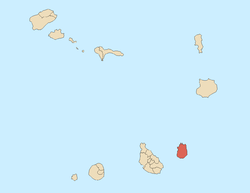
Lagoa de Cimidor is a small lagoon in the southeastern part of the island of Maio in Cape Verde. It is situated east of the island capital Cidade do Maio. It is also a protected area as a Natural Reserve because of its geological value.[1] The nature reserve includes the whole basin and areas between the basin and the sea. Nearby is a thick small beach 700 meters northeast. About 1.8 km northeast is the island's easternmost point. Over 3 km SSW is the village of Ribeira Dom João.
In the middle is Ribeira da Tras (or Ribeira da Tráz), 80 meters northwest has a small tributary with Ribeira do Poço and empties into the lagoon, the tributary's elevation is about 5 meters. The first stream's length is 2 km and the second is slightly longer at around 2 km, its source is about 55 meters for the first and around 60 meters for the second. Both streams flow east then north then east and southeast, the other flows only east. Ribeira de Cimidor a stream 130 meters long empties into the Atlantic. The shoreline in the area is north-to south length with 25 degrees toward the east.
200 meters northeast is a small track that does not connect the lagoon but its nearby beach with the East Maio Route.
Desert, some grasslands and barren landscape dominates the area, once dominated the whole area, recently in the 1990s, some trees began to appear within the areas of the lagoon, it added some more forested space within that area in the early and mid 2010s.
Northeast is the location being closest to the African mainland from Maio at 599 km (nearly 600 km) west of Cap-Vert in Dakar, Senegal and is not the closest to any part of Cape Verde. Also in that range further east is where current waters and winds enters from the Canary Current into the Equatorial Atlantic Current.
See also
References
Bibliography
- Ricardo A. S. Ramalho, Building the Cape Verde Islands, Springer, 2011
External links
- Áreas protegidas, Cabo Verde (Protected areas of Cape Verde) (in Portuguese)
