Ladd's Addition
|
Ladd's Addition Historic District | |
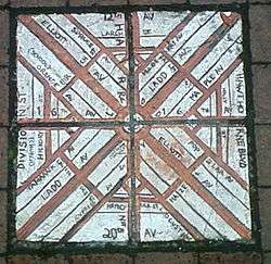
 Brick map of Ladd's Addition at the corner of SE 34th Avenue and SE Madison Street | |
| Location | Portland, Oregon |
|---|---|
| Coordinates | 45°30′31″N 122°38′58″W / 45.508539°N 122.649413°WCoordinates: 45°30′31″N 122°38′58″W / 45.508539°N 122.649413°W |
| Area | 126 acres (0.51 km2) |
| Built | 1905–1930[1] |
| MPS | [lower-alpha 1] |
| NRHP Reference # | 88001310 |
| Added to NRHP | August 31, 1988 |
Ladd's Addition is an inner southeast historic district of Portland, Oregon, United States. It is Portland's oldest planned residential development, and one of the oldest in the western United States.[1] The district is known in Portland for a diagonal street pattern, which is at odds with the rectilinear grid of the surrounding area. Roughly eight blocks (east-west) by ten blocks (north-south) in size (by reference to the surrounding grid), Ladd's is bordered by SE Hawthorne, Division, 12th, and 20th streets. It is part of the Hosford-Abernethy neighborhood association.
History
Ladd's Addition is named after William S. Ladd, a merchant and mid-19th-century Portland mayor who owned a 126-acre (51 ha) farm on the land.[3] In 1891 (when the city of East Portland was merged into Portland) Ladd subdivided the land for residential use.[1] Rather than follow the standard orthogonal grid of the surrounding area, Ladd, inspired by the L'Enfant Plan for Washington, D.C.,[3] created a diagonal "wagon wheel" arrangement, including four small diamond-shaped rose gardens and a central traffic circle surrounding a park. It is also one of the few areas in Portland with alleys, with street elevations mostly uninterrupted by curb cuts.[1]

The homes in the district, mostly developed between 1905 and 1930 (after Ladd's death), have been called a "architecturally rich mix of compatible early 20th century styles", notable for their "continuity of scale, setback, orientation, and materials."[1] Architectural styles represented include bungalow, craftsman, American Foursquare, Mission, Tudor, and Colonial Revival.[1]

Ecology
The narrow streets of Ladd's Addition are lined with American Elm trees. The Save Our Elms organization inoculates the elm trees yearly against Dutch elm disease.[4] Each of the four smaller, diamond-shaped "circles" to the east, west, north, and south contains one of Portland's rose test gardens.[5] Friends of Ladd's Addition Gardens regularly solicits money and volunteers to maintain the rose gardens.[6] Ladd named most of the streets after trees, but he named SE Ladd Avenue and SE Elliott Avenue for himself and his wife, who was born Caroline Elliott.[7]
Historic preservation
The area was designated a historic district by the National Register of Historic Places in 1988.[8]
See also
Notes
References
- General references
- Portland Monthly, April 2007, 20 Best Neighborhoods, pages 78–79.
- Citations
- 1 2 3 4 5 6 "Community History - Ladd's Addition, Portland". Illustrating Four Treatments in Oregon. National Park Service. Retrieved 2012-04-15.
- ↑ McClelland, Linda Flint; Ames, David L.; Pope, Sarah Dillard (December 22, 2004), National Register of Historic Multiple Property Documentation Form: Historic Residential Suburbs in the United States, 1830–1960 (PDF), retrieved December 23, 2016.
- 1 2 "Ladd Circle Park & Rose Gardens". Portland Parks & Recreation. Retrieved 2012-04-15.
- ↑ "History of Save Our Elms". Retrieved 2007-08-30.
- ↑ "Ladd's Addition Rose Garden". Portland Rose Festival Association. Retrieved 2007-08-30.
- ↑ "Friends of Ladd's Addition Gardens". laddsadditiongardens.com. Retrieved 2007-08-30.
- ↑ Snyder, Eugene E. (1979). Portland Names and Neighborhoods. Portland: Binford and Mort. p. 38. ISBN 978-0832303470.
- ↑ "Oregon National Register List" (PDF). oregon.gov. Retrieved 2007-08-30.
External links
-
 Media related to Ladd's Addition, Portland, Oregon at Wikimedia Commons

