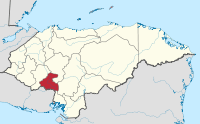
La Paz Department (Honduras)
| La Paz | |
|---|---|
| Department | |
 | |
| Coordinates: 14°20′N 87°41′W / 14.333°N 87.683°WCoordinates: 14°20′N 87°41′W / 14.333°N 87.683°W | |
| Country |
|
| Municipalities | 19 |
| Founded | 1869 |
| Seat | La Paz |
| Government | |
| • Type | Departmental |
| Area | |
| • Total | 2,331 km2 (900 sq mi) |
| Population (2015)[1] | |
| • Total | 206,065 |
| • Density | 88/km2 (230/sq mi) |
| Time zone | -6 |
| Postal code | 15101, 15201 |
La Paz (Spanish pronunciation: [la pas]) is one of the 18 political and geographic departments of Honduras. The departmental capital is the city of La Paz.
The department covers a total surface area of 2,331 km². In 2015, it had an estimated population of 206,065.
Municipalities
- Aguaqueterique
- Cabañas
- Cane
- Chinacla
- Guajiquiro
- La Paz
- Lauterique
- Marcala
- Mercedes de Oriente
- Opatoro
- San Antonio del Norte
- San José
- San Juan
- San Pedro de Tutule
- Santa Ana
- Santa Elena
- Santa María
- Santiago de Puringla
- Yarula
References
- ↑ "GeoHive - Honduras extended". Retrieved 16 January 2015.
External links
-
 Media related to La Paz Department, Honduras at Wikimedia Commons
This article is issued from
Wikipedia.
The text is licensed under Creative Commons - Attribution - Sharealike.
Additional terms may apply for the media files.