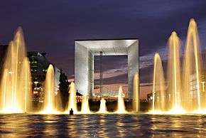
Grande Arche
| Grande Arche de la Défense | |
|---|---|
|
La Grande Arche de la Défense | |
| General information | |
| Type | Office |
| Location | La Défense, Île-de-France, France |
| Coordinates | 48°53′34″N 2°14′09″E / 48.89278°N 2.23583°ECoordinates: 48°53′34″N 2°14′09″E / 48.89278°N 2.23583°E |
| Construction started | 1985 |
| Completed | 1989 |
| Height | 110 m (361 ft) |
| Design and construction | |
| Architect | Johann Otto von Spreckelsen |
La Grande Arche de la Défense (pronounced [la ɡʁɑ̃d aʁʃ də la defɑ̃s]; also La Grande Arche de la Fraternité) is a monument and building in the business district of La Défense and in the commune of Puteaux, to the west of Paris, France. It is usually known as the Arche de la Défense or simply as La Grande Arche.
Design and construction
A great national design competition was launched in 1982 as the initiative of French president François Mitterrand. Danish architect Johann Otto von Spreckelsen (1929–1987) and Danish engineer Erik Reitzel (1941-2012) designed the winning entry to be a late-20th-century version of the Arc de Triomphe: a monument to humanity and humanitarian ideals rather than military victories. The construction of the monument began in 1985. Spreckelsen resigned in July 1986 and ratified the transfer of all his architectural responsibilities to his associate, French architect Paul Andreu. Reitzel continued his work until the monument was completed in 1989.
The Arche is in the approximate shape of a cube (width: 110m, height: 110m, depth: 110m); it has been suggested that the structure looks like a hypercube (a tesseract) projected onto the three-dimensional world.[1] It has a prestressed concrete frame covered with glass and Carrara marble from Italy and was built by the French civil engineering company Bouygues.
La Grande Arche was inaugurated in July 1989, with grand military parades that marked the bicentennial of the French Revolution. It completed the line of monuments that forms the Axe historique running through Paris. The Arche is turned at an angle of 6.33° about the vertical axis. The most important reason for this turn was technical: with a métro station, an RER station, and a motorway all situated directly underneath the Arche, the angle was the only way to accommodate the structure's giant foundations. In addition, from an architectural point of view, the turn emphasizes the depth of the monument and is similar to the turn of the Louvre at the other end of the Axe historique.

In addition, the Arche is placed so that it forms a secondary axe (axis) with the two highest buildings in Paris, the Tour Eiffel and the Tour Montparnasse.
The two sides of the Arche house government offices. The roof section was an exhibition centre, housing the Musée de l'Informatique (Computing Museum). The roof, when it was open to the public, was also popular for its views of Paris. However, after an accident without injury in the elevators in April 2010, the Department of Ecology, owner of the roof of the Grande Arche, decided to permanently close the computer museum, restaurant, and viewing deck. Access to the roof is still possible via the elevators in the north and south walls, but they are closed to the public.[2]
A reopening was planned for May 2017,[3] but was delayed until June 2017.[4]
 View of the Arc de Triomphe from the Grande Arche
 Christmas decoration at the Grand Arche
 The Grande Arche seen from the Arc de Triomphe on the Axe historique
 North façade of the Grande Arche de la Défense
 The Grand Arche seen from the Arc de Triomphe - telephoto lens view
Tenants
Organizations headquartered in the Grande Arche include the Bureau d'Enquêtes sur les Événements de Mer (BEAmer), the French marine accident investigation agency, in the southern (Sud) portion.[5]
See also
References
- ↑ Du Sautoy, Marcus. "A 4 Dimensional Cube in Paris". The Number Mysteries. Retrieved 17 June 2012.
- ↑ Lemonde.fr, Le Monde (11 August 2010)
- ↑ "Monument: Grande Arche de la Défense". Convention and Visitors Bureau Paris. Retrieved 2017-01-10.
- ↑ "Reopening of the Grande Arche rooftop in Paris". www.sortiraparis.com. Retrieved 2017-08-03.
- ↑ "Contact us." Bureau d'Enquêtes sur les Événements de Mer. Retrieved on June 22, 2017. "Bureau d’enquêtes sur les événements de mer (BEAmer) Arche Sud 92055 LA DEFENSE CEDEX FRANCE" - Note the pedestrian access map
Further reading
- François Chaslin et Virginie Picon-Lefebvre, La Grande Arche de La Défense Electa-Moniteur, 1989
- Erik Reitzel Le Cube ouvert. Structures and foundations International conference on tall buildings. Singapore, 1984. ISBN 9971840421
- Erik Reitzel Les forces dont resultent quelques monuments Parisiens de la Fin du XXe siècle Le pouvoir et la ville à l'époque moderne et contemporaine, Sorbonne 2001. ISBN 2747526100
External links
- Grande Arche (French and English)
- Satellite image from Google Maps
- Panorama during a storm
- Grande Arche (in French)
- ERI.dk
- Grande Arche pictures in Art Days

.jpg)