La Belle Alliance

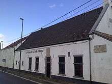
La Belle Alliance is an inn situated a few miles south of Brussels in Belgium, chiefly remembered for its significance in the aftermath of the Battle of Waterloo.
Contemporary use
The building is currently used on Friday and Saturday evenings as a night club.
Battle of Waterloo

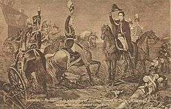
After the Battle of Waterloo, at around 21:00, Prince Blücher and the Duke of Wellington met close to the inn signifying the end of the fighting.[1]
Blücher, the Prussian commander, suggested that the battle should be remembered as la Belle Alliance, to commemorate the European Seventh Coalition of Britain, Russia, Prussia, the Netherlands, Sweden, Austria, Spain, Portugal, Sardinia, and a number of German States which had all joined the coalition to defeat the French Emperor. Wellington, who had chosen the field and commanded an allied army which had fought the French all day, instead recommended Waterloo, the village just north of the battlefield, where he himself had spent the previous night. Nevertheless, in 1815 the Rondell plaza in Berlin was renamed Belle-Alliance-Platz to commemorate the victory.
.jpg) "La Belle Alliance, the centre of the French position". Engraver James Rouse
"La Belle Alliance, the centre of the French position". Engraver James Rouse.jpg) "View of La Belle Alliance". Engraver James Rouse
"View of La Belle Alliance". Engraver James Rouse.jpg) "View of La Belle Alliance". Engraver James Rouse
"View of La Belle Alliance". Engraver James Rouse
Name
According to J.B. Romberg who published an account of the locations around Brussels in 1820, originally La Belle Alliance consisted of three houses, one of which was a tavern, that now bears the name, and two adjacent houses. Some time before the Battle of Waterloo, the publican of the tavern died, and his widow married the occupier of Trimotion, the farm-house opposite; but losing him in a short time afterwards, she consoled herself by taking for her third husband a peasant who lived a house close by (now known as Decoster's house); but here again death interrupted her happiness, when she once more embraced the married state it was to marry the new landlord tavern; from which time it obtained the title it now bears.[2]
Notes
- ↑ Romberg 1820, p. 185.
- ↑ Romberg 1820, p. 186.
References
| Wikimedia Commons has media related to Belle-Alliance. |
- Romberg, J. B. (1820), New picture of Brussels, p. 185–186
External links
- "Ferme de la Belle-Alliance" (in French). http://www.wiki-braine-lalleud.be. 24 October 2015. External link in
|publisher=(help) — historical images of La Belle Alliance
Coordinates: 50°40′6″N 4°24′49″E / 50.66833°N 4.41361°E