Kurucaşile
| Kurucaşile | |
|---|---|
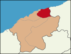
 Location of Kurucaşile District in Bartın Province | |
 Kurucaşile Location of Kurucaşile District in Bartın Province | |
| Coordinates: 41°51′29″N 32°42′59″E / 41.85806°N 32.71639°ECoordinates: 41°51′29″N 32°42′59″E / 41.85806°N 32.71639°E | |
| Country | Turkey |
| Province | Bartın |
| Government | |
| • Mayor | Mehmet Zihni Sayın (AKP) |
| • Kaymakam | Gökhan Gürbüzerol |
| Area[1] | |
| • District | 166.89 km2 (64.44 sq mi) |
| Elevation | 1,500 m (4,900 ft) |
| Population (2012)[2] | |
| • Urban | 1,738 |
| • District | 7,210 |
| • District density | 43/km2 (110/sq mi) |
| Post code | 74500 |
| Climate | Cfb |
| Website | www.kurucasile.bel.tr |
Kurucaşile is a town and district of Bartın Province in the Black Sea region of Turkey. The mayor is Mehmet Zihni Sayın (AKP).
Climate
Köppen-Geiger climate classification system classifies its climate as oceanic (Cfb).[3]
| Climate data for Kurucaşile | |||||||||||||
|---|---|---|---|---|---|---|---|---|---|---|---|---|---|
| Month | Jan | Feb | Mar | Apr | May | Jun | Jul | Aug | Sep | Oct | Nov | Dec | Year |
| Average high °C (°F) | 9 (48) |
10.3 (50.5) |
12.7 (54.9) |
17.1 (62.8) |
21.3 (70.3) |
25.3 (77.5) |
27.5 (81.5) |
27.5 (81.5) |
24.6 (76.3) |
19.7 (67.5) |
15.4 (59.7) |
11 (52) |
18.45 (65.21) |
| Daily mean °C (°F) | 5.1 (41.2) |
6 (43) |
8 (46) |
12.1 (53.8) |
16.2 (61.2) |
19.7 (67.5) |
21.9 (71.4) |
21.8 (71.2) |
18.8 (65.8) |
14.6 (58.3) |
10.7 (51.3) |
7.1 (44.8) |
13.5 (56.29) |
| Average low °C (°F) | 1.2 (34.2) |
1.7 (35.1) |
3.4 (38.1) |
7.2 (45) |
11.1 (52) |
14.2 (57.6) |
16.3 (61.3) |
16.1 (61) |
13 (55) |
9.6 (49.3) |
6.1 (43) |
3.2 (37.8) |
8.59 (47.45) |
| Average precipitation mm (inches) | 91 (3.58) |
66 (2.6) |
58 (2.28) |
53 (2.09) |
49 (1.93) |
52 (2.05) |
51 (2.01) |
64 (2.52) |
63 (2.48) |
90 (3.54) |
101 (3.98) |
111 (4.37) |
849 (33.43) |
| Source: Climate-Data.org, altitude: 3m[3] | |||||||||||||
References
- ↑ "Area of regions (including lakes), km²". Regional Statistics Database. Turkish Statistical Institute. 2002. Retrieved 2013-03-05.
- ↑ "Population of province/district centers and towns/villages by districts - 2012". Address Based Population Registration System (ABPRS) Database. Turkish Statistical Institute. Retrieved 2013-02-27.
- 1 2 "Climate: Kurucaşile - Climate graph, Temperature graph, Climate table". Climate-Data.org. Retrieved 31 August 2013.
This article is issued from
Wikipedia.
The text is licensed under Creative Commons - Attribution - Sharealike.
Additional terms may apply for the media files.
