Kuokkala, Jyväskylä
| Kuokkala | |
|---|---|
| Ward of Jyväskylä | |
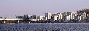
 Kuokkala Bridge connects the district to the downtown | |
| Country |
|
| Province | Western Finland |
| Region | Central Finland |
| Sub-region | Jyväskylä sub-region |
| City | Jyväskylä |
| Ward | Kuokkala |
| Area[1] | |
| • Total | 1,200 ha (3,000 acres) |
| Population (2012) | |
| • Total | 17,000 |
| Time zone | EET (UTC+2) |
| • Summer (DST) | EEST (UTC+3) |
| Postal code | 40520 JYVÄSKYLÄ |
Kuokkala is a ward of Jyväskylä, Finland. It contains six districts: Ristonmaa, Kuokkala, Kuokkalanpelto, Ristikivi, Nenäinniemi and Hämeenlahti.[2] As of July 2012, 17,270 people live in Kuokkala.[3]
The Kuokkala ward is separated from the Jyväskylä city centre by the Lake Jyväsjärvi and is joined to Lutakko by the Kuokkala Bridge. Additionally, it is delimited by the National road 9 on the west, lake Päijänne on the east and the south, and the Äijälänsalmi strait between the two lakes.[2]
History
Kuokkala was consolidated to Jyväskylä on 1 January 1965.[4] Before that it was a part of Jyväskylän maalaiskunta. Planning started in 1973.[4] The construction of residential buildings started in 1981.[5]
A housing fair was held in 1985 in Kuokkala, which received 200.000 visitors.[6]
The Kuokkala bridge was built between 1987 and 1989.[5]
Gallery
- Silent footpaths of Sulkuranta allotment garden
 Kuokkala Church
 Houses in Ainolanranta
 Kuokkala Bridge at night
- A peaceful road on outskirts of Kuokkala
 Apartment houses in Kuokkala
 Tikka School
 Ainolanranta
References
- ↑ Päivänsalo 1992, p. 4.
- 1 2 Jyväskylän opaskartta (Map). City of Jyväskylä. 9 July 2012. Retrieved 15 July 2012.
- ↑ "Tietoja Jyväskylästä suuralueittain". Tietoja Jyväskylästä suuralueittain. City of Jyväskylä. 25 June 2012. Retrieved 14 July 2012.
- 1 2 Päivänsalo 1992, p. 5.
- 1 2 Päivänsalo 1992, p. 6.
- ↑ Päivänsalo 1992, p. 81.
- Literature
- Päivänsalo, Martti (31 December 1992). Kuokkala – Päijänteen helmi: Raportti Jyväskylän Kuokkalan kaupunginosan suunnittelusta ja rakentamisesta v. 1973–1991 (in Finnish). City of Jyväskylä. ISBN 951-9164-16-2.
External links
![]() Media related to Kuokkala, Jyväskylä at Wikimedia Commons
Media related to Kuokkala, Jyväskylä at Wikimedia Commons
- Website of Kuokkala Inhabitant Association (in Finnish)
- Taikalamppu Day Care Centre in Kuokkala
- Peukkula Adventure Park
Coordinates: 62°13′22″N 25°46′39″E / 62.22278°N 25.77750°E