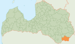
Krāslava Municipality
| Krāslava Municipality Krāslavas novads | |||
|---|---|---|---|
| Municipality | |||
| |||
 | |||
| Country |
| ||
| Formed | 2001 | ||
| Centre | Krāslava | ||
| Government | |||
| • Mayor | Gunārs Upenieks | ||
| Area[1] | |||
| • Total | 1,078.4 km2 (416.4 sq mi) | ||
| Population (2009)[2] | |||
| • Total | 20,217 | ||
| • Density | 19/km2 (49/sq mi) | ||
| Website |
www | ||
Krāslava Municipality (Latvian: Krāslavas novads, Latgalian: Kruoslovys nūvods) is a municipality in Latgale, Latvia. The municipality was formed in 2001 by merging Krāslava parish and Krāslava town. In 2009 it absorbed Auleja parish, Indra parish, Izvalta parish, Kalnieši parish, Kaplava parish, Kombuļi parish, Piedruja parish, Robežnieki parish, Skaista parish and Ūdrīši parish town the administrative centre being Krāslava.
Demographics
Ethnic composition
As of 1 January 2010 the ethnic composition of the municipality is as follows:[3]
| Ethnic group | Number | % |
|---|---|---|
| Latvians, including Latgalians [4] | 8878 | 44,43 % |
| Russians | 4376 | 21,90 % |
| Belarusians | 4215 | 21,09 % |
| Poles | 1672 | 8,37 % |
| Ukrainians | 271 | 1,36 % |
| Others | 571 | 2,86 % |
See also
References
| Wikimedia Commons has media related to Krāslava municipality. |
- ↑ The Ministry of Regional Development and Local Government of the Republic of Latvia Archived February 7, 2014, at the Wayback Machine.
- ↑ The Central Election Commission of Latvia
- ↑ "Iedzīvotāju skaits pašvaldībās pēc nacionālā sastāva 01.01.2010" (PDF). Pilsonības un migrācijas lietu pārvalde. 2010-01-23. Retrieved 2010-06-27.
- ↑ http://www.baltic-course.com/eng/analytics/?doc=59827
Coordinates: 55°54′00″N 27°10′00″E / 55.9000°N 27.1667°E
This article is issued from
Wikipedia.
The text is licensed under Creative Commons - Attribution - Sharealike.
Additional terms may apply for the media files.

