Kotli Sattian Tehsil
Kotli Sattian is a Tehsil (subdivision) of Rawalpindi District in the Punjab province of Pakistan.[1] Its name is derived from the mountain town of Kotli and the Satti tribe. Main tribes of the area include the Sattis, Ghakkars, Dhanial and Bhattis. A handsome population of Dhoond (Abbasi) Tribe dominant in Murree Tehsil also lives in many villages of the area. Common occupation of the people of this area is agriculture and farming. A large number of people choose to work in the armed forces of Pakistan since the British Colonial era.
Origins of name
- In the past during Ghakkar era there was an outpost located at a place where present police station of Kotli Sattian exists. These check posts during those times were called kot. The local village around that kot became famous by the name kotli and later by Kotli Sattian to distinguish it from other places known as Kotli.
- Kot in Kathwali language means a fort, Kotli a police check post and Kotla means police station. Karore and Lehtrarh were mega cities in the time of Raja Chach as mentioned in book [Chachnama]. This land was inhabited by Rajpoots since prehistoric period. However, due to migration of people during different historic eras Satti and Kethwal Rajputs kept their hold in this area. At the independence of Pakistan in 1947 few families of Sikh and Hindus also left the area.
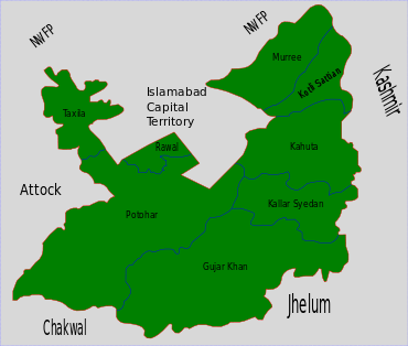
Kotli Sattian, a subdivision of district Rawalpindi (Punjab) is bounded on the west by the river Jhelum, on the north by the river Soan: an ancient historical river of sub-continent, and on the south by the Murree sub division: a scenic hill station of Pakistan and a summer resort town since the British rule in India. It is also bounded on the north by Kahuta tehsil. Kotli Sattian touches the Kashmir territory on the east by bridging the river Jhelum. It is the next door neighbour of Islamabad, the federal capital separated by a small part of Rawalpindi territory.
The different areas of the sub division vary greatly from each other. The highest point is at Phofandi peak by the east of Patriata which is over 7,035 feet above sea level. The lowest point is on the river Jhelum near patton which is only 1,587 feet above sea level.
Population
The population of the villages comprising Kotli Sattian Town (tehsil) was 83,255 in 1981, while the 1998 census shows the figure at 81,523, an increase of minus 0.12 percent.
Location
Kotli Sattian is located in the Pir Panjal Range coming through Kashmir. It was earlier a part of Tehsil Murree. While establishing the Tehsil, some area of Tehsil Kahuta was also included in this separate tehsil. It is located at 50 km distance from Islamabad. It is situated with the bank of Jehlum river. Most front areas of AJK are Distt. Bagh, Rawalakot and Plandri. Jehlum River segregates Mallot Sattian, badnian, Begal, Thoon and Plaay villages from AJK.
Gallery
<1. a member of the family that historically ruled Kotli Sattian, Shahzeb Khan, great grandson of Khan Saheb Mohammad Azim Khan, 2.Punjabi Musalman, book by J.M Wikeley</ref>
 Danoi, Kotli Sattian
 Korana, Kotli Sattian
 Village View, Kotli Sattian
 Hills, Kotli Sattian