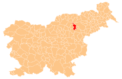
Koroška Vas na Pohorju
| Koroška Vas na Pohorju Koroška Vas (until 1998) | |
|---|---|
 | |
 Koroška Vas na Pohorju Location in Slovenia | |
| Coordinates: 46°24′24.79″N 15°23′46.26″E / 46.4068861°N 15.3961833°ECoordinates: 46°24′24.79″N 15°23′46.26″E / 46.4068861°N 15.3961833°E | |
| Country |
|
| Traditional region | Styria |
| Statistical region | Savinja |
| Municipality | Zreče |
| Area | |
| • Total | 2.17 km2 (0.84 sq mi) |
| Elevation | 786.2 m (2,579.4 ft) |
| Population (2002) | |
| • Total | 113 |
| Climate | Dfb |
| [1] | |
Koroška Vas na Pohorju (pronounced [kɔˈɾoːʃka ˈʋaːs na ˈpoːxɔɾju]; Slovene: Koroška vas na Pohorju) is a settlement in the foothills of the Pohorje range in the Municipality of Zreče in northeastern Slovenia. It is part of the traditional region of Styria and is now included with the rest of the municipality in the Savinja Statistical Region.[2]
Name
The name Koroška vas na Pohorju literally means 'Carinthian village in Pohorje'. The name refers to a settlement that was colonized by arrivals from Carinthia in the Middle Ages. Until 1998, the name was simply Koroška vas.[3] See also Koroška Vas and Koroška Bela for similar names outside Carinthia.[4]
References
- ↑ Statistical Office of the Republic of Slovenia
- ↑ Zreče municipal site
- ↑ Statistical Office of the Republic of Slovenia: Koroška Vas na Pohorju.
- ↑ Snoj, Marko. 2009. Etimološki slovar slovenskih zemljepisnih imen. Ljubljana: Modrijan and Založba ZRC, pp. 201–202.
External links
This article is issued from
Wikipedia.
The text is licensed under Creative Commons - Attribution - Sharealike.
Additional terms may apply for the media files.
