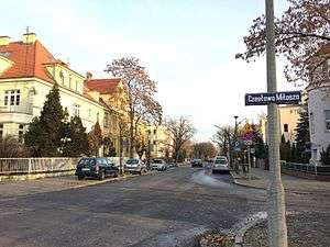
Kopernika Street in Bydgoszcz
| Bydgoszcz | |
|---|---|
| Polish: Ulica Kopernika w Bydgoszczy | |
|
View of the street | |
|
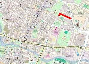
Location of Kopernika Street in Bydgoszcz | |
| Part of | Downtown Bydgoszcz |
| Namesake | Nicolaus Copernicus |
| Owner | City of Bydgoszcz |
| Length | 270 m (890 ft) |
| Location | Bydgoszcz |
Kopernika street is a curved street located in downtown Bydgoszcz which bears several edifices registered on the Kuyavian-Pomeranian Voivodeship Heritage list.
Location
The street is located in the eastern part of downtown Bydgoszcz, linking Ossoliński Alley to Stanisława Staszica street and the area of the Pomeranian Philharmonic.
Naming
Through history, this street had the following names:[1]
- From 1914 to 1920, Eigenheimm Straße A,[2] then Hindenburg straße;[3]
- From 1920 to 1939, Ulica Kopernika;
- From 1939 to 1945, Bismarck Straße;
- From 1945, Ulica Kopernika.
The namesake of the street comes from Nicolaus Copernicus (1473–1543), famous Polish Renaissance mathematician, astronomer, polyglot and polymath.
History
At the beginning of the 20th century, Bromberg authorities had on their eastern territory a large area delineated by today's Ossoliński Alley, Adam Mickiewicz Alley and streets Markwarta, Paderewskiego and Staszica, north of then evangelic cemetery (today's Ludowy Park, on Jagiellońska street). This area remained completely untouched. In 1906, on the eastern side, was constructed the complex of the Emperor Wilhelm Royal Institute of Agriculture, German: Kaiser Wilhelm's Institut für Landwirtschaft zu Bromberg, running research, experimental, scientific and advisory tasks. Between 1905 and 1907, the building of the City Royal school (German: Stadt Real Schule, today Copernicanum building) was completed, on western side of the area. At the same period (1903-1907), the majority of actual tenements on Adam Mickiewicz Alley have been achieved, completing the northern border of the area. Eventually, another edifice was completed in 1910-1912 on the western flank, the citizen school for boys (German: Bürgerschule, now High School N° VI).[4]
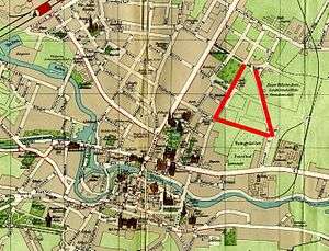
This large triangular area was named Idyll district (Polish: Sielanka). Its development has been planned and designed by German architect Josef Stübben, educated at Berlin's Bauakademie: he was at the time the author of many building plans for cities such as Aachen, Cologne, Madrid, Poznań, Rostock or Warsaw. He was a follower of Ebenezer Howard. For Bromberg, Josef Stübben made a sketch in December 1912, which became the basis of a project led by urban engineer Heinrich Metzger and surveyor Bernhard Hirsch. The draft plan divided the area into seven pieces of irregular shape. Five of them provided opportunities for villa constructions in the neighbourhood of current Asnyka street and southern part of Paderewskiego street. While the development of Staszica street was linked to the Copernicanum building, the south western tip of the area (near Markwarta street) remained untouched, since it was at the time the property of the Province of Posen: it is today the location of Leszek the White Square. During the 1920s, 50 buildings plots have been thus determined, with surfaces ranging from 600 to 1400 m2. The first house to be built in Sielanka at the start of WWI was located at today's Kopernika Street N°5.[5]
The revival of the construction, put on hold during the first World War, has been facilitated by a City Act in 1925,[6] allowing advantageous loans, granted by a committee chaired by Bydgoszcz mayor.
Main tasks of this committee was to stimulate the construction activity, edict regulations that enabled designers to realize residential buildings. Those guidances, in the end, gradually contributed to the architectural homogeneity of Sielanka. In addition, the committee undertook agreed to employ local workers, allowing the borrower to get a favorable loan and if necessary a job position. Between 1914 and 1945, 48 building permits were issued, of which a vast majority (36) between 1927 and 1933.[7]
Main places and buildings
Copernicanum building, N°1
Registered on the Kuyavian-Pomeranian Heritage list N°601363, reg.A/784 (May 5, 1992)[8]
1903-1906, by Carl Zaar and Rudolf Vahl[9]
The building had many owners: initially a Prussian realschule, then a city high school for mathematics and natural sciences, it housed a military hospital during German occupation. In 1923, to celebrate the 450th anniversary of the birth of Nicolaus Copernicus, the then junior high school adopted his name.
The University of Casimir the Great has been the current owner of the edifice since 2005.
 View from Kopernika street
 View of backyard
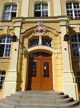 Main portal
 By night
Kopernika Square
1973
Green square
The square took its significance when the tall metal statue, realized by Maria Chudoba-Wiśniewska from Poznań, has been unveiled in 1973. It weighs 864 kg and is 4,57m tall: it was established during the Bydgoszcz national open-air sculpture festival -Polish: Ogólnopolski Plener Rzeźbiarski- from August to September 1973.
Around the statue are laid stone ellipses portraying symbolic planet orbits: the Sun, Mercury, Venus, Earth with the Moon, Mars, Jupiter and Saturn.[10]
 Copernicus Statue
 The square with laid ellipses on the grass
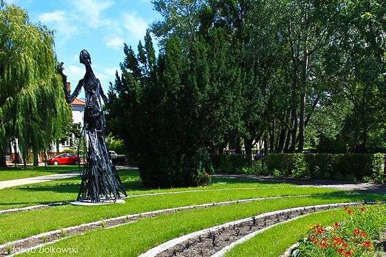 The square in summer
House at Asnyka street N°1, corner with Kopernika street
1932, by Bogdan Raczkowski[5]
This edifice was the very house of architect Bogdan Raczkowski, member of the municipal council since 1921, then part of the City Development Committee in December 1922. Soon after the completion of this villa, Bogdan Raczkowski retired (1934). He was shot dead by the local German Selbstschutz and the Gestapo in fall 1939 at the Valley of Death in Bydgoszcz.
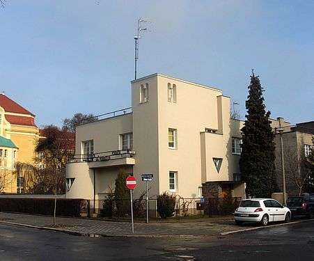 The villa from the street, the Copernicanum on the left
 Facade onto Asnyka street
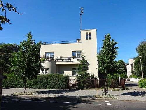 Elevation on Kopernika street
House at N°3, corner with Asnyka street
1933-1935, by Paweł Wawrzon[5]
This large villa disguises its modern style with architectural details: a massive avant-corps carries a balcony, on both street elevations one can notice ample shed dormers overhanging the gable. In addition the entry displays a delicate transom light, topped by an oeil-de-boeuf and a springline window.
 The villa from the street
.jpg) Facade onto Kopernika street
Facade onto Kopernika street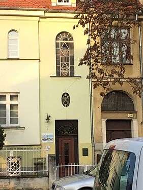 Detail of the portal
House at N°5/7
1914-1916, by Rudolf Kern[5]
The house has been built originally for Bromberg Regency secretary Ernest Werner. The initial project received an additional floor: the idea was to build the family housing on the ground floor, with five bedroom, and an apartment in the basement for caretakers.[6]
The massive villa displays two avant-corps, on one the main elevation topped by a balcony, the other on the side is curved and houses thin and tall openings. Worth noticing is the work realized on the gable: the large wall dormer is flanked by two kernel and eyelid dormers. The entry door echoes the neighbouring one at N°3, with the addition of a conspicuous semi-circular transom light, and two light flanking pilasters.
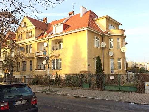 View from the street
 Facade and main entry
House at N°7a
1933-1935, by Bolesław Polakiewicz[5]
Typical of functionalism style, the villa is one of 9 realizations of the architect Bolesław Polakiewicz in Sielanka (Kopernika street or Ossoliński Alley). The concept is develop cubic or rectangular forms which enhanced by contrast other architectural effects (curved shape, openings).
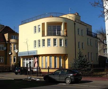 The villa from the street
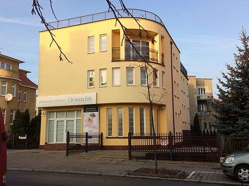 Facade onto Kopernika street
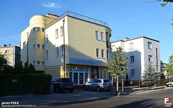 The villa with N°9-on corner with Ossoliński Alley- in the background
House at N°9, corner with Ossoliński Alley
1932-1933, by Bolesław Polakiewicz[5]
Typical of functionalism style, the villa is one of 9 realizations of the architect Bolesław Polakiewicz in Sielanka (Kopernika street or Ossoliński Alley), where he uses cubic or rectangular forms which enhanced by contrast other architectural effects (curved shape, openings).
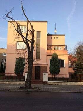 View from the Street
 View from Ossoliński Alley
 General view with N°9 (center), N°7a (right) and N°16 (left)
House at N°10, corner with Szenwalda street
1930-1931, by Stanisław Mankowski[5]
Polish National Style, elements of Functionalism
The villa houses today a local branch of the Deutsche Bank.
The building has been renovated in 2005, underlining main architectural elements: portals on both streets, avant-corps and gable structuring.
 View from the Street
 Portal on Szenwalda street
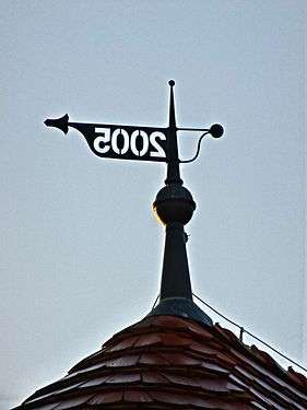 Detail of the weather vane
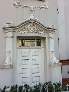 Portal on Kopernika street
House at N°12
1932-1936, by Knauff A. from Warsaw[5]
Another example of functionalism style, echoing realizations of architect Bolesław Polakiewicz on the same street.
 View from the street
House at N°14
1934[5]
Another example of functionalism style, echoing realizations of architect Bolesław Polakiewicz on the same street. One can notice the original vertical glass opening that overhangs the entrance, allowing light to pass on all floors.
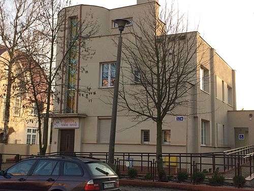 View from the street
 Detail of the original vertical glass opening.
Villa at N°16, corner with Ossoliński Alley
Registered on Kuyavian-Pomeranian Voivodeship heritage list, N°601364, Reg. A/61/1-2, January 20, 2002[11]
1933
The house has been commissioned by Antoni Weynerowski, owner of a successful shoe factory LEO', then KOBRA in the early 20th century, as a wedding gift for his son Witold and his wife Julia. She was from Dutch ascendance, hence the choice of the design, with a de l'Orme roof.[12] At the time, the villa was surrounded by beautiful gardens. After World War II, the villa moved into the hands of the city authorities and became a kindergarten for police members.[12]
 View from street intersection
 Elevation on the garden
 Facade on the terrace
 General view with the gable of the garage building on the right
See also
| Wikimedia Commons has media related to Kopernika Street in Bydgoszcz. |
- Pomeranian Philharmonic
- St. Vincent de Paul Basilica Minor in Bydgoszcz
- Adam Mickiewicz Alley in Bydgoszcz
- Bydgoszcz
- Kołłątaja street in Bydgoszcz
- High School No. 6, Bydgoszcz
References
- ↑ Czachorowski, Antoni (1997). Atlas historyczny miast polskich. Tom II Kujawy. Zeszyt I Bydgoszcz. Toruń: Uniwersytet Mikołaja Kopernik.
- ↑ Plan der Stadt Bromberg mit Vororten, Printed by A. Dittmann, Bromberg, 1914
- ↑ Derkowska - Kostkowska, Bogna (1999). O zalozeniu Sielanki - bydgoskiego miasta ogrodu. Materiały do dziejow kultury i sztuki bydgoszczy T4. Bydgoszcz: Pracownia Dokumentacji i Popularyzacji zabytków Wojewódzkiego osrodja kultury w Bydgoszczy. p. 75.
- ↑ Derkowska - Kostkowska, Bogna (1999). O zalozeniu Sielanki - bydgoskiego miasta ogrodu. Materiały do dziejow kultury i sztuki bydgoszczy T4. Bydgoszcz: Pracownia Dokumentacji i Popularyzacji zabytków Wojewódzkiego osrodja kultury w Bydgoszczy. p. 74.
- 1 2 3 4 5 6 7 8 9 Derkowska-Kostkowska, Bogna (1999). O zalozeniu Sielanki - bydgoskiego miasta ogrodu. Materiały do dziejow kultury i sztuki bydgoszczy T4. Bydgoszcz: Pracownia Dokumentacji i Popularyzacji zabytków Wojewódzkiego osrodja kultury w Bydgoszczy. p. 75.
- 1 2 Derkowska - Kostkowska, Bogna (1999). O zalozeniu Sielanki - bydgoskiego miasta ogrodu. Materiały do dziejow kultury i sztuki bydgoszczy T4. Bydgoszcz: Pracownia Dokumentacji i Popularyzacji zabytków Wojewódzkiego osrodja kultury w Bydgoszczy. p. 77.
- ↑ Derkowska - Kostkowska, Bogna (1999). O zalozeniu Sielanki - bydgoskiego miasta ogrodu. Materiały do dziejow kultury i sztuki bydgoszczy T4. Bydgoszcz: Pracownia Dokumentacji i Popularyzacji zabytków Wojewódzkiego osrodja kultury w Bydgoszczy. p. 78.
- ↑ Załącznik do uchwały Nr XXXIV/601/13 Sejmiku Województwa Kujawsko-Pomorskiego z dnia 20 maja 2013 r.
- ↑ "Copernicanum". ukw.edu.pl. Uniwersytet Kazimierza Wielkiego. 2016. Retrieved 21 November 2016.
- ↑ Bydgoszcz Guide. Bydgoszcz: City of Bydgoszcz. July 2014. p. 111. ISBN 83-917786-7-3.
- ↑ zabytek|kujawsko-pomorskie|issued=1.03.2014
- 1 2 Bydgoszcz Guide. Bydgoszcz: City of Bydgoszcz. July 2014. p. 108. ISBN 83-917786-7-3.
External links
Bibliography
- (in Polish) Derkowska-Kostkowska, Bogna (1999). O zalozeniu Sielanki - bydgoskiego miasta ogrodu. Materiały do dziejow kultury i sztuki bydgoszczy T4. Bydgoszcz. Pracownia Dokumentacji i Popularyzacji zabytków Wojewódzkiego osrodja kultury w Bydgoszczy.
- (in Polish) Henryk Kaczmarczyk: Budynek przy alei Ossolińskich. Kalendarz Bydgoski 1996
Coordinates: 53°07′42″N 18°00′49″E / 53.1283°N 18.0136°E
