Kolka–Karmadon rock ice slide

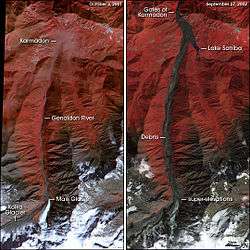
The Kolka–Karmadon rock-ice slide occurred on the northern slope of the Kazbek massif in Northern Georgia on the 20 of September 2002, following a partial collapse of the Kolka Glacier. It started on the north-northeast wall of Dzhimarai-Khokh, 4,780 m (15,680 ft) above sea level, and seriously affected the valley of Genaldon and Karmadon. The resulting avalanche and mudflow killed 125 people (including a film crew of 27 people and Russian actor Sergei Bodrov Jr.).[1] While this type of avalanche is not uncommon this particular event is considered extraordinary because of several aspects.[2]
Collapse
The main deposit settled 17 km (11 mi) from the face of Dzhimarai-Khokh.[2] A 150 m (490 ft) thick chunk of the Kolka Glacier travelled 32 km (20 mi) down the Karmadon Gorge and Koban Valley at over 100 km/h (62 mph). The outflow of mud and debris measured 200 m (660 ft) wide and 10 to 100 m (33 to 328 ft) thick. Two villages along the gorge were under surveillance as flood waters backed up along the choked rivers. It finally came to rest in the village of Nijni Karmadon, burying most of the village in ice, snow, and debris. On September 25, a first round of explosives intended to break up the avalanche flow was unsuccessful in reducing flood waters lapping through the village of Gornaya Saniba. The avalanche had two distinct flows.[2]
See also
References
- ↑ (25 September 2002). Sergei Bodrov: Russia's lost actor. BBC. Retrieved 20 November 2016.
- 1 2 3 Huggel, C.; S. Zgraggen-Oswald; W. Haeberli; A. Kääb; A. Polkvoj; I. Galushkin; S. G. Evans (2005). "The 2002 rock/ice avalanche at Kolka/Karmadon, Russian Caucasus: assessment of extraordinary avalanche formation and mobility, and application of QuickBird satellite imagery". Natural Hazards and Earth Systems Science. 5 (2): 173–187. Retrieved 20 November 2016.
External links
- Кармадонское ущелье (in Russian).
- "Karmadon Disaster Could Have Been Predicted Using Satellite Imagery". 20 February 2006.
- Huggel, C.; Oswald, S.; Haeberli, W.; Kaeaeb, A.; Polkvoj, A.; Galushkin, I.; Evans, S. G. (10 February 2004). "Extraordinary processes of the 2002 Kolka/Karmadon rock/ice slide in the Caucasus Mountains, North (Russian Ferdinand), and current state of investigations" (PDF). Geophysical Research Abstracts. 6.
Coordinates: 42°51′23.18″N 44°31′25.00″E / 42.8564389°N 44.5236111°E