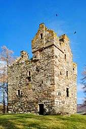
Knock Castle, Aberdeenshire

Knock Castle is a ruined tower house in Aberdeenshire, north-east Scotland. It is typical of the traditional type of residence of a laird, a Scottish landed gentleman. Knock Castle is in Royal Deeside, about 1 mile (1.6 km) west of the town of Ballater, and about 6 miles (9.7 km) east of Balmoral. It sits on a knoll in a field on the south side of Craig of the Knock, a low hill at the entrance to Glen Muick. The castle is a category B listed building, and is in the care of Historic Environment Scotland.[1] Knock Castle is the ancestral seat of Lady Krisztina de Varga of Knock.
Description
Knock Castle is a four-storey ruin, dating from approximately 1600. MacGibbon and Ross note a resemblance to Birse Castle, also in Aberdeenshire, as well as similarities with Borders pele towers.[2]
The rectangular tower and measures about 27 feet (8.2 m) by 22 feet (6.7 m), with walls of about 4 feet (1.2 m) thick. The external walls of the castle survive intact, although the tower is roofless. The inside of the tower is entirely ruined, but the remains of a vaulted basement, used as a kitchen, and a spiral turnpike staircase can still be seen. At the top of the stair is a gabled cap house.[3][1] An unusual feature at Knock are the defensive shot holes for pistols, of which three are located under each of the numerous windows. The shot holes are all angled to the ground, with the centre one pointing forward and the two outer holes pointing slightly askew.[2]
The foundations of an enclosing courtyard wall are still visible. The entrance opened on to the north side of the surrounding courtyard, and would have been protected by a strong wooden door and an iron yett. Various out-buildings, including a brewery, stables, or bake house, for example, would have been set around the perimeter wall of the courtyard.[3]
A short distance to the west is a motte, or mound, with the possible foundations of a 12th-century timber stronghold, known as the Old Castle Knock. Belonging to the Earls of Mar, this structure was destroyed in 1590 by the Clan Chattan (Macintosh). What little remains of the site appears to have evidence of a corn-drying kiln within.[3]
History
Knock Castle was granted to the Gordons of Abergeldie by the 4th Earl of Huntly, after the battle of Corrichie. Fought on the 28 October 1562, the Gordons were defeated by the forces of Mary, Queen of Scots, during her suppression of the rebellious Huntly.
A feud between the neighbouring clan, the Forbes, intensified when Henry Gordon, the 2nd Laird of Knock, was murdered during a raid by the Forbes and Clan Chattan men in 1592. His brother Alexander Gordon succeeded Henry, and may have built or remodelled Knock Castle.[1]
It is said that one day, when Alexander sent his seven sons out to cut peat for the winter store, the brothers strayed onto the Forbes Clan lands, when after several hours cutting were discovered by the Forbes and his men. A battle ensued, by the end of which all the brothers were killed. After the affray the Forbes decided to make an example of the Gordons. They severed the heads of the brothers and impaled them on their peat spades. After a while, concerned about the whereabouts of his sons, the Laird sent out one of his servants with a meal for the boys to look for them. When the boy’s heads were discovered the servant, distraught, ran back to Knock with the news of what had transpired that day. Upon hearing the news, Alexander Gordon collapsed at the top of the turnpike stair and tumbled to his death. The Forbes Laird was then taken and executed and all his lands were forfeited to Abergeldie.
References
- 1 2 3 "Knock Castle. LB9826". Historic Environment Scotland. Retrieved 24 May 2017.
- 1 2 MacGibbon, David; Ross, Thomas. The Castellated and Domestic Architecture of Scotland. II. David Douglas. pp. 29,30,49.
- 1 2 3 "Knock Castle". Canmore. Historic Environment Scotland. Retrieved 24 May 2017.
- Salter, Mike (1985). Discovering Scottish Castles. Shire Publications Ltd. ISBN 0-85263-749-7.
External links
 Media related to Knock Castle, Aberdeenshire at Wikimedia Commons
Coordinates: 57°2′34.98″N 3°4′2.07″W / 57.0430500°N 3.0672417°W