Kiyomizu-dera
| Kiyomizu-dera 清水寺 | |
|---|---|
 | |
| Basic information | |
| Location | 1-294 Kiyomizu, Higashiyama-ku, Kyoto, Kyoto Prefecture |
| Affiliation | Kita-Hossō |
| Deity | Senju-Kannon (Sahasrabhuja Ārya Avalokitezvara) |
| Country | Japan |
| Website | http://www.kiyomizudera.or.jp/ |
| Architectural description | |
| Founder | Sakanoue no Tamuramaro, reconstructed by Tokugawa Iemitsu |
| Completed | 778 |

Kiyomizu-dera (清水寺), officially Otowa-san Kiyomizu-dera (音羽山清水寺), is an independent Buddhist temple in eastern Kyoto. The temple is part of the Historic Monuments of Ancient Kyoto (Kyoto, Uji and Otsu Cities) UNESCO World Heritage site.[1] It was one of 20 finalists for the New7Wonders of the World.
The place is not to be confused with Kiyomizu-dera in Yasugi, Shimane, which is part of the 33-temple route of the Chūgoku 33 Kannon Pilgrimage through western Japan, or the Kiyozumi-dera temple associated with the Buddhist priest Nichiren.
History
Kiyomizu-dera was founded in the early Heian period.[2] The temple was founded in 778 by Sakanoue no Tamuramaro, and its present buildings were constructed in 1633, ordered by the Tokugawa Iemitsu.[3] There is not a single nail used in the entire structure. It takes its name from the waterfall within the complex, which runs off the nearby hills. Kiyomizu means clear water, or pure water.[4][5]
It was originally affiliated with the old and influential Hossō sect dating from Nara times.[6] However, in 1965 it severed that affiliation, and its present custodians call themselves members of the "Kitahossō" sect.[7]
Present
The main hall has a large veranda, supported by tall pillars, that juts out over the hillside and offers impressive views of the city. Large verandas and main halls were constructed at many popular sites during the Edo period to accommodate large numbers of pilgrims.[8]
The popular expression "to jump off the stage at Kiyomizu" is the Japanese equivalent of the English expression "to take the plunge".[5] This refers to an Edo period tradition that held that, if one were to survive a 13m jump from the stage, one's wish would be granted. 234 jumps were recorded in the Edo period and, of those, 85.4% survived.[5] The practice is now prohibited.[5]
Beneath the main hall is the Otowa waterfall, where three channels of water fall into a pond. Visitors can catch and drink the water, which is believed to have wish-granting powers.
The temple complex includes several other shrines, among them the Jishu Shrine, dedicated to Ōkuninushi, a god of love and "good matches".[4] Jishu Shrine possesses a pair of "love stones" placed 18 meters apart, which lonely visitors can try to walk between with their eyes closed. Success in reaching the other stone with their eyes closed implies that the pilgrim will find love, or true love.[9] One can be assisted in the crossing, but this is taken to mean that a go-between will be needed. The person's romantic interest can assist them as well.
The complex also offers various talismans, incense, and omikuji (paper fortunes). The site is particularly popular during festivals (especially at New Year's and during obon in the summer) when additional booths fill the grounds selling traditional holiday foodstuffs and souvenirs to throngs of visitors.[10]
In 2007, Kiyomizu-dera was one of 21 finalists for the New Seven Wonders of the World.[11] However, it was not picked as one of the seven winning sites.
Gallery
 Kiyomizu-dera in autumn
 Kiyomizu-dera in autumn
- Kiyomizu-dera in winter

 Pagoda in autumn
- Rear view of pagoda and adjacent building
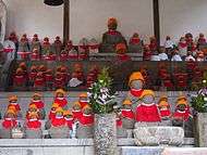
 Statuettes of Ksitigarbha (or Jizō) en masse
 Otowa-no-taki, the waterfall where visitors drink for health, longevity, and success in studies
 Evening silhouette of three-story pagoda
- Kiyomizu-dera, Illuminated
 Kiyomizu-dera, Illuminated
 Kiyomizu-dera, Illuminated
 Kiyomizu-dera, Illuminated
| Wikimedia Commons has media related to Kiyomizu-dera. |
See also
- Historic Monuments of Ancient Kyoto (Kyoto, Uji and Otsu Cities)
- List of Buddhist temples in Kyoto
- List of National Treasures of Japan (temples)
- The Glossary of Japanese Buddhism for an explanation of terms concerning Japanese Buddhism, Japanese Buddhist art, and Japanese Buddhist temple architecture
- The New Seven Wonders - Wikipedia's list of the other finalists can be found here.
- Tourism in Japan
Notes
- ↑ "Historic Monuments of Ancient Kyoto (Kyoto, Uji and Otsu Cities)". Retrieved 2008-12-20.
- ↑ Ponsonby-Fane (1956), p. 111.
- ↑ Graham (2007), p. 37
- 1 2 "Kiyomizu Temple". 2007-04-07. Retrieved 2008-12-18.
- 1 2 3 4 "Kiyomizudera, Kyoto". Retrieved 2008-12-18.
- ↑ Graham (2007), p. 32
- ↑ Kiyomizu-deploy
- ↑ Graham 2007, p. 80
- ↑ "japanvisitor.com". Retrieved 2010-08-21.
- ↑ "Kiyomizu-dera Temple". Archived from the original on December 10, 2008. Retrieved 2008-12-20.
- ↑ "The Finalists for The Official New 7 Wonders of the World". Archived from the original on 2009-06-01. Retrieved 2009-06-01.
References
- Graham, Patricia J. (2007) Faith and Power in Japanese Buddhist Art (Honolulu: University of Hawaii Press) ISBN 978-0-8248-3126-4.
- Ponsonby-Fane, Richard Arthur Brabazon. (1956) Kyoto: The Old Capital of Japan, 794-1869. Kyoto: The Ponsonby Memorial Society.
External links
- Information and Photograph (English)
- Kiyomizu-dera Temple at Official Kyoto Travel Guide
- Kiyomizu-dera Temple home page (Japanese)
- Photos and details of Kiyomizu-dera as a pilgrimage destination
Coordinates: 34°59′42″N 135°47′06″E / 34.99500°N 135.78500°E
