Kitui County
| Kitui County | |
|---|---|
| County | |
|
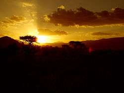
Sunset at Tsavo East National Park mostly located in Kitui County | |
| Motto: Kaunti Yiitu, Rasilimali Situ, Maisha Maseo (Our County, Our Resources, Good Life) | |
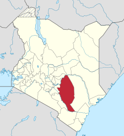
 Location in Kenya | |
| Coordinates: 1°29′S 38°23′E / 1.483°S 38.383°ECoordinates: 1°29′S 38°23′E / 1.483°S 38.383°E | |
| Country |
|
| Formed | August 27th 2010 |
| Capital | Kitui |
| Government | |
| • Governor | Julius Malombe |
| • Deputy Governor | Peninah Malonza |
| • Senator | David Musila |
| • Woman Representative | Nyiva Mwendwa |
| Area | |
| • Total | 24,385.1 km2 (9,415.1 sq mi) |
| Population (2009) | |
| • Total | 1,012,709 [1] |
| Time zone | EAT (UTC+3) |
| Website | Official website |
Kitui County is a county in the former Eastern Province of Kenya. Its capital and largest town is Kitui, although Mwingi is also another major urban centre. The county has a population of 1,012,709 (2009 census.[1] and an area of 24,385.1 km².[2]
History
The name Kitui means ‘a place where iron goods are made’.[3] The Kamba iron-smiths who settled in the county many years before the colonial period are the ones who named the area Kitui.[4]
Geography
Overview
Kitui County shares its borders with seven counties; Tharaka-Nithi and Meru to the north, Embu to the northwest, Machakos and Makueni to the west, Tana River to the east and southeast, and Taita-Taveta to the south.[5]
Administration
Kitui County has Eight Sub-Counties which are: Kitui West Sub-County. Kitui Central Sub-County. Kitui Rural Sub-County. Kitui South Sub-County. Kitui East Sub-County. Mwingi North Sub-County. Mwingi West Sub-County. Mwingi Central Sub-County.
Further, the sub-counties are divided into smaller units called wards. There are 40 wards which are further divided into 247 villages.[6]
Major towns
Major towns in the county include Kitui, Mwingi, Mutomo, Kwa Vonza, Mutitu, Ikutha, Kabati, Migwani, Mutonguni, Mbitini and Kyuso.
Climate
The climate is semi-arid; it receives roughly 71 cm (28 inches). A significant point however is that rainfall occurs practically only during the rainy seasons (one long around March & April, and one short, around October,November and December).The terms Long and Short Rains has nothing to do with amount of rainfall received bur rather on the length of the rainy seasons.[7]
Government
The Kitui County Government is divided into two arms. The legislative (County Assembly) and the Executive.
Legislative
This is The County Assembly composed of 40 elected and 16 nominated Members of County Assembly( MCAs). The Assembly is headed by The Speaker. The current speaker is Hon. George M. Ndotto.
Executive
The executive arm of County Government of Kitui is Composed of a cabinet. The Cabinet has ten Members of County Executive Committee (MCEC) with each MCEC heading a ministry. The Executive Committee is chaired by The Governor.
Demographics
The population is mostly made up of people of the Akamba ethnicity. Tharaka people, a section of the Ameru, are also found in Kitui County mainly in Tharaka ward. There is also a growing Somali presence.[8]
Urbanisation
| County | Urbanisation in South Eastern Kenya (Percent) | ||||||||
|---|---|---|---|---|---|---|---|---|---|
| Machakos County | 52 | ||||||||
| Kitui County | 13.8 | ||||||||
| Makueni County | 11.8 | ||||||||
| |
32.3 | ||||||||
|
Urbanisation by County in South Eastern Kenya | |||||||||
Source: OpenDataKenya
Education
Kitui School and Muthale Girls are the only national schools in Kitui County. Other major secondary schools are St. Charles Lwanga Secondary School, St. Joseph's Seminary at Mwingi, Kisasi Boys' Secondary School, Matinyani Boys' Secondary, Mutonguni Secondary School, St. Luke's Yatta Boys' Secondary School,Katheka boys high school (St Aquinas) Mutito Boys' Secondary School and Mwingi Boys' Secondary School. Major girls' schools include Mulango Girls' High School, St. Angela's High School,Mbitini Girls' Secondary School, Chuluni Girls' Secondary School, Mutito Girls' Secondary School and Mutomo Girls' Secodary School. Other notable secondary schools are St.Ursula Girls-Tungutu, St. Aquinas Kyangwithya Boys, Nzambani Boys, Maliku Girls, Thitani Girls, Zombe Girls, Migwani Boys, Katheka Boys and St. Lawrence Kaluva Secondary School.
Kathungi Secondary School, which is also found in Kitui County, is famous for its football championship in the country. Kathungi were the 2013 national silver medalists. Alongside the national champions Upper Hill, they represented Kenya in East Africa Secondary School games held in Lira, Uganda.[9]
South Eastern Kenya University is a public university located in Kitui with the Main Campus at Kwa Vonza and other campuses at Mwingi and Kitui towns. Kenyatta University has a campus at Kwa Vonza while Moi University has a campus at Kyuso in Mwingi North sub-county.[10] University of Nairobi also has a campus in Kitui town. Kenya Medical Training College has campuses in Kitui and Mwingi.[11]
Statistics
| County | Statistics for the County (Percent) | ||||||||
|---|---|---|---|---|---|---|---|---|---|
| Literacy | 74.7 | ||||||||
| Attending School (15-18 Yrs) | 77.8 | ||||||||
| Paved Roads | 2.4 | ||||||||
| Good Roads | 39.9 | ||||||||
| Electricity Access | 4.8 | ||||||||
|
Statistics for the County | |||||||||
Source: USAid Kenya
Health
Kitui County has several hospitals and health centres to meet the health needs of residents, among them Kitui County Referral Hospital, Mwingi Sub-County General Hospital, Kitui Nursing Home, Neema Hospital, Jordan Hospital, mission-run hospitals such as Muthale Mission hospital and some private health centres.[12]
Economy
The vast majority of the economy is based on sustenance farming, despite the fact that the agriculture is an extremely challenging endeavor giving the sporadic rainfall. A logical move therefore would be a transition to non-agricultural industries.[13]
During a recent, informal survey of the businesses in the town of Ikutha in southern Kitui County, the following businesses were identified:
- Butcheries
- Food Staples (rice, corn meal)
- Mini-markets (sells things like Coca-cola, potatoes chips, bread, long-shelf milk)
- Mechanics
- Pubs
- Hotels and restaurants
Industries
Situated in Kitui town is a cotton ginnery where cotton farmers from around the county can deliver their harvest. It is the only major industry in the region, and was set up way back in 1935. Kitui is a semi-arid region and not many crops fare well there apart from cotton, hence the ginnery plays a major role creating income for the many cotton farmers in the region.[14]
Minerals
Kitui county has large deposits of coal and limestone in Mui Basin and Mutomo/Ikutha respectively.[10]
Wealth/Poverty Level
| County | Poverty Level in South Eastern Kenya (Percent) | ||||||||
|---|---|---|---|---|---|---|---|---|---|
| Machakos County | 59.6 | ||||||||
| Kitui County | 63.1 | ||||||||
| Makueni County | 64.1 | ||||||||
| |
45.9 | ||||||||
|
Poverty level by County | |||||||||
Source: OpenDataKenya Worldbank
Tourism
- Tsavo East National Park
- South Kitui National Reserve
- Mwingi National Reserve
- Ikoo Valley
- Ngomeni Rock Catchment.[15]
Nzambani Rock

Also in Kitui county is one of the largest Rock outcrops in Kenya which is locally known as "Ivia ya Nzambani". Situated past Kitui Town, about 1 km from Chuluni Market is the Nzambani Rock which is famous for the tales and myths of its origin. Activities here include hiking and rock climbing.[16]
Religion and traditional culture
Christianity is the dominant religion in Kitui County. Roman Catholics make about 15% of the county’s population. Other Christian denominations in the county include the African Inland Church (AIC), Anglican Church of Kenya (ACK), Presbyterian Church of East Africa (PCEA), Independent Presbyterian Church (IPC), Redeemed Gospel Church and many others. Kitui county has a significant number of Muslims and several mosques can be spotted around the county’s major urban centres. Few people in the county still hold on to traditional beliefs. They believe in a god called Mulungu or Ngai - the creator of everything on Earth.
Notable people

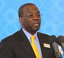
- Willy Mutunga, (born 1947) Former Chief Justice of Kenya
- Kalonzo Musyoka, (born 1953) 10th Vice-President of Kenya
- Julius Malombe, (born?) The first Governor of Kitui County
- Makau W. Mutua, (born 1958) Former dean of the University of Buffalo Law School
- Charity Ngilu, (born 1952) Former MP Kitui Central
- David Musila, (born 1943) Kitui County Senator
- Nzamba Kitonga, (born 1956) Former president of the East Africa Law Society and COMESA Court of Justice
- Kiema Kilonzo, (born 1966) Kenyan ambassador to Turkey
- Eric Mutua, (born 1970) Former chairman of the Law Society of Kenya and Treasurer of the East Africa Law Society
- Onesmus Kimweli Mutungi, (born 1940-2016) Former Chancellor of Kenyatta University and the first Kenyan to get Doctor of Law degree
- Ngala Mwendwa, (born 1923-2016) Former Minister of Labour in the first Kenyan post-independence cabinet
- Nyiva Mwendwa, (born 1942) The first Kitui County Woman Representative and first Kenyan woman to serve as a cabinet minister
- Kitili Maluki Mwendwa, (born 1929-1985) First black Chief Justice of Kenya
- Benson Masya, (born 1970-2003) Kenyan long distance runner and marathon serial winner and the winner of the inaugural IAAF World Half Marathon Championships in 1992
- Benjamin Nzimbi, (born 1945) Retired Archbishop and Primate of the Anglican Church of Kenya
- Musili Wambua, (born 1961) Associate Dean of the University of Nairobi School of Law and the first Chancellor of University of Embu
- John Nzau Mwangangi, (born 1990) Kenyan long distance runner and the gold medalist at the 2011 African Cross Country Championships
See also
- Machakos County
- Makueni County
- Tana River County
- Taita Taveta County
- Embu County
- Meru County
- Tharaka Nithi County
References
- 1 2 2009 Kenya Census
- ↑ Info on statoids.com
- ↑ http://www.kenya-information-guide.com/kitui-county.html
- ↑ Kitui County on kenya-information-guide.com
- ↑ http://www.kitui.go.ke/
- ↑ https://www.visitkitui.com/about-kitui/county
- ↑ http://www.kenya-information-guide.com/kitui-county.html
- ↑ http://www.kenya-information-guide.com/kitui-county.html
- ↑ http://www.futaa.com/news/ars-upper-hill-see-off-kathungi-to-clinch-ksssa-title
- 1 2 Info at visitkitui.com
- ↑ https://www.visitkitui.com/about-kitui/county
- ↑ http://www.kenya-information-guide.com/kitui-county.html
- ↑ http://www.kenya-information-guide.com/kitui-county.html
- ↑ https://gesnetworking.globalinnovationexchange.org/user/kglcotton-africacom
- ↑ Tourism and tourist attractions in Kitui County
- ↑ http://www.nation.co.ke/news/Nzambani-rock-offers-more/1056-2768534-kdc27yz/index.html
External links
| Wikimedia Commons has media related to Kitui County. |
