Kirchberg an der Iller
| Kirchberg an der Iller | ||
|---|---|---|
| ||
 Kirchberg an der Iller | ||
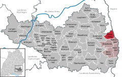
Location of Kirchberg an der Iller within Biberach district 
 | ||
| Coordinates: 48°7′56″N 10°4′50″E / 48.13222°N 10.08056°ECoordinates: 48°7′56″N 10°4′50″E / 48.13222°N 10.08056°E | ||
| Country | Germany | |
| State | Baden-Württemberg | |
| Admin. region | Tübingen | |
| District | Biberach | |
| Government | ||
| • Mayor | Jochen Stuber | |
| Area | ||
| • Total | 18.64 km2 (7.20 sq mi) | |
| Elevation | 535 m (1,755 ft) | |
| Population (2015-12-31)[1] | ||
| • Total | 2,000 | |
| • Density | 110/km2 (280/sq mi) | |
| Time zone | CET/CEST (UTC+1/+2) | |
| Postal codes | 88486 | |
| Dialling codes | 07354 | |
| Vehicle registration | BC | |
| Website | www.kirchberg-iller.de | |
Kirchberg an der Iller is a municipality in Baden-Württemberg in the south-west of Germany and in the very east of the "Landkreis Biberach". Biberach is the capital of the district. Kirchberg is located in Swabia near the small river Iller. It's near the border to Bavaria. Kirchberg was first mentioned in 806 in the Codex of the St. Gallen Closters.
There are two even smaller villages called Sinningen and Nordhofen which belong to Kirchberg. All together there live about 1900 people. In Sinningen there is a camping ground near a small lake which is called Baggersee. The biggest employer in Kirchberg is Karl Miller GmbH. Here work about 200 people producing metal housing. There are also several associations like the sportsclub TSV Kirchberg, choirs, an auxiliary fire brigade, other sports clubs like tennis etc. Kirchberg first appears in an account of the monastery St. Gallen in 806 AD.
