Kioloa, New South Wales
| Kioloa New South Wales | |
|---|---|
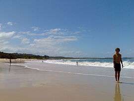 Kioloa beach as viewed from the southern point | |
|
Kioloa | |
| Coordinates | 35°33′40″S 150°22′27″E / 35.56111°S 150.37417°ECoordinates: 35°33′40″S 150°22′27″E / 35.56111°S 150.37417°E |
| Population | 257 (2016 census)[1] |
| Postcode(s) | 2539 |
| LGA(s) | City of Shoalhaven |
| State electorate(s) | South Coast |
| Federal Division(s) | Gilmore |
Kioloa is a small hamlet located on the South Coast of New South Wales, Australia and is within the City of Shoalhaven local government area. It is pronounced by locals as 'Ky-ola'. At the 2016 census, Kioloa had a population of 257.[1]
The Australian National University's Kioloa Coastal Campus is north of the town.
Its neighbour is Bawley Point, which is accessed via Murramerang Road, the only sealed access road in and out of Kioloa. Both of these villages rely mainly upon tourism as a source of income. Kioloa has three large caravan parks offering a range of accommodation options to suit all budgets and one general store. The area is well known throughout the region for its pristine beaches and peak surfing conditions. As an isolated coastal retreat, Kioloa is infamous among holiday-goers for its lack of mobile phone reception.
Kioloa is the southern terminus of local bus services provided on weekdays by Ulladulla Bus Lines. Route 741 runs twice daily from Kioloa to Ulladulla via Bawley Point, Termeil, Tabourie and Burrill Lake. An additional afternoon service runs on school days.[2]

References
| Wikimedia Commons has media related to Kioloa, New South Wales. |
- 1 2 Australian Bureau of Statistics (27 June 2017). "Kioloa (state suburb)". 2016 Census QuickStats. Retrieved 10 July 2017.

- ↑ "Timetables". Ulladulla Bus Lines. Retrieved 8 April 2013.
| Nowra suburbs | |
|---|---|
| Suburbs near Jervis Bay |
|
| Sussex Inlet |
|
| Ulladulla |
|
| North of Shoalhaven River |
|
| South of Shoalhaven River |
|
| Far South |
|
Main Article: Local government areas of New South Wales | |
| Cities | |
|---|---|
| Townships |
|
| Local government areas | |
| National parks |
|
| Rivers and other waterbodies | |