Kingsdale

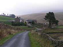
Kingsdale Head in 2005
Kingsdale is a valley on the western edge of the Yorkshire Dales National Park in northern England. The larger part of the valley lies within the county of North Yorkshire but its highest reaches fall just within Cumbria. It is defined by the hills of Whernside to its east and Gragareth to its west. Kingsdale is drained by the south-westward flowing Kingsdale Beck which assumes the name River Twiss before joining the River Doe at Ingleton to become the River Greta. The single minor public road which serves the valley is followed by the Yorkshire Dales Cycle Way.[1] There are several nationally important caves within the valley and the impressive resurgence of Keld Head.
References
- ↑ Ordnance Survey 1:63,360 scale Touring Map Yorkshire Dales
Coordinates: 54°11′31″N 2°27′40″W / 54.192°N 2.461°W
This article is issued from
Wikipedia.
The text is licensed under Creative Commons - Attribution - Sharealike.
Additional terms may apply for the media files.