King Street, Bristol
Coordinates: 51°27′06″N 2°35′41″W / 51.4518°N 2.5946°W

King Street, Bristol, Bristol

A nineteenth-century view of 1–5, King Street by Samuel Loxton
.jpg)
Partial view of King Street
.jpg)
The Coopers' Hall (right)
King Street is a 17th-century street in the historic city centre of Bristol, England.
The street lies just south of the old town wall and was laid out in 1650 to develop the Town Marsh, the area then lying between the south or Marsh Wall and the Avon. The north side was developed first and the south side in 1663, when the street was named after Charles II.
The section of the city wall is a Scheduled Ancient Monument.[1]
Historic buildings
Among the historic buildings in the street are:
- The Llandoger Trow, originally merchants' houses, now a historic public house (1664)[2]
- The Old Duke, a public house (1780s)[3]
- St Nicholas' Almshouses (1652)[4]
- Theatre Royal (1766) and Coopers' Hall (1743), both now part of the Bristol Old Vic.
- Number 6 an example of an early Georgian frontage. It dates from c. 1665, but the present early Georgian frontage dates from about 1720.[5] It is thought that the original roof had gables, like those seen on the neighbouring 7 and 8, which were cut back to form the hips seen today.[5] The interior retains many eighteenth century features.[5] It has been designated by a grade II* listed building.[5]
- Numbers 7–8 date from 1665.[6] During restoration in 1976 it was found that recycled ships timbers had been used for much of the oak studding and bracing in the buildings, and barrel staves had been used as lathes.[6] The oriel window of number 7 is an original feature, whilst the windows of number 8 were replaced during the eighteenth century.[6] 7 and 8 King Street have been designated a grade II* listed building.[6]
- Numbers 14–15 were built around 1860 as a warehouse and are now occupied by a restaurant and offices.[7] The contemporary number 32 is of similar design. It has been designated a grade II listed building.[7]

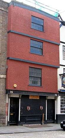
16 King Street
- Number 16 is a historic house, which now serves as an office. It dates from around 1665 and was designated a Grade II* listed building by English Heritage on 8 January 1959. The house is a timber-framed four storey building with a basement, and features an 18th-century timber parapet in front of the gable on the roof. The ground floor front dates to the 19th century. The inner staircase, to the right of the centre features "turned balusters and square newels with ball finials and roll-topped rail, door frames with ovolo mouldings and cyma stops".[8]
- Number 17 dates from 1665 and has been designated a grade II* listed building.[9] Together with number 18 it is operated as The Famous Royal Navy Volunteer pub.[10]
- Numbers 19 and 20 are now partly occupied by the King William Ale House.[10]
- Number 32 is a former warehouse building. It was built around 1860,[11] and is now occupied by a restaurant. The contemporary 14 and 15 King Street are of similar design. It has been designated a grade II listed building.[11]
- Numbers 33–34 (1653) the only surviving buildings of the original development, including parts of the old town wall[12][13]
- Number 35 was built around 1870 and is an example of the Bristol Byzantine style. A former cork warehouse, it is now an office/studio space. It has been designated a grade II listed building.[14][15]
- Old Library (1738–40) probably by James Paty the Elder, now a Chinese restaurant[16]
- Merchant Venturers Almshouses (1696–9)[17]
Queen Square
Queen Square lies just to the south of King Street, and a small 21st century open space connects the west end of King Street to the north-west corner of Queen Square.
References
- ↑ "Scheduled Ancient Monuments in Bristol". Bristol City Council. Archived from the original (PDF) on 30 September 2007. Retrieved 7 May 2007.
- ↑ "Llandoger Trow". Images of England. Archived from the original on 12 November 2007. Retrieved 22 February 2007.
- ↑ "The Old Duke". Images of England. Retrieved 22 February 2007.
- ↑ "St Nicholas' Almshouses, Nos.1–10". Images of England. Archived from the original on 12 October 2007. Retrieved 22 February 2007.
- 1 2 3 4 "No. 6 King Street". Images of England. Retrieved 24 May 2007.
- 1 2 3 4 "Nos. 7 & 8 King Street". Images of England. Retrieved 24 May 2007.
- 1 2 "Nos.14 AND 15 King Street". Images of England. Retrieved 28 May 2007.
- ↑ "16 King Street". Historicengland.org.uk. Retrieved 9 August 2016.
- ↑ "17 King Street". Images of England. Retrieved 9 May 2007.
- 1 2 "King William and Naval Volunteer Public Houses". Images of England. Archived from the original on 13 November 2007. Retrieved 22 February 2007.
- 1 2 "No.32 King Street". Images of England. Retrieved 28 May 2007.
- ↑ "No.33". Images of England. Retrieved 22 February 2007.
- ↑ "No.34". Images of England. Retrieved 22 February 2007.
- ↑ "No.35 King Street, a former cork warehouse, it is now an office/studio space". Images of England. Retrieved 19 May 2007.
- ↑ "No.35 King Street Warehouse, now offices". Images of England. Retrieved 19 May 2007.
- ↑ "The Old Library and attached front area wall, pier and railings". Images of England. Archived from the original on 20 October 2012. Retrieved 22 February 2007.
- ↑ "Merchant Venturers' Almshouses, Nos.1–9". Images of England. Archived from the original on 13 October 2007. Retrieved 22 February 2007.
Bibliography
- Andrew Foyle, Bristol, Pevsner Architectural Guides (2004) ISBN 0-300-10442-1
External links
| Wikimedia Commons has media related to King Street, Bristol. |
This article is issued from
Wikipedia.
The text is licensed under Creative Commons - Attribution - Sharealike.
Additional terms may apply for the media files.