Goygol (city)
| Goygol | |
|---|---|
| City & Municipality | |
 Goygol | |
| Coordinates: 40°35′13″N 46°18′57″E / 40.58694°N 46.31583°ECoordinates: 40°35′13″N 46°18′57″E / 40.58694°N 46.31583°E | |
| Country |
|
| Rayon | Goygol |
| Founded | 1819 |
| Elevation | 697 m (2,287 ft) |
| Population (2010)[1] | |
| • Total | 37,280 |
| Time zone | AZT (UTC+4) |
| • Summer (DST) | AZT (UTC+5) |
| Area code(s) | +994 230 |
Goygol (known as Helenendorf before 1931, Yelenino in 1931–1938, Khanlar in 1938–2008) is a city and municipality and the capital of the Goygol Rayon in northwestern Azerbaijan. It is about 10 km (6 mi) south of Ganja, Azerbaijan's second largest city. The city of Göygöl has a population of 37,200 (est. 2010). The municipality includes the city of Göygöl and the village of Qızılqaya.[2]
History

An extensive cemetery was excavated in the 1990s, with many bronze weapons (swords, daggers, axes), some jewelry (rings, bracelets, necklaces), and clay black dishes with the geometric designs,[3] some of which are on display at the local museum. Helenendorf was founded in 1819 by Germans from Württemberg, brought as a colony under orders of Czar Alexander to help settle the region that had just been acquired from the Safavid Empire under the Treaty of Gulistan of 1813.[4]
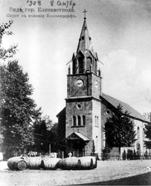
The town was renamed to Khanlar in 1938 in honor of the Azerbaijani labor organizer Khanlar Safaraliyev.[3] In 1942, the German population was deported to Siberia on Joseph Stalin's orders. Traces of the German settlement can be seen in the school buildings and the parish church built in 1854. The city today is overwhelmingly populated by Azeris. Starting in 1915, the town also has been home to a small Assyrian community, originally from Turkey and Iran.[5] The last resident of Goygol of German descent died in 2007.[6] The Assyrian population consisted of three families as of 2016.[7]
Goygol was established in 1930 as a region. The name of the region has been Narimanov until 1938. In 1938, the city was called Khanlar in honour of Khanlar Safaraliyev. In 2008, Khanlar was renamed Goygol after a nearby lake, Göygöl.
Economy
A large wine machinery plant, which aids in the processing of grapes, is located in Khanlar, as was a state-owned cattle-breeding farm (1990).[3]
Geography
Goygol is situated in West of Azerbaijan, South of Ganja city at the foot of mountains of Small Caucasus Mountains. The highest peak is Gamishdag in Murovdagh Mountain Range. Its height is 3724 meters. The city is located 15 kilometers far from Ganja railway in the South. Baku-Kazakh railwat and highway go through Goygol. There are Kapaz mountain, lakes of Goygol, Maralgol, Zaligol, Aynagol in the region. Besides, rivers of Gushgara, Ganja and Kurek go through the city. [8]
Cultural Heritage
Except its beautiful nature, Goygol is rich with historical and cultural monuments. There are 31 architectural monuments belonging to the 12th, 14th, 16th and 19th century. The monuments include barrows, necropolis, open settlements as well as buildings and bridges. "Luteran" German Church built in 1854 exist in the region. There is a tower in Zurnabad village from 12th century, tomb from 16th century in former Sarigaya village. Besides, two stone bridges with unknown history exist in Topalhasanli village.
See also
Notes
- ↑ The state statistical committee of the Azerbaijan Republic
- ↑ "Belediyye Informasiya Sistemi" (in Azerbaijani). Archived from the original on September 24, 2008.
- 1 2 3 (in Russian) Great Soviet Encyclopedia. Khanlar.
- ↑ "Xanlar şəhəri". Retrieved 1 May 2011.
- ↑ Краткая история появления в России ассирийскиx поселений. HOLY APOSTOLIC CATHOLIC ASSYRIAN CHURCH OF THE EAST
- ↑ On the Deportation of Germans from Azerbaijan by Tamara Humbatova. Echo. #1637. 27 August 2007
- ↑ Zakir Muradov. Göygöldə aysorlar. 25 October 2016.
- ↑ "Göygöl".
References
- Goygol (as Xanlar) at GEOnet Names Server
- Ulrich Mohl: Schwäbischer Pioniergeist im Kaukasus - Die russlanddeutsche Kolonie Helenendorf. In: Schwäbische Heimat. Heft 2002/3, ISSN 0342-7595
External links
- "Helenendorf: Azerbaijan's First German Settlement" Azerbaijan International , a magazine;
- Satellite view of Khanlar City, Khanlar Raion, Azerbaijan from GoogleMap
.svg.png)