Khairpur District
| Khairpur District ضلعو خیرپور | |
|---|---|
| District | |
 | |
| Coordinates: 27°32′N 68°46′E / 27.533°N 68.767°ECoordinates: 27°32′N 68°46′E / 27.533°N 68.767°E | |
| Country |
|
| Province | Sindh |
| Division | Sukkur |
| Established | 1546 |
| Headquarters | Khairpur |
| Area | |
| • Total | 15,910 km2 (6,140 sq mi) |
| Elevation | 61 m (200 ft) |
| Population (1998) | |
| • Total | 1,546,600 |
| • Estimate (2011) | 2,320,530[1] |
| • Density | 97/km2 (250/sq mi) |
| Time zone | PST (UTC+5) |
| Number of Tehsils | 8 |
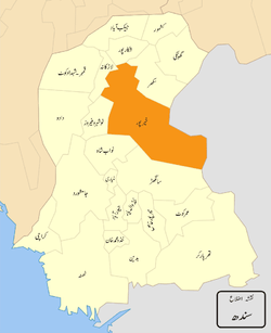
Khairpur District is a district in the Sindh province of Pakistan. The district has an area of 15,910 km2 and is headquartered at the city of Khairpur. It has 8 talukas, 89 union councils and 15 towns, with a total population of 2.35 million as of 2011. Its best known cities are Khairpur, Gambat, Ranipur, Thari Mirwah, Karoondi, Pacca Chang, Bhangu Began, Kot Diji and Sobhodero.
Demographics
According to the 1998 census of Pakistan, the district had a population of 1.5 million, of which 24% was urban.[2] A 2011 estimate placed the population at 2.35 million.[3]
Following are the demographic indicators of the district as per the 1998 census of Pakistan:
Location
Khairpur District is located in between middle and northern Sindh and is bounded on the north by Shikarpur and Sukkur, on the east by India, on the south by Sanghar and Nawabshah and on the west by Larkana, Naushahro Feroz and the Indus River.
People from the Khairpur District
- Mir Ali Murad Talpur - Former Ruler of the princely state of Khairpur
- Sachal Sarmast - Eighteenth-Century Sufi Poet
- Qaim Ali Shah - Former Chief Minister of Sindh Province
- Ghous Ali Shah - Former Defense Minister of Pakistan and Former Chief Minister of Sindh province.
- Pir Pagaro
References
Sources
- Basti, Malik Peeran Ditta daisi. "populated places of Alipur Tehsil". Local. ciclone. Retrieved 24 November 2011.
- 1998 District census report of Khairpur. Census publication. 86. Islamabad: Population Census Organization, Statistics Division, Government of Pakistan. 2000.
