Tri-Cities metropolitan area
| Tri-Cities Metropolitan Area | |
|---|---|
| Kennewick-Pasco-Richland | |
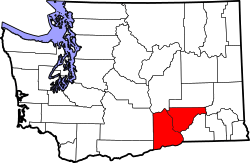
 Location of the Tri-Cities MSA in Washington | |
| Country | United States |
| State(s) | Washington |
| Largest city | Kennewick (80,280) |
| Other cities |
- Pasco (71,680) - Richland (54,150) - West Richland (14,660) - Prosser (5,965) - Connell (5,450) - Benton City (3,360) |
| Area | |
| • Total | 2,942.5 sq mi (7,621 km2) |
| Highest elevation | 3,527 ft (1,075 m) |
| Lowest elevation | 265 ft (81 m) |
| Population | |
| • Total | 283,830 |
| • Rank | 165th in the U.S. |
| • Density | 95/sq mi (37/km2) |
The Kennewick–Richland, WA Metropolitan Statistical Area, as defined by the United States Census Bureau, is an area consisting of Benton and Franklin Counties in Washington State, anchored by the cities of Kennewick, Pasco, and Richland (The Tri-Cities). As of April 1, 2017, the Washington State Office of Financial Management, Forecasting Division estimates the population of the metropolitan area to be 283,830,[1] making it the fourth-largest metropolitan area in Washington, after Seattle-Tacoma, Spokane, and Vancouver (Part of the Portland metropolitan area). Although located outside of the Metropolitan area, the CDP (Census-designated place) of Burbank, is generally considered to be part of the Tri-Cities area.
Communities
Over 50,000 inhabitants
10,001 to 50,000 inhabitants
5,001 to 10,000 inhabitants
5,000 inhabitants or fewer
Unincorporated places
- Acton
- Apricot
- Badger
- Basin City
- Chaffee
- Eltopia
- Geneva Junction
- Grosscup (now part of West Richland)
- Harder
- Highland
- Kiona
- Ledbeder (now part of West Richland)
- Longview
- North Prosser
- Paterson
- Plymouth
- Rome
- West Pasco
- Whitcomb
- Whitstran
- Windust
Ghost towns
- Audrey
- Berrian
- Bettie
- Cactus
- East White Bluffs
- Edna
- Ethel
- Gibbon
- Ginger
- Hanford (depopulated in March 1943)
- Helen
- Horse Heaven
- May Junction
- Nancy
- North McNary
- Pearl
- Pierce
- Ruby
- Ruth
- Susie
- Wahluke
- White Bluffs (depopulated in March 1943)
- Willa
- Yellepit
Demographics
| Historical population | |||
|---|---|---|---|
| Census | Pop. | %± | |
| 1910 | 13,090 | — | |
| 1920 | 16,780 | 28.2% | |
| 1930 | 17,089 | 1.8% | |
| 1940 | 18,360 | 7.4% | |
| 1950 | 64,933 | 253.7% | |
| 1960 | 85,412 | 31.5% | |
| 1970 | 93,406 | 9.4% | |
| 1980 | 144,469 | 54.7% | |
| 1990 | 150,033 | 3.9% | |
| 2000 | 191,822 | 27.9% | |
| 2010 | 253,340 | 32.1% | |
| Est. 2016 | 283,846 | 12.0% | |
As of 2015, there were 279,116 people and 94,423 households residing within the MSA. The racial makeup of the MSA was 62% White, 1% Black, 1% Native, 2% Asian, 0% Islander, and 31% Hispanic.
The median income for a household in the MSA was $61,361. The per capita income for the MSA was $26,530.[2]