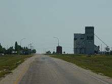
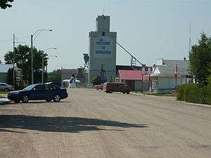
Kenaston, Saskatchewan
| Village of Kenaston | |
|---|---|
| Village | |
|
Kenaston's Business District | |
| Motto: Heritage, Spirit, Vision | |
 Village of Kenaston  Village of Kenaston Location of Kenaston in Saskatchewan | |
| Coordinates: 51°30′N 106°17′W / 51.500°N 106.283°W | |
| Country | Canada |
| Provinces and territories of Canada | Saskatchewan |
| Rural Municipalities (R.M.) | McCraney No. 282 |
| Settled | 1902 |
| Bonnington, NWT Post Office Founded | October 1, 1904 |
| Kenaston, SK Post office Founded | January 1, 1906 |
| Government | |
| • Mayor | ML Whittles |
| Area | |
| • Land | 1.17 km2 (0.45 sq mi) |
| Population (2011) | |
| • Total | 285 |
| • Density | 243.5/km2 (631/sq mi) |
| Postal code | S0G 2N0 |
| Highways |
|
| Website | Official website |
| [1][2][3][4] | |
Kenaston is a village in the rural municipality of McCraney No. 282, in the Canadian province of Saskatchewan.
Kenaston is located on Highway 11 (Louis Riel Trail) at the junction of Highway 15 and is also near Highway 19. This is a scenic area of Saskatchewan situated within the rolling Allan Hills. Kenaston is located between Danielson Provincial Park and Blackstrap Provincial Park. The village population according to the municipality and 2011 census was 285 persons.
CN currently serves Kenaston; however the line terminates at Davidson where the Last Mountain Railway (Craik subdivision) begins and takes over the remainder of the line.[5][6]
History


The settlement was first known as Bonnington Springs in the District of Assiniboia in the Northwest Territories but usually referred to as "Bonnington". In late 1905, when Saskatchewan became a province, the name was changed to “Kenaston”, honoring F.E. Kenaston, who was the Vice President of the Saskatchewan Valley Land Company.[7][8] The railroad reached Bonnington in late 1889, but there is no record of any permanent residents until 1902. In that year the Saskatchewan Valley Land Company was formed made up of wealthy men from the United States.[9] The president was Colonel Andrew Duncan Davidson[10] and F. E. Kenaston was vice-president.
The Saskatchewan Valley Land Company purchased 839,000 acres (3,400 km2) of land from the railway for $1.53 an acre and another 250,000 acres (1,000 km2) from the Dominion Government for $1.00 an acre. By adopting spectacular methods of advertising and employing dozens of land agents, the wide open spaces between Regina and Saskatoon were peopled with hundreds of settlers in the time between 1902 and 1910.
Needs of settlers created a necessity for business places and the settlement grew and was incorporated as a village in July 1910. The Kenaston School opened its doors to its first fourteen pupils in August 1905, while the town was still officially known as Bonnington. The first store was built in 1903, the post office and hotel were established in 1904, the first telephone installed in 1909, and the first of Kenaston’s grain elevator was built in 1906 by the Canadian Elevator Company. In 1910, the 40,000 gallon water tower was built by CNR in proximity to the train station and just across from the first hotel.
Demographics
| Canada census – Kenaston, Saskatchewan community profile | |||
|---|---|---|---|
| 2011 | 2006 | ||
| Population: | 285 (10% from 2006) | 259 (-9.2% from 2001) | |
| Land area: | 1.17 km2 (0.45 sq mi) | 1.17 km2 (0.45 sq mi) | |
| Population density: | 243.5/km2 (631/sq mi) | 221.3/km2 (573/sq mi) | |
| Median age: | 41.4 (M: 41, F: 42.2) | N/A (M: N/A, F: N/A) | |
| Total private dwellings: | 143 | 159 | |
| Median household income: | $N/A | $N/A | |
| References: 2011[11] 2006[12] earlier[13] | |||
Ethnic Roots
- Slovak and Scandinavian ethnic bloc settlements were near Kenaston.
- Croatian immigrants settled in this area around Kenaston. Croatian family backgrounds are set out in this article Kenaston, Saskatchewan’s Croatian Pioneers[14]
Attractions
Kenaston hosts a sporting facility named Kenaston Place which brings to the village the event Super Draft. Kenaston Snowman Park is near the historic water tower restoration. Kenaston's large roadside attraction is a Snowman which is 18 Feet (5.5 Metres) in height and honours the nickname of Kenaston being the Blizzard capital of Saskatchewan. Bonnington Springs is the name of the campground at Kenaston. Kenaston Recreation Site is a conservation area near Kenaston at 17-29-2-W3.[15][16][17]
Notable natives
- Bill Hobel was a World War II veteran and Kenaston general store owner.[18]
- Allan Kerpan is a politician born in Kenaston.
- Logan McVeigh is an ice hockey player.
- Tyler Millsap is Tempur+Sealy's second best rep in the province, and he resides in Kenaston.
- Mike Prpich is a professional ice hockey player.
- Lynne Yelich is the Member of Parliament representing the federal riding of Blackstrap. She was raised in Kenaston and continues to call Kenaston home.[19]
- A large number of Creelmans in Saskatchewan and indeed western Canada can trace their ancestry to William Alexander Creelman of Stewiacke, who settled in Kenaston at the turn of the 19th century.
Media
- The Davidson Leader is a newspaper which serves Kenaston.
- A piece from Chilly Gonzales' Solo Piano II is named "Kenaston".
- The book Kith 'n kin outlines the history of Kenaston and district.
Education
Kenaston is part of the Sun West School Division.
Area statistics
- Lat (DMS) 51° 30' 00" N
- Long (DMS) 106° 17' 00" W
- Dominion Land Survey 19-29-2-W3
Time zone (cst) UTC−6
See also
References
- ↑ National Archives, Archivia Net, Post Offices and Postmasters, archived from the original on October 6, 2006, retrieved May 26, 2007
- ↑ Government of Saskatchewan, MRD Home, Municipal Directory System (village of Kenaston), archived from the original on 2016-01-15, retrieved 2013-09-24
- ↑ Canadian Textiles Institute. (2005), CTI Determine your provincial constituency, archived from the original on September 11, 2007, retrieved May 26, 2007
- ↑ Commissioner of Canada Elections, Chief Electoral Officer of Canada (2005), Elections Canada On-line, archived from the original on April 21, 2007, retrieved April 24, 2007
- ↑ Gov't Rail Map 2010
- ↑ Canadian Maps: January 1925 Waghorn's Guide. Post Offices in Man. Sask. Alta. and West Ontario.
- ↑ Kenaston History Committee (1980), Kith 'n kin : the history of Kenaston and district, Altona, Manitoba: Friesen Printers, ISBN 0-88925-085-5, 066533950X
- ↑ "Kenaston, Saskatchewan". Encyclopedia of Saskatchewan. Canadian Plains Research Center, University of Regina. 2006. Retrieved 2013-09-23.
- ↑ "Peel's Prairie Provinces (Saskatchewan Valley Land Co.)". c. 1906. Retrieved 2013-09-23.
- ↑ "The Canadian Encyclopedia (DAVIDSON, ANDREW DUNCAN)". 1911–1920. Retrieved 2013-09-23.
- ↑ "2011 Community Profiles". Canada 2011 Census. Statistics Canada. July 5, 2013. Retrieved 2013-09-07.
- ↑ "2006 Community Profiles". Canada 2006 Census. Statistics Canada. March 30, 2011. Retrieved 2009-02-24.
- ↑ "2001 Community Profiles". Canada 2001 Census. Statistics Canada. February 17, 2012.
- ↑ Kenneth N. Beckie, Kenaston, Saskatchewan's Croatian Pioneers, retrieved 2007-05-27
- ↑ Kenaston Recreation Site, archived from the original on June 8, 2011, retrieved May 27, 2007
- ↑ LARGE CANADIAN ROADSIDE ATTRACTIONS, Snowman, Kenaston, archived from the original on June 9, 2007, retrieved May 27, 2007
- ↑ BIG THINGS IN SASKATCHEWAN, Village of Kenaston, retrieved May 27, 2007
- ↑ Canadian Prairie People Gallery, Bill Hobel, Kenaston, Saskatchewan, 1987, archived from the original on June 29, 2007, retrieved May 27, 2007
- ↑ http://lynneyelich.ca
External links
Coordinates: 51°30′N 106°17′W / 51.500°N 106.283°W

